HistoricBridges.org Menu: HistoricBridges.org Menu:


We Recommend:
Bach Steel - Experts at historic truss bridge restoration.

HistoricBridges.org: Bridge Browser

120th Avenue Bridge

120th Avenue Bridge

Primary Photographer(s): Nathan Holth

Bridge Documented: Fall/Winter 2006

View Photos
and Videos
View Maps
and Links

Facility Carried / Feature Intersected
120th Avenue Over Little Muskegon River
Location
Rural: Mecosta County, Michigan: United States
Construction Date and Builder / Engineer
1897 By Builder/Contractor: Unknown
Rehabilitation Date
Not Available or Not Applicable
Main Span Length
61.0 Feet (18.6 Meters)
Structure Length
62.0 Feet (18.9 Meters)
Roadway Width
16 Feet (4.88 Meters)
Spans
1 Main Span(s)
Inventory Number
54310H00023B010

Historic Significance Rating (HSR)
View Information About HSR Ratings

Bridge Documentation

Bridge Status: This bridge's owner has applied for 2013 Local Bridge Program demolition funding!

View Archived National Bridge Inventory Report - Has Additional Details and Evaluation

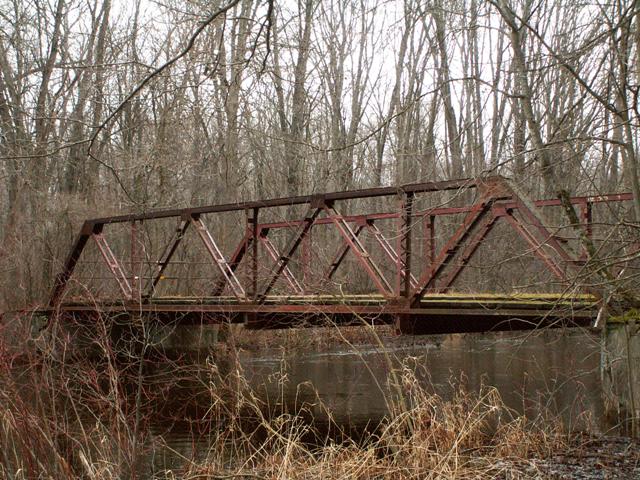
This bridge is a lightweight riveted pony truss with a wooden deck and concrete abutments. Fading red paint still remains on the bridge. The bridge no longer has any railings. The original railings may have been pipe railings, based on remaining mounting rings on some members. There is v-lacing on the verticals. The truss superstructure was listed as "poor" in the 2004 National Bridge Inventory, which is actually rather good for a closed structure. The visual appearance of the bridge during a 2006 visit seemed to confirm this assessment. This is a bridge that could be relocated and restored for a reasonable cost. If the 1897 date given by the historic bridge inventory is correct, then this bridge is historically significant as a very early example of riveted connections on a highway truss in Michigan.


This bridge is tagged with the following special condition(s): Available and Unorganized Photos

Divider

Photo Galleries and Videos: 120th Avenue Bridge


View Photo Gallery

Bridge Photo-Documentation

A collection of overview and detail photos. This photo gallery contains a combination of Original Size photos and Mobile Optimized photos in a touch-friendly popup viewer.
Alternatively, Browse Without Using Viewer

Divider

View Photo Gallery

Additional Unorganized Photos

Original / Full Size Photos
This photo gallery features older ca. 2003-2006 photos taken when the website only included a few photos in original size on the website, and a smaller quantity of reduced size photos as well. This unorganized gallery may partially duplicate photos in other galleries on this bridge's page, however all photos here are available in the Original / Full Size. This gallery offers photos in the highest available resolution and file size in a touch-friendly popup viewer.
Alternatively, Browse Without Using Viewer

Divider

View Photo Gallery

Additional Unorganized Photos

Mobile Optimized Photos
This photo gallery features older ca. 2003-2006 photos taken when the website only included a few photos in original size on the website, and a smaller quantity of reduced size photos as well. This unorganized gallery may partially duplicate photos in other galleries on this bridge's page, however all photos here are available in the Original / Full Size. This gallery features data-friendly, fast-loading photos in a touch-friendly popup viewer.
Alternatively, Browse Without Using Viewer

Divider

Maps and Links: 120th Avenue Bridge

Coordinates (Latitude, Longitude):

Search For Additional Bridge Listings:

Bridgehunter.com: View listed bridges within 0.5 miles (0.8 kilometers) of this bridge.

Bridgehunter.com: View listed bridges within 10 miles (16 kilometers) of this bridge.

HistoricBridges.org Bridge Browser: View listed bridges within 0.5 miles (0.8 kilometers) of this bridge.

HistoricBridges.org Bridge Browser: View listed bridges within 10 miles (16 kilometers) of this bridge.

2021 National Bridge Inventory: View listed bridges within 0.5 miles (0.8 kilometers) of this bridge.

Additional Maps:

Google Maps

Google Streetview (If Available)

Bing Maps

OpenStreetMap

GeoHack (Additional Links and Coordinates)

Apple Maps (Via DuckDuckGo Search)

Apple Maps (Apple devices only)

MapQuest

HERE We Go Maps

ACME Mapper

Waze Map

Android: Open Location In Your Map or GPS App

Flickr Gallery (Find Nearby Photos)

Wikimedia Commons (Find Nearby Photos)

Directions Via Sygic For Android

Directions Via Sygic For iOS and Android Dolphin Browser

USGS National Map (United States Only)

Historical USGS Topo Maps (United States Only)

Historic Aerials (United States Only)

CalTopo Maps (United States Only)


Divider
 
Home Top

Divider

About - Contact

© Copyright 2003-2024, HistoricBridges.org. All Rights Reserved. Disclaimer: HistoricBridges.org is a volunteer group of private citizens. HistoricBridges.org is NOT a government agency, does not represent or work with any governmental agencies, nor is it in any way associated with any government agency or any non-profit organization. While we strive for accuracy in our factual content, HistoricBridges.org offers no guarantee of accuracy. Information is provided "as is" without warranty of any kind, either expressed or implied. Information could include technical inaccuracies or errors of omission. Opinions and commentary are the opinions of the respective HistoricBridges.org member who made them and do not necessarily represent the views of anyone else, including any outside photographers whose images may appear on the page in which the commentary appears. HistoricBridges.org does not bear any responsibility for any consequences resulting from the use of this or any other HistoricBridges.org information. Owners and users of bridges have the responsibility of correctly following all applicable laws, rules, and regulations, regardless of any HistoricBridges.org information.

Admin Login

Divider