

View Information About HSR Ratings
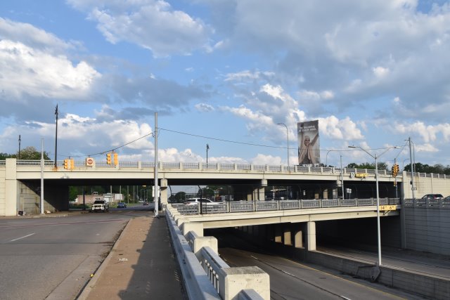
This intersection between two major divided highways and its associated bridges was a major engineering achievement at the time and as such were officially found to be historic by MDOT and rehabilitated. The intersection even has a kiosk with one of Michigan's iconic green historic site interpretive plaques... one of a very small number of historic bridges in Michigan to be given one of these plaques.
During rehabilitation, Michigan's signature R4 railings were retained on both the bridges and the approaches. This interchange is thus one of the largest (if not the largest) intact installations of R4 railing in the state. When Michigan's highways and expressways were being built in the 1940s and 1950s, R4 railing would have been all over the place in the Detroit area. Nearly all R4 railing has been removed from all expressways in Detroit, this divided highway installation of R4 remains notable as a hint of what the older expressways in Detroit once looked like, showing its use not only on the bridges themselves, but on approaches and retaining walls as well.
The dimensions shown for this bridge refer to the largest structure, the top level bridge. The length refers to the bridge proper from abutment face to abutment face. Estimated total length of this structure from end of each approach ramp is 1,445 feet. Approximate length of intersection from the end of ramps on 8 Mile is 2,064 feet. Approximate length of intersection from the end of ramps on Woodward is 2,350 feet.
![]()
![]()
![]()
Coordinates (Latitude, Longitude):
Search For Additional Bridge Listings:
Bridgehunter.com: View listed bridges within 0.5 miles (0.8 kilometers) of this bridge.
Bridgehunter.com: View listed bridges within 10 miles (16 kilometers) of this bridge.
Additional Maps:
Google Streetview (If Available)
GeoHack (Additional Links and Coordinates)
Apple Maps (Via DuckDuckGo Search)
Apple Maps (Apple devices only)
Android: Open Location In Your Map or GPS App
Flickr Gallery (Find Nearby Photos)
Wikimedia Commons (Find Nearby Photos)
Directions Via Sygic For Android
Directions Via Sygic For iOS and Android Dolphin Browser
USGS National Map (United States Only)
Historical USGS Topo Maps (United States Only)
Historic Aerials (United States Only)
CalTopo Maps (United States Only)

© Copyright 2003-2024, HistoricBridges.org. All Rights Reserved. Disclaimer: HistoricBridges.org is a volunteer group of private citizens. HistoricBridges.org is NOT a government agency, does not represent or work with any governmental agencies, nor is it in any way associated with any government agency or any non-profit organization. While we strive for accuracy in our factual content, HistoricBridges.org offers no guarantee of accuracy. Information is provided "as is" without warranty of any kind, either expressed or implied. Information could include technical inaccuracies or errors of omission. Opinions and commentary are the opinions of the respective HistoricBridges.org member who made them and do not necessarily represent the views of anyone else, including any outside photographers whose images may appear on the page in which the commentary appears. HistoricBridges.org does not bear any responsibility for any consequences resulting from the use of this or any other HistoricBridges.org information. Owners and users of bridges have the responsibility of correctly following all applicable laws, rules, and regulations, regardless of any HistoricBridges.org information.
![]()