

View Information About HSR Ratings
This bridge is a typical example of a steel stringer bridge design built in Michigan in the late 1920s and early 1930s. This particular example has an unusual abutment wingwall railing, just one panel, that is a metal design that is unusual, but may appear on a couple other bridges somewhere in Michigan as the primary railing. It is unclear why the wingwall abutment has a different railing design.
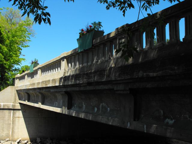
This bridge was rehabilitated as part of a preservation project. The original concrete railings had spalled severely, and they were replicated to the same design as the originals.
Diaphragms between the stringers under the vehicle lanes of the bridge are not original and are metal, but the ones under the sidewalk portions of the bridge are the original concrete diaphragms.
Information and Findings From Michigan Historic Sites OnlineNarrative Description This bridge carries M-88 (North Bridge Street) on the north edge of downtown Bellaire, county seat of Antrim County. A city park (Richardi Park) is to the northeast. An ornamental metal railing tops the bridge's northeast wing wall to protect park users from the steep drop to the riverbed below. The structure's concrete balustrade railings have square balusters and posts. The posts have recessed panels. The balusters are trimmed with two incised vertical lines. A bridge plate on the southeast end post indicates that this trunk line bridge was built by the state highway department in 1931. Holes drilled in the endposts suggest that a guard rail was removed. Sidewalks edge both sides of the roadway. The structure is slightly skewed. Statement of Significance Bellaire's initial development was spurred by lumbering, which was in decline by the late nineteenth century. By that time, however, the community's economy was being stimulated by tourism, as vacationers flocked from Chicago and Detroit to the scenic area around Grand Traverse Bay. By 1931, the steel-truss bridge that had carried the community's main north-south street since 1893, the second bridge in that location, was in need of replacement. The state highway department drafted plans for a new bridge, and in late October awarded a $21,419 contract for the concrete construction to L. W. Lamb, a Jackson contractor, who had completed a bridge in the previous year in nearby Traverse City. The Fort Pitt Bridge Works of Massillon, Ohio, won the bid to provide structural steel for $2,639. The bridge ultimately cost approximately $37,500, including approach work. A ten-man advance crew began site work in Bellaire in early November, with construction planned through the winter and spring. This was welcome news for the town, which was already suffering from high unemployment in the early years of the Depression. The County Relief Committee helped provide workers for the project. By mid-December, the coffer dam was in place and foundation piles were being driven. These footings were 18 inches deeper than normal because, as the state highway department's 1932-1933 biennial report explained, the bridge "was a very unusual and difficult job due to being immediately below a power dam and encroaching on the tail water and flume walls of the power plant. it required special treatment both to fit the site, to protect foundations from scour and to preserve the property of the Power Company." The contractor finished the substructure by the beginning of March 1932, and by the end of that month, the steel girders were in place. The bridge was formally opened to traffic in June. Opening festivities, which were organized by the local fire department and attended by over 1,000 people, included speeches and a square dance on the bridge. The M-88 Bridge qualifies for the National Register under Criterion A as a noteworthy product of Depression-era relief work, and as an important component in a locally significant tourist route. The engineering challenge posed by the site, which merited discussion in the state highway department's biennial report, qualifies the bridge for the NRHP under Criterion C as well. |
![]()
![]()
![]()
Coordinates (Latitude, Longitude):
Search For Additional Bridge Listings:
Bridgehunter.com: View listed bridges within 0.5 miles (0.8 kilometers) of this bridge.
Bridgehunter.com: View listed bridges within 10 miles (16 kilometers) of this bridge.
Additional Maps:
Google Streetview (If Available)
GeoHack (Additional Links and Coordinates)
Apple Maps (Via DuckDuckGo Search)
Apple Maps (Apple devices only)
Android: Open Location In Your Map or GPS App
Flickr Gallery (Find Nearby Photos)
Wikimedia Commons (Find Nearby Photos)
Directions Via Sygic For Android
Directions Via Sygic For iOS and Android Dolphin Browser
USGS National Map (United States Only)
Historical USGS Topo Maps (United States Only)
Historic Aerials (United States Only)
CalTopo Maps (United States Only)

© Copyright 2003-2024, HistoricBridges.org. All Rights Reserved. Disclaimer: HistoricBridges.org is a volunteer group of private citizens. HistoricBridges.org is NOT a government agency, does not represent or work with any governmental agencies, nor is it in any way associated with any government agency or any non-profit organization. While we strive for accuracy in our factual content, HistoricBridges.org offers no guarantee of accuracy. Information is provided "as is" without warranty of any kind, either expressed or implied. Information could include technical inaccuracies or errors of omission. Opinions and commentary are the opinions of the respective HistoricBridges.org member who made them and do not necessarily represent the views of anyone else, including any outside photographers whose images may appear on the page in which the commentary appears. HistoricBridges.org does not bear any responsibility for any consequences resulting from the use of this or any other HistoricBridges.org information. Owners and users of bridges have the responsibility of correctly following all applicable laws, rules, and regulations, regardless of any HistoricBridges.org information.
![]()