HistoricBridges.org Menu: HistoricBridges.org Menu:


We Recommend:
Bach Steel - Experts at historic truss bridge restoration.

HistoricBridges.org: Bridge Browser

Charlevoix Bridge

Charlevoix Bridge

Primary Photographer(s): Nathan Holth

Bridge Documented: June 12, 2009, June 7, 2010, and June 3, 2017

View Photos
and Videos
View Maps
and Links

Facility Carried / Feature Intersected
US-31 (Michigan Avenue / Bridge Street) Over Pine River
Location
Charlevoix: Charlevoix County, Michigan: United States
Structure Type
Metal Variable Depth Deck Girder, Movable: Double Leaf Bascule (Rolling Lift) and Approach Spans: Metal Stringer (Multi-Beam), Fixed
Rehabilitation Date
1992
Main Span Length
111.0 Feet (33.8 Meters)
Structure Length
222.8 Feet (67.9 Meters)
Roadway Width
44 Feet (13.41 Meters)
Spans
1 Main Span(s) and 2 Approach Span(s)
Inventory Number
15115012000B010

Historic Significance Rating (HSR)
View Information About HSR Ratings

Bridge Documentation

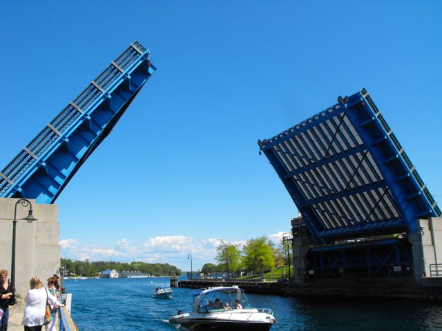
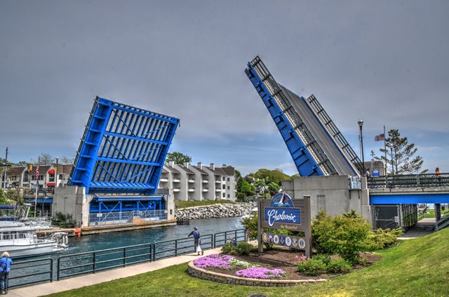
This bridge is a traditional movable bridge in Michigan: a deck plate girder bascule bridge that still operates frequently, usually for pleasure craft. Although the bridge superstructure retains good historic integrity, like most Michigan bascule bridges, the original railings have been destroyed. However, interestingly on this bridge, there is a design on the current railings that appears to have been based on the original railings of perhaps the bridge that existed before the bascule bridge. The railing design appears to simulate a rare and beautiful railing design that was used infrequently, but on a wide variety of bridge types in the late 19th and early 20th  century. The railing is inappropriate for this bridge, however, since this bridge would have originally had Michigan's traditional R4 style railings.

Sandra Bush contacted the website and found an error in the MDOT History: project engineer named as N. F. Kinney in their text is actually supposed to be N. F. McKinney, her grandfather. The text below has been corrected to this.

View Archived National Bridge Inventory Report - Has Additional Details and Evaluation

Information and Findings From Michigan Historic Bridge Inventory

Narrative Description

The double-leaf bascule bridge spans Island Lake Outlet, also known as the Pine River Channel. The channel, which was dredged in 1870, connects Lake Michigan to Lake Charlevoix via Round Lake, a popular harbor. The bridge carries US-31 (Bridge Street) in downtown Charlevoix.
The 44-foot steel-mesh roadway is flanked by six-foot sidewalks, which are cantilevered beyond the outer girders of the bascule. The metal-lattice replacement railings are somewhat more ornate than the original standard highway department metal panels, but are not a serious infringement on the integrity of the bridge's design. When closed, the bridge has an overhead clearance of 17 feet. Electric motors open the 45-foot leaves, providing a 90-foot channel. The machinery and casings that move the leaves weigh some 50 tons. The equipment is controlled from an operator's house at the bridge's southeast corner, with transformers in a vault on the east bank. Barriers rise from pockets in the pavement to stop vehicles from reaching the rising leaves. Gates and flashing signals also warn motorists that the bridge is opening. Facted concrete piers support the bascule leaves. The piers also support 40'-10" rolled-steel-beam approach spans with concrete roadways. The abutments are supported by thousands of cyprus pilings, while the bascule piers rest on steel piles.

This location has served as an important crossing for the area since at least 1869, when the first of a series of five bridges was erected here. The current bascule replaced a swing truss span built by the city in 1901. The new structure was designed by the state highway department bridge division, led by George M. Foster, and by prominent Chicago consulting engineers Haslett and Erdal, founded in 1936 as the successor to the Scherzer Rolling Lift Bridge Company, a pioneer in bascule design. Plans for the bridge were prepared in the early 1940s, but the project was delayed by World War II. In January 1947, the state highway department announced that it would open bids for erecting the bridge on 6 February. Five bids were submitted. The lowest, $697,981, was from contractors L.W. Lamb Company of Holland, Michigan, and the Luedtke Engineering Company of Frankfort, Michigan, who were awarded the contract for erecting the superstructure and substructure and building the detour roadway. The state purchased the fabricated steel from the Mt. Vernon Bridge Company of Mt. Vernon, Ohio, for $270,433. Work on the approaches was anticipated to cost an additional $46,500. The electrical contractor was Lake Shore Engineering Company of Iron Mountain, Michigan.

Luedtke Engineering's pile driver arrived in late May 1947, and preliminary work was soon underway. N. F. McKinney, project engineer for the state highway department, oversaw the project with district bridge engineer H.J. Conroy from Cadillac. In August, an old 123-foot swing-truss spans was towed across Lake Michigan from Sturgeon Bay, Wisconsin, for use as a detour. The north end of the truss was fixed to the river bank; the south end, floating on a pontoon could move to open the Pine River Channel for navigation.

By November, work was progressing on the north pier, and the coffer dam for the south pier was being set in place. The north pier was ready to receive its pair of steel bascule racks by March 1948, but the company had problems, however, casting the bronze-alloy trunnions. After two failed attempts, a set finally met the specification in September.

In the meantime, construction continued on the approaches and retaining walls. The assembled bascule girders arrived from Mt. Vernon in Octover, and workers rushed to install them before the onset of winter. The south leaf was assembled by early November, and attention then shifted to the north leaf. Bad weather and a labor shortage, compounded by the opening of deer hunting season, slowed progress towards the end of the month.

By January, 73 tons of concrete had been poured for the south counterweight, and crews were welding the steel-mesh deck on the south leaf. Work on the north counterweight followed. During the rest of the winter and into the spring, machinery was installed and other details were finished. The highway department approved plans for the transformer house, to the southeast of the bridge, in April.

The bridge was opened to traffic on 27 June, but it was not until 30 July that the structure was officially dedicated as a memorial to 22 local men who died during World War II. State Highway Commissioner Charles Ziegler used oversized wooden sheers to formally cut the ribbon to the bridge.


This bridge is tagged with the following special condition(s): Arch Lattice Railing and Unorganized Photos

Divider

Photo Galleries and Videos: Charlevoix Bridge


View Photo Gallery

Bridge Photo-Documentation

Original / Full Size Photos
A collection of overview and detail photos. This gallery offers photos in the highest available resolution and file size in a touch-friendly popup viewer.
Alternatively, Browse Without Using Viewer

Divider

View Photo Gallery

Bridge Photo-Documentation

Mobile Optimized Photos
A collection of overview and detail photos. This gallery features data-friendly, fast-loading photos in a touch-friendly popup viewer.
Alternatively, Browse Without Using Viewer

Divider

View Photo Gallery

2010-17 Additional Unorganized Photos

Original / Full Size Photos
A supplemental collection of photos that are from additional visit(s) to the bridge and have not been organized or captioned. This gallery offers photos in the highest available resolution and file size in a touch-friendly popup viewer.
Alternatively, Browse Without Using Viewer

Divider

View Photo Gallery

2010-17 Additional Unorganized Photos

Mobile Optimized Photos
A supplemental collection of photos that are from additional visit(s) to the bridge and have not been organized or captioned. This gallery features data-friendly, fast-loading photos in a touch-friendly popup viewer.
Alternatively, Browse Without Using Viewer

Divider

View Video

Bridge Being Raised

Full Motion Video
Streaming video of the bridge. Also includes a higher quality downloadable video for greater clarity or offline viewing.

Divider

Maps and Links: Charlevoix Bridge

Coordinates (Latitude, Longitude):

Search For Additional Bridge Listings:

Bridgehunter.com: View listed bridges within 0.5 miles (0.8 kilometers) of this bridge.

Bridgehunter.com: View listed bridges within 10 miles (16 kilometers) of this bridge.

HistoricBridges.org Bridge Browser: View listed bridges within 0.5 miles (0.8 kilometers) of this bridge.

HistoricBridges.org Bridge Browser: View listed bridges within 10 miles (16 kilometers) of this bridge.

2021 National Bridge Inventory: View listed bridges within 0.5 miles (0.8 kilometers) of this bridge.

Additional Maps:

Google Maps

Google Streetview (If Available)

Bing Maps

OpenStreetMap

GeoHack (Additional Links and Coordinates)

Apple Maps (Via DuckDuckGo Search)

Apple Maps (Apple devices only)

MapQuest

HERE We Go Maps

ACME Mapper

Waze Map

Android: Open Location In Your Map or GPS App

Flickr Gallery (Find Nearby Photos)

Wikimedia Commons (Find Nearby Photos)

Directions Via Sygic For Android

Directions Via Sygic For iOS and Android Dolphin Browser

USGS National Map (United States Only)

Historical USGS Topo Maps (United States Only)

Historic Aerials (United States Only)

CalTopo Maps (United States Only)


Divider
 
Home Top

Divider

About - Contact

© Copyright 2003-2024, HistoricBridges.org. All Rights Reserved. Disclaimer: HistoricBridges.org is a volunteer group of private citizens. HistoricBridges.org is NOT a government agency, does not represent or work with any governmental agencies, nor is it in any way associated with any government agency or any non-profit organization. While we strive for accuracy in our factual content, HistoricBridges.org offers no guarantee of accuracy. Information is provided "as is" without warranty of any kind, either expressed or implied. Information could include technical inaccuracies or errors of omission. Opinions and commentary are the opinions of the respective HistoricBridges.org member who made them and do not necessarily represent the views of anyone else, including any outside photographers whose images may appear on the page in which the commentary appears. HistoricBridges.org does not bear any responsibility for any consequences resulting from the use of this or any other HistoricBridges.org information. Owners and users of bridges have the responsibility of correctly following all applicable laws, rules, and regulations, regardless of any HistoricBridges.org information.

Admin Login

Divider