

View Information About HSR Ratings

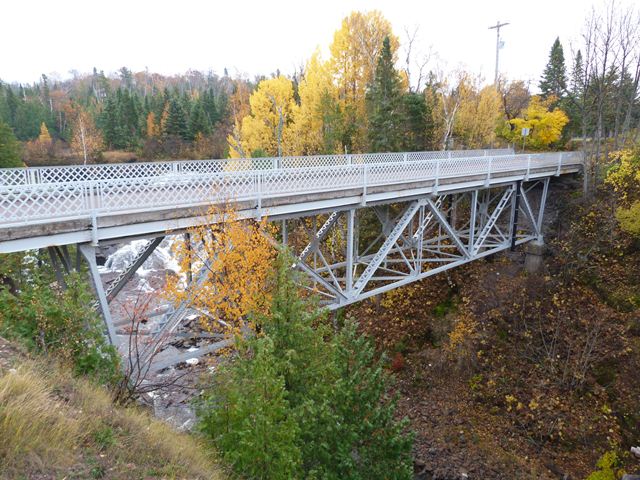
Michigan has very few remaining highway deck truss bridges, and as such this bridge is a rare surviving example. The bridge is also noted for its lack of alteration. The bridge retains original lattice railings. Despite some bolted repairs to the trusses, the bridge retains its original design and appearance. The bridge crosses a small but steep gorge of Eagle River next to an attractive waterfall. The bridge has been bypassed by a modern bridge, but the historic bridge was preserved for pedestrian use. The bridge is part of a roadside park that also offers views of the adjacent waterfall. The bridge thus still serves a useful function, since the waterfall is best viewed from the historic bridge.
The bridge's original plaques remain on the bridge. The obvious ones are the fabricator plaques mounted on the lattice railings of the bridge. However, careful observers will also find the bronze Michigan State Highway Department Standard plaques which credit the substructure contractor for the bridge, located on the outward facing sides of the piers for the bridge. It is not known who decided to put those plaques there and why, but it is perhaps the dumbest place to put plaques. They are in a location that nobody can safely view them without climbing gear! One wonders why anyone would bother spending the time and money to produce the plaques if they were to be placed somewhere that nobody would see them.
The interpretive signage for this bridge states that the bridge replaced a through truss bridge. The historical photo to the right is believed to be that previous bridge.
Information and Findings From Michigan Historic Sites OnlineNarrative Description The Lake Shore Drive Bridge, commonly known as the M-26 Bridge, crosses the Eagle River in the heart of the town of Eagle River within the boundaries of the Eagle River National Register District. The structure is a steel-riveted Warren deck truss bridge, consisting of three spans anchored into concrete abutments. The eighteen-foot-wide bridge consists of a one hundred and five-foot-long main span and two flanking spans thirty-four feet long to the deck, creating a total length of one hundred and thirty-nine feet. The structure's guard rails are woven steel lattice. Statement of Significance The Lake Shore Drive Bridge was erected in 1915 by the Wisconsin Bridge and Iron Company from designs furnished by the Michigan State Highway Department. The department was established in 1905 under the State Reward Law, which also provided financial aid to local government units for road construction to specific state standards. Michigan became a nationally-recognized leader in standardized bridge plans, used in the state trunk system and supplied upon request to local governments building bridges without state funds. The State Trunk Line Act of 1913 designated a road system of 3,000 miles and offered additional funding for localities. The Lake Shore Drive bridge served as a major transportation artery for the town of Eagle River until recent times. The bridge will be closed to vehicular traffic and rehabilitated for non-motorized use by the Michigan Department of Transportation. The Lake Shore Drive Bridge is an excellent example of a steel deck truss bridge, one of the three surviving historic bridges of its type defined in the Michigan Department of Transportation's "Historic Bridge Report." It is an early example of state assistance to local governments in developing and improving the state transportation network. Marker Text LAKE SHORE DRIVE BRIDGE |
![]()
![]()
![]()
Coordinates (Latitude, Longitude):
Search For Additional Bridge Listings:
Bridgehunter.com: View listed bridges within 0.5 miles (0.8 kilometers) of this bridge.
Bridgehunter.com: View listed bridges within 10 miles (16 kilometers) of this bridge.
Additional Maps:
Google Streetview (If Available)
GeoHack (Additional Links and Coordinates)
Apple Maps (Via DuckDuckGo Search)
Apple Maps (Apple devices only)
Android: Open Location In Your Map or GPS App
Flickr Gallery (Find Nearby Photos)
Wikimedia Commons (Find Nearby Photos)
Directions Via Sygic For Android
Directions Via Sygic For iOS and Android Dolphin Browser
USGS National Map (United States Only)
Historical USGS Topo Maps (United States Only)
Historic Aerials (United States Only)
CalTopo Maps (United States Only)

© Copyright 2003-2024, HistoricBridges.org. All Rights Reserved. Disclaimer: HistoricBridges.org is a volunteer group of private citizens. HistoricBridges.org is NOT a government agency, does not represent or work with any governmental agencies, nor is it in any way associated with any government agency or any non-profit organization. While we strive for accuracy in our factual content, HistoricBridges.org offers no guarantee of accuracy. Information is provided "as is" without warranty of any kind, either expressed or implied. Information could include technical inaccuracies or errors of omission. Opinions and commentary are the opinions of the respective HistoricBridges.org member who made them and do not necessarily represent the views of anyone else, including any outside photographers whose images may appear on the page in which the commentary appears. HistoricBridges.org does not bear any responsibility for any consequences resulting from the use of this or any other HistoricBridges.org information. Owners and users of bridges have the responsibility of correctly following all applicable laws, rules, and regulations, regardless of any HistoricBridges.org information.
![]()