

View Information About HSR Ratings
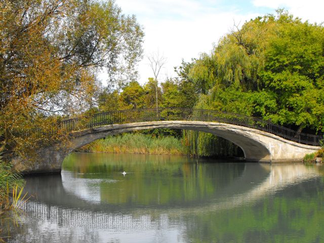
Elizabeth Park has three beautiful arch bridges that are all identical, and all carry pedestrians over the canal that runs through the park. One is located at the northeastern part of the park near where the canal enters the Detroit River. Another is located in the northwest portion of the park. The third, which is closed to traffic after a section of railing fell off the bridge, is located in the southwestern part of the park near to the parking lot off of Jefferson Avenue in that portion of the park.
These graceful bridges are all extremely attractive due to their amazingly slim profile which almost seems to defy gravity as they rise up and over the canal. In addition, ornate metal railings add greatly to the aesthetic value of these structures.
The bridges have been identified as potentially eligible for the National Register of Historic Places, and were built between 1924 and 1930. The park they sit in is historically significant as Michigan's first county park. Thus, the bridges should not only be individually historically significant, but they are a contributing elements of a historic park. Despite this, the county has chosen to demolish and replace all three of these bridges, claiming they are all beyond repair. Each of the three bridges displays different levels and forms of deterioration. The bridge at the northeastern corner of the park for example overall seems to be in good condition generally, but a closer look reveals widespread cracking and efflorescence, which could indicate the bridge is indeed beyond repair. The southern bridge has significant spalling on the deck surface and is missing a section of railing. The western bridge has some deck spalling, but it only shows cracking and efflorescence on the edges of the arch, unlike the northeastern corner bridge.
Giving the county the benefit of the doubt in terms of the determination that the bridges are beyond repair, how should the bridges be dealt with? It is not acceptable to lose the heritage and beauty that historic concrete bridges offer just because the bridges have been neglected to the point which repair is impossible. Therefore, HistoricBridges.org believes the bridges should be replicated. However the word "replicate" is often used incorrectly by modern engineers and bridge owners. For example, some engineers and perhaps Wayne County would argue that their plan for the bridges does involve replicating them. They plan to demolish the historic bridge superstructures and reuse the abutments to hold replacement arches. The replacement arches will retain the step design on the deck, the same arch rise, and the same railing design. However, the plan falls very short of being an example of historic bridge replication, because one of the most important aspects of the historic bridge, the smooth elliptical curve, will be replaced with a more uniformly curved arch that terminates abruptly at the abutment. This will vastly change the visual appearance of the bridge, and therefore make the replacement bridges impossible for future park visitors to use for interpretation and understanding of the historic bridges that the new bridges replaced. The historic bridges display an elliptical arch, where the replacements have the appearance of a segmental arch. This is a fundamental difference in the design and appearance of the bridge. Further, it is worth mentioning that if a historic concrete bridge is to be replicated, special concrete formliners should be used which would simulate the texture of the wooden planks that were used in historic times.
Information and Findings From Army Corp of EngineersDiscussion of Bridge and Park A review of existing information revealed that the
three (3) foot bridges were constructed in Elizabeth The District Engineer has made an initial
determination that the three (3) pedestrian bridges, despite |
![]()
![]()
![]()

![]()
![]()
This historic bridge has been demolished. This map is shown for reference purposes only.
Coordinates (Latitude, Longitude):
Search For Additional Bridge Listings:
Bridgehunter.com: View listed bridges within 0.5 miles (0.8 kilometers) of this bridge.
Bridgehunter.com: View listed bridges within 10 miles (16 kilometers) of this bridge.
Additional Maps:
Google Streetview (If Available)
GeoHack (Additional Links and Coordinates)
Apple Maps (Via DuckDuckGo Search)
Apple Maps (Apple devices only)
Android: Open Location In Your Map or GPS App
Flickr Gallery (Find Nearby Photos)
Wikimedia Commons (Find Nearby Photos)
Directions Via Sygic For Android
Directions Via Sygic For iOS and Android Dolphin Browser
USGS National Map (United States Only)
Historical USGS Topo Maps (United States Only)
Historic Aerials (United States Only)
CalTopo Maps (United States Only)

© Copyright 2003-2024, HistoricBridges.org. All Rights Reserved. Disclaimer: HistoricBridges.org is a volunteer group of private citizens. HistoricBridges.org is NOT a government agency, does not represent or work with any governmental agencies, nor is it in any way associated with any government agency or any non-profit organization. While we strive for accuracy in our factual content, HistoricBridges.org offers no guarantee of accuracy. Information is provided "as is" without warranty of any kind, either expressed or implied. Information could include technical inaccuracies or errors of omission. Opinions and commentary are the opinions of the respective HistoricBridges.org member who made them and do not necessarily represent the views of anyone else, including any outside photographers whose images may appear on the page in which the commentary appears. HistoricBridges.org does not bear any responsibility for any consequences resulting from the use of this or any other HistoricBridges.org information. Owners and users of bridges have the responsibility of correctly following all applicable laws, rules, and regulations, regardless of any HistoricBridges.org information.
![]()