HistoricBridges.org Menu: HistoricBridges.org Menu:


We Recommend:
Bach Steel - Experts at historic truss bridge restoration.

HistoricBridges.org: Bridge Browser

Grant Road Bridge

Grant Road Bridge

Primary Photographer(s): Nathan Holth

Bridge Documented: Winter 2006, March 15, 2009, and November 13, 2021

View Photos
and Videos
View Maps
and Links

Facility Carried / Feature Intersected
Grant Road Over Pine Creek
Location
Rural: Gratiot County, Michigan: United States
Construction Date and Builder / Engineer
1927 By Builder/Contractor: Unknown and Engineer/Design: Michigan State Highway Department
Rehabilitation Date
Not Available or Not Applicable
Main Span Length
54.8 Feet (16.7 Meters)
Structure Length
60.0 Feet (18.3 Meters)
Roadway Width
7 Feet (2.13 Meters)
Spans
1 Main Span(s)
Inventory Number
29200009000B020

Historic Significance Rating (HSR)
View Information About HSR Ratings

Bridge Documentation

View Archived National Bridge Inventory Report - Has Additional Details and Evaluation

Learn about Michigan's Unique Concrete Camelback Bridges

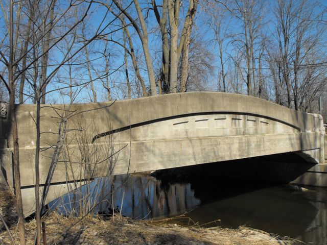
Although each remaining example of this rare structure type, is highly rare on a statewide level, and spans of 60 feet or longer are significant even on a national level, these bridges receive little attention and are being demolished regardless of their value. These bridges are examples of Michigan's leadership in the early years of 20th century bridge design standardization. These bridges were designed to be beautiful, functional, and long-lived. They certainly have been long lived. They have so much reinforced concrete supporting them, that they are demolished less often for their structural deficiency than for their narrow two-lane deck width. This bridge is however on a quiet paved road, and as such, its deck width is effective and safe. It would be a great candidate for restoration.


This bridge is tagged with the following special condition(s): Unorganized Photos

Divider

Photo Galleries and Videos: Grant Road Bridge


View Photo Gallery

2009 Bridge Photo-Documentation

Original / Full Size Photos
A collection of overview and detail photos, taken March 15, 2009. This gallery offers photos in the highest available resolution and file size in a touch-friendly popup viewer.
Alternatively, Browse Without Using Viewer

Divider

View Photo Gallery

2009 Bridge Photo-Documentation

Mobile Optimized Photos
A collection of overview and detail photos, taken March 15, 2009. This gallery features data-friendly, fast-loading photos in a touch-friendly popup viewer.
Alternatively, Browse Without Using Viewer

Divider

View Photo Gallery

Winter 2006 Bridge Photo-Documentation

A collection of overview and detail photos, taken Winter 2006. This photo gallery contains a combination of Original Size photos and Mobile Optimized photos in a touch-friendly popup viewer.
Alternatively, Browse Without Using Viewer

Divider

View Photo Gallery

Additional Unorganized Photos

Original / Full Size Photos
A supplemental collection of photos that are from additional visit(s) to the bridge and have not been organized or captioned. This gallery offers photos in the highest available resolution and file size in a touch-friendly popup viewer.
Alternatively, Browse Without Using Viewer

Divider

View Photo Gallery

Additional Unorganized Photos

Mobile Optimized Photos
A supplemental collection of photos that are from additional visit(s) to the bridge and have not been organized or captioned. This gallery features data-friendly, fast-loading photos in a touch-friendly popup viewer.
Alternatively, Browse Without Using Viewer

Divider

Maps and Links: Grant Road Bridge

Coordinates (Latitude, Longitude):

Search For Additional Bridge Listings:

Bridgehunter.com: View listed bridges within 0.5 miles (0.8 kilometers) of this bridge.

Bridgehunter.com: View listed bridges within 10 miles (16 kilometers) of this bridge.

HistoricBridges.org Bridge Browser: View listed bridges within 0.5 miles (0.8 kilometers) of this bridge.

HistoricBridges.org Bridge Browser: View listed bridges within 10 miles (16 kilometers) of this bridge.

2021 National Bridge Inventory: View listed bridges within 0.5 miles (0.8 kilometers) of this bridge.

Additional Maps:

Google Maps

Google Streetview (If Available)

Bing Maps

OpenStreetMap

GeoHack (Additional Links and Coordinates)

Apple Maps (Via DuckDuckGo Search)

Apple Maps (Apple devices only)

MapQuest

HERE We Go Maps

ACME Mapper

Waze Map

Android: Open Location In Your Map or GPS App

Flickr Gallery (Find Nearby Photos)

Wikimedia Commons (Find Nearby Photos)

Directions Via Sygic For Android

Directions Via Sygic For iOS and Android Dolphin Browser

USGS National Map (United States Only)

Historical USGS Topo Maps (United States Only)

Historic Aerials (United States Only)

CalTopo Maps (United States Only)


Divider
 
Home Top

Divider

About - Contact

© Copyright 2003-2024, HistoricBridges.org. All Rights Reserved. Disclaimer: HistoricBridges.org is a volunteer group of private citizens. HistoricBridges.org is NOT a government agency, does not represent or work with any governmental agencies, nor is it in any way associated with any government agency or any non-profit organization. While we strive for accuracy in our factual content, HistoricBridges.org offers no guarantee of accuracy. Information is provided "as is" without warranty of any kind, either expressed or implied. Information could include technical inaccuracies or errors of omission. Opinions and commentary are the opinions of the respective HistoricBridges.org member who made them and do not necessarily represent the views of anyone else, including any outside photographers whose images may appear on the page in which the commentary appears. HistoricBridges.org does not bear any responsibility for any consequences resulting from the use of this or any other HistoricBridges.org information. Owners and users of bridges have the responsibility of correctly following all applicable laws, rules, and regulations, regardless of any HistoricBridges.org information.

Admin Login

Divider