

View Information About HSR Ratings
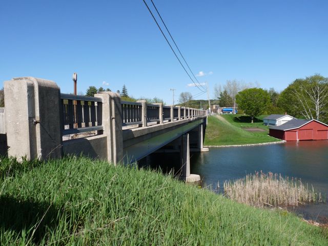
There are only seven on-system vehicular bridges in the entirety of Leelanau County, and this is the only one with historic significance. The bridge actually has enough significance that the bridge is even listed on the National Register of Historic Places. Although a common structure type, the bridge retains excellent historic integrity and it is significant for its association with Depression-era funding programs and also with the development of the tourism industry in Michigan. The bridge retains its plaques and original R4 guardrails. The concrete posts on the guardrail system differ from the usual posts employed when the R4 metal panels are present on a bridge.
Information and Findings From Michigan Historic Sites OnlineNarrative Description Long and narrow Lake Leelanau, a popular tourist destination stretches over fifteen miles from north to south. The lake is divided into two sections, with the smaller part to the north. The sections are connected by a channel, the "Narrows," which is crossed by the three-span M-204 Bridge. Each span consists of nine rolled steel beams. The bridge ends skewed, but the concrete piers are perpendicular to the centerline. The pier bases, which support four square-section concrete posts, form pointed cutwaters at each end. The pier posts have notched corners, and the tops of the outside posts terminate in a graceful streamline Modern curve. A similar motif appears on the concrete posts holding the metal railing panels, which are of a standard highway department design. Modern metal guard rail is attached to the railing ends. Narrow sidewalks run between the railings and the roadway. The deck is 38 feet wide. Statement of Significance The Lake Leelanau Narrows Bridge is eligible for the National Register as a significant product of a Depression-era relief program and a reflection of the influence of the tourism industry on highway development. French Canadian farmers settled in this area in the mid-1800s. Lake Leelanau, an obstruction to east-west travel, was first spanned by a wooden bridge in 1864. This was replaced by a metal truss bridge in 1894-1895, which served traffic until the Michigan State Highway Department built the existing structure in 1939. The new bridge was sited about 200 yards north of the previous span. The Lake Leelanau Narrows Bridge was a project of the Federal Emergency Administration of Public Works, which sought both to improve the nation's infrastructure and to put those unemployed by the Depression back to work. A special guest at the dedication of the bridge in December 1939 was State Highway Commissioner G. Donald Kennedy. His speech emphasized the key role tourism played in the area's economy, and the necessity of developing good highways to access the area's natural assets: "You have one of the most beautiful counties in the state. You are near the second largest city in the nation -- Chicago. You need good roads to join this marvelous recreation land with the millions who swelter in Chicago's heat in the summer time and are looking for winter sports at this season of the year." The bridge exemplifies the impact of Depression-era programs, which not only provided work for the unemployed, but also created long-lasting improvements serving other purposes, such as tourism. The Lake Leelanau Narrows Bridge is a significant product of a Depression-era relief program, and reflects the influence of the tourism industry on highway development. It is eligible for the National Register under Criterion A. |
![]()
![]()
![]()
Coordinates (Latitude, Longitude):
Search For Additional Bridge Listings:
Bridgehunter.com: View listed bridges within 0.5 miles (0.8 kilometers) of this bridge.
Bridgehunter.com: View listed bridges within 10 miles (16 kilometers) of this bridge.
Additional Maps:
Google Streetview (If Available)
GeoHack (Additional Links and Coordinates)
Apple Maps (Via DuckDuckGo Search)
Apple Maps (Apple devices only)
Android: Open Location In Your Map or GPS App
Flickr Gallery (Find Nearby Photos)
Wikimedia Commons (Find Nearby Photos)
Directions Via Sygic For Android
Directions Via Sygic For iOS and Android Dolphin Browser
USGS National Map (United States Only)
Historical USGS Topo Maps (United States Only)
Historic Aerials (United States Only)
CalTopo Maps (United States Only)

© Copyright 2003-2024, HistoricBridges.org. All Rights Reserved. Disclaimer: HistoricBridges.org is a volunteer group of private citizens. HistoricBridges.org is NOT a government agency, does not represent or work with any governmental agencies, nor is it in any way associated with any government agency or any non-profit organization. While we strive for accuracy in our factual content, HistoricBridges.org offers no guarantee of accuracy. Information is provided "as is" without warranty of any kind, either expressed or implied. Information could include technical inaccuracies or errors of omission. Opinions and commentary are the opinions of the respective HistoricBridges.org member who made them and do not necessarily represent the views of anyone else, including any outside photographers whose images may appear on the page in which the commentary appears. HistoricBridges.org does not bear any responsibility for any consequences resulting from the use of this or any other HistoricBridges.org information. Owners and users of bridges have the responsibility of correctly following all applicable laws, rules, and regulations, regardless of any HistoricBridges.org information.
![]()