

View Information About HSR Ratings
This bridge has a plaque on it listing a 1914 construction date.
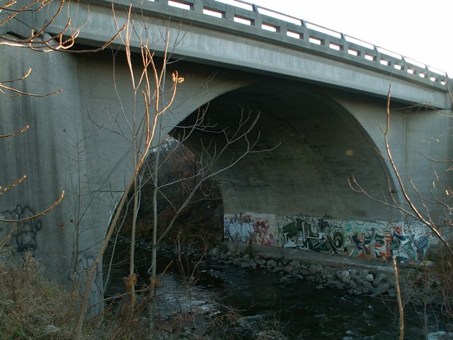
This bridge's arch has much more vertical clearance than the other Flint arch bridges, and is quite an impressive structure to view. In the 1960s, the bridge had its railings replaced, and it was widened by adding standard pre-stressed concrete beams to the outside of the bridge. These modifications seriously diminished the structure's beauty and historic integrity. However, the bridge may become increasingly important as Flint demolishes its remaining arch bridges one by one. There is a large crack in one part of the abutment, but otherwise the bridge structure appears to be in pristine physical condition, quite a change from the other Flint bridges. Perhaps MDOT has done a better job maintaining the bridge than the other city-owned bridges.
This bridge is the remains of the West Court Street Viaduct. The West Court Street Viaduct consisted of this bridge over the creek (at that time, this section of the creek was apparently considered part of Thread Creek rather than Swartz Creek) and a beam bridge over the railroad a short distance east of the arch bridge. These two structures, although structurally separated by a section of built-up land, were visually united by a beautiful concrete balustrade railing system that continued on the raised section of roadway between the two bridge structures. The structure was featured in the 1920 City Plan as seen in the illustration to the right.

![]()
![]()
![]()
Coordinates (Latitude, Longitude):
Search For Additional Bridge Listings:
Bridgehunter.com: View listed bridges within 0.5 miles (0.8 kilometers) of this bridge.
Bridgehunter.com: View listed bridges within 10 miles (16 kilometers) of this bridge.
Additional Maps:
Google Streetview (If Available)
GeoHack (Additional Links and Coordinates)
Apple Maps (Via DuckDuckGo Search)
Apple Maps (Apple devices only)
Android: Open Location In Your Map or GPS App
Flickr Gallery (Find Nearby Photos)
Wikimedia Commons (Find Nearby Photos)
Directions Via Sygic For Android
Directions Via Sygic For iOS and Android Dolphin Browser
USGS National Map (United States Only)
Historical USGS Topo Maps (United States Only)
Historic Aerials (United States Only)
CalTopo Maps (United States Only)

© Copyright 2003-2024, HistoricBridges.org. All Rights Reserved. Disclaimer: HistoricBridges.org is a volunteer group of private citizens. HistoricBridges.org is NOT a government agency, does not represent or work with any governmental agencies, nor is it in any way associated with any government agency or any non-profit organization. While we strive for accuracy in our factual content, HistoricBridges.org offers no guarantee of accuracy. Information is provided "as is" without warranty of any kind, either expressed or implied. Information could include technical inaccuracies or errors of omission. Opinions and commentary are the opinions of the respective HistoricBridges.org member who made them and do not necessarily represent the views of anyone else, including any outside photographers whose images may appear on the page in which the commentary appears. HistoricBridges.org does not bear any responsibility for any consequences resulting from the use of this or any other HistoricBridges.org information. Owners and users of bridges have the responsibility of correctly following all applicable laws, rules, and regulations, regardless of any HistoricBridges.org information.
![]()