

View Information About HSR Ratings
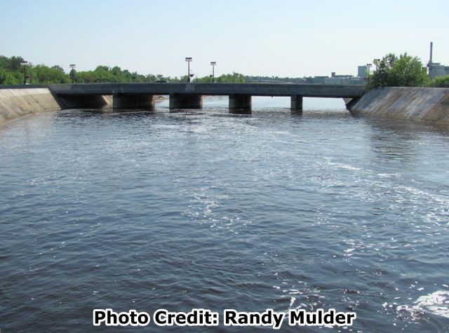
This bridge crosses the Manistique River, as well as the Manistique River flume which is like a concrete river channel that is positioned higher than the actual river to allow water to flow at a higher elevation from a dam upstream. This flume was a solution to a paper mill's need for more water for its mill. A dam there would have been unacceptable since it would have flooded the town. The portion of the bridge that crossed over the flume was specially designed with thick, tall railings similar to those used by the state highway department for through girders. In this case however, the railings actually protected the roadway from water, which originally flowed at a level higher than the roadway itself. This unusual function is no longer visible, since the mill had lowered the water level below that of the roadway in recent years.
Paul Walker of the Schoolcraft County Historical Society reported that as of 2013, Manistique Papers remains in business and is owned by Future-Mark Papers. Currently the mill has been hiring and doing quite well giving the difficulty of the paper industry. Governor Snyder and State Senator Tom Casperson and a local bank, M-Bank are very much credited for saving the Paper Mill utilizing assets from the Michigan Economic Development Corporation to back up loans until the mill was sold and emerged from bankruptcy.
The portion of the bridge itself which crosses over the actual river rather than the flume appears to have been extensively reconstructed, and may have a loss of historic integrity.


Information and Findings From Michigan Historic Bridge InventoryNarrative Description This eight-span girder bridge is 296 feet long overall and is an unusual design in that the bridge is an integral part of a concrete raceway flume. Since the water level in the flume is actually above the level of the roadway, the bridge acts as a siphon, thus its nickname, Siphon Bridge. |
![]()
![]()
![]()
Coordinates (Latitude, Longitude):
Search For Additional Bridge Listings:
Bridgehunter.com: View listed bridges within 0.5 miles (0.8 kilometers) of this bridge.
Bridgehunter.com: View listed bridges within 10 miles (16 kilometers) of this bridge.
Additional Maps:
Google Streetview (If Available)
GeoHack (Additional Links and Coordinates)
Apple Maps (Via DuckDuckGo Search)
Apple Maps (Apple devices only)
Android: Open Location In Your Map or GPS App
Flickr Gallery (Find Nearby Photos)
Wikimedia Commons (Find Nearby Photos)
Directions Via Sygic For Android
Directions Via Sygic For iOS and Android Dolphin Browser
USGS National Map (United States Only)
Historical USGS Topo Maps (United States Only)
Historic Aerials (United States Only)
CalTopo Maps (United States Only)

© Copyright 2003-2024, HistoricBridges.org. All Rights Reserved. Disclaimer: HistoricBridges.org is a volunteer group of private citizens. HistoricBridges.org is NOT a government agency, does not represent or work with any governmental agencies, nor is it in any way associated with any government agency or any non-profit organization. While we strive for accuracy in our factual content, HistoricBridges.org offers no guarantee of accuracy. Information is provided "as is" without warranty of any kind, either expressed or implied. Information could include technical inaccuracies or errors of omission. Opinions and commentary are the opinions of the respective HistoricBridges.org member who made them and do not necessarily represent the views of anyone else, including any outside photographers whose images may appear on the page in which the commentary appears. HistoricBridges.org does not bear any responsibility for any consequences resulting from the use of this or any other HistoricBridges.org information. Owners and users of bridges have the responsibility of correctly following all applicable laws, rules, and regulations, regardless of any HistoricBridges.org information.
![]()