

View Information About HSR Ratings

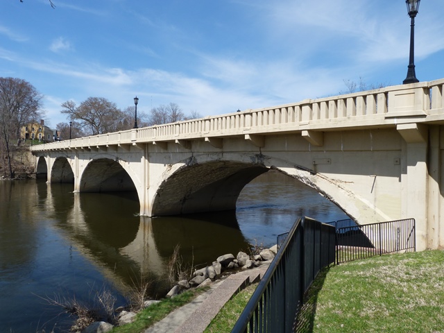
This bridge, together with the Niles Railroad Bridge, create a unique river scene in Niles that adds a lot of beauty to the city. A river walk passes under this bridge, so it is easy to visit this bridge and many people get to enjoy viewing this bridge during their walks. This bridge is slightly inclined (ie constructed with a grade), and so the arches are taller at the western end of the bridge.
This deck arch bridge has a coat of protective paint on it, however, it does not appear that any work was done to the structure prior to paint application. As such, the paint may deceive casual viewers that this bridge is in good condition and has been taken care of. This is not the case, as there is considerable cracking and spalling on the arches. The railings on the bridge are not original, although their unusual balustrade-like design might trick casual viewers into thinking they are original.
This bridge is to be demolished and replaced. As of 2014, the Section 106 Review was complete. MDOT said the reason this historic bridge could not be rehabilitated was because it was built on spread footings and that these had deteriorated and had a scour issue, and that they could not be repaired or replaced without essentially destroying the rest of the bridge in the effort. This is quite interesting, because just south of this bridge across the state line in Indiana there are a bunch of historic concrete arch bridges crossing the St. Joseph River, and nearly all of them have been beautifully preserved and rehabilitated. Apparently, the Indiana bridges were either built without spread footings, with better spread footings, or they were maintained better by Indiana this Michigan bridge was, and never developed the same level of deterioration. Whatever the case, it was nice to have a Michigan arch bridge to compare to the Indiana bridges, and the demolition of this bridge will eliminate that opportunity. Its very disappointing that this bridge will not be preserved.
Information and Findings From Michigan Historic Bridge InventoryNarrative Description This is the fourth largest earth-filled concrete arch bridge known to survive in Michigan, with an overall length of 338 feet. It is located on US-12 over the St. Joseph River in Berrien County. |
This bridge is tagged with the following special condition(s): Unorganized Photos
![]()
![]()
![]()
![]()
![]()
This historic bridge has been demolished. This map is shown for reference purposes only.
Coordinates (Latitude, Longitude):
Search For Additional Bridge Listings:
Bridgehunter.com: View listed bridges within 0.5 miles (0.8 kilometers) of this bridge.
Bridgehunter.com: View listed bridges within 10 miles (16 kilometers) of this bridge.
Additional Maps:
Google Streetview (If Available)
GeoHack (Additional Links and Coordinates)
Apple Maps (Via DuckDuckGo Search)
Apple Maps (Apple devices only)
Android: Open Location In Your Map or GPS App
Flickr Gallery (Find Nearby Photos)
Wikimedia Commons (Find Nearby Photos)
Directions Via Sygic For Android
Directions Via Sygic For iOS and Android Dolphin Browser
USGS National Map (United States Only)
Historical USGS Topo Maps (United States Only)
Historic Aerials (United States Only)
CalTopo Maps (United States Only)

© Copyright 2003-2024, HistoricBridges.org. All Rights Reserved. Disclaimer: HistoricBridges.org is a volunteer group of private citizens. HistoricBridges.org is NOT a government agency, does not represent or work with any governmental agencies, nor is it in any way associated with any government agency or any non-profit organization. While we strive for accuracy in our factual content, HistoricBridges.org offers no guarantee of accuracy. Information is provided "as is" without warranty of any kind, either expressed or implied. Information could include technical inaccuracies or errors of omission. Opinions and commentary are the opinions of the respective HistoricBridges.org member who made them and do not necessarily represent the views of anyone else, including any outside photographers whose images may appear on the page in which the commentary appears. HistoricBridges.org does not bear any responsibility for any consequences resulting from the use of this or any other HistoricBridges.org information. Owners and users of bridges have the responsibility of correctly following all applicable laws, rules, and regulations, regardless of any HistoricBridges.org information.
![]()