

View Information About HSR Ratings
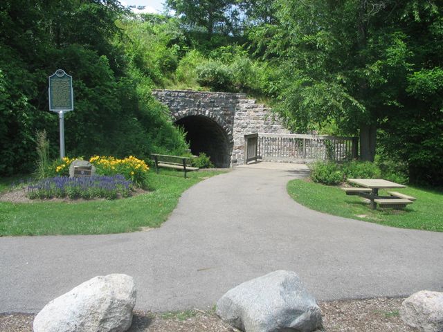
This is a crossing with a rather unusual history. In the late 1860s, the Grand Rapids and Indiana Railroad originally built a 560 foot long wooden "trestle" type of structure to cross the geographic feature called Porter Hollow through which Stegman Creek flows. As a wooden bridge, it was plagued by the typical problems such as flood damage, fire, etc. At one point in the mid-1880s, the railroad decided to build the stone arch which is seen today to repair a damaged section of the wooden trestle which passed over the creek. This might seem a rather unusual repair to make for a wooden bridge, but the railroad seems to have already had another step in mind. Some time after the stone arch was built, the railroad decided they wanted to have a dirt approach to the bridge rather than a trestle structure. Such an approach might take more work to construct, but would not require maintenance like a trestle. Rather than tear the old trestle out, which would have been a lot of work and inconvenient, they simply buried the trestle inside the dirt. So technically at least the remains of the trestle are probably still buried in the dirt. The new earthen embankment was apparently much longer than the trestle, since it is listed by Michigan Historic Sites Online as 1400 feet in length.
Both the stone arch bridge and the dirt embankment are listed on both the Michigan State Register of Historic Places and the National Register of Historic Places as a single structure. The structure is an excellent example of a listing in the National Register of Historic Places that was justified largely using local significance. With bridges, often local significance is not investigated when an agency or individual is considering the historic significance of a bridge and its potential eligibility for the National Register. This means that many bridges that are locally significant may not be recognized as historic bridges when in fact they should be. The structure is locally significant as a noteworthy pre-1900 engineering achievement, and the arch may be the oldest structure in the township. It is worth noting that the stone arch also has state level significance because it is an old, very well preserved, unaltered example of a stone arch bridge. Michigan does not have a lot of stone arch bridges so it is a rare bridge type in the state.
The stone arch today appears to be in immaculate condition. The stone work appears to have been maintained and/or restored. The bridge serves a functional purpsose by carrying a rail-trail. In addition, the bridge is the centerpiece in a park which is named Trestle Park. Interpretive signage is present for the bridge in the park. In addition there is a plaque indicating that the bridge is a Michigan Historic Civil Engineering Landmark.
An unusual feature at the bridge is that the bed of the creek has wooden planks lining it under the bridge. It is not known if this is an original feature or something added at a later date. However at the time this structure was added to HistoricBridges.org, of the nearly 2000 bridges listed on the website at the time, this stone arch bridge was the only structure on the website to have wooden planking lining the bottom of a river or creek under the bridge. In other words, it is something very unusual.
Information and Findings From Michigan Historic Sites OnlineNarrative Description The Porter Hollow Embankment and Culvert is an approximately 1400 foot long earthen structure with stone arch culvert that once carried a single track railroad line across Stegman Creek and Porter Hollow. The maximum height of the structure above Stegman Creek is about forty two feet. The arch of the cut fieldstone culvert structure is nineteen feet in width, seventy five feet in length through the embankment, and about nineteen feet high from normal water level to the top of the opening. Stonework rises about six feet above the top of the arch opening, and cut fieldstone wingwalls flank the creek beyond the culvert itself at each end. The blacktopped White Pine Trail, managed by the Department of Natural Resources, now crosses the embankment in place of the railroad line. Statement of Significance Constructed to span a steep sided valley or "hollow," an unusual topographical feature in southern Michigan's typically sedate countryside, the Porter Hollow Embankment and Culvert is an impressive piece of railroad engineering both for its overall dimensions of length and height and for its stone arch culvert. The embankment and culvert were constructed for the Grand Rapids and Indiana Railroad in the 1883-85 period after a flood in 1883 and three fires damaged or destroyed previous wooden trestle structures at the site. Marker Text Grand Rapids and Indiana Railroad Culvert: The Grand Rapids and Indiana Railroad (GR&I) reached Algoma Township in 1867. A series of wooden trestles were built to cross Wicked Creek, later named Stegman Creek. In 1885, after repeated fires and floods, the GR&I hired James House to cut fieldstones from his farm and build this culvert to stabilize the trestle. Eventually, the GR&I abandoned the trestle and buried it intact within a wall of dirt above the culvert. |
![]()
![]()
![]()
Coordinates (Latitude, Longitude):
Search For Additional Bridge Listings:
Bridgehunter.com: View listed bridges within 0.5 miles (0.8 kilometers) of this bridge.
Bridgehunter.com: View listed bridges within 10 miles (16 kilometers) of this bridge.
Additional Maps:
Google Streetview (If Available)
GeoHack (Additional Links and Coordinates)
Apple Maps (Via DuckDuckGo Search)
Apple Maps (Apple devices only)
Android: Open Location In Your Map or GPS App
Flickr Gallery (Find Nearby Photos)
Wikimedia Commons (Find Nearby Photos)
Directions Via Sygic For Android
Directions Via Sygic For iOS and Android Dolphin Browser
USGS National Map (United States Only)
Historical USGS Topo Maps (United States Only)
Historic Aerials (United States Only)
CalTopo Maps (United States Only)

© Copyright 2003-2024, HistoricBridges.org. All Rights Reserved. Disclaimer: HistoricBridges.org is a volunteer group of private citizens. HistoricBridges.org is NOT a government agency, does not represent or work with any governmental agencies, nor is it in any way associated with any government agency or any non-profit organization. While we strive for accuracy in our factual content, HistoricBridges.org offers no guarantee of accuracy. Information is provided "as is" without warranty of any kind, either expressed or implied. Information could include technical inaccuracies or errors of omission. Opinions and commentary are the opinions of the respective HistoricBridges.org member who made them and do not necessarily represent the views of anyone else, including any outside photographers whose images may appear on the page in which the commentary appears. HistoricBridges.org does not bear any responsibility for any consequences resulting from the use of this or any other HistoricBridges.org information. Owners and users of bridges have the responsibility of correctly following all applicable laws, rules, and regulations, regardless of any HistoricBridges.org information.
![]()