

View Information About HSR Ratings
This bridge is on privately owned vacant land that was up for auction at the time HistoricBridges.org documented the bridge. The auction allowed for public access to the bridge. This bridge is locally significant as one of only two known remaining truss bridges in Barry County. The bridge connects a section of open land to a heavily wooded and undeveloped section of land. There is no real trail or path of any kind on the wooded side. It is likely this bridge was moved here by a private owner. The bridge may have been originally been on a public road.
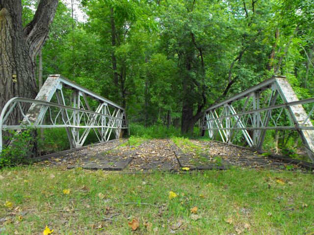
This bridge is a five panel half-hip Pratt pony truss with riveted connections that likely dates to between 1900 and 1915. The bridge is traditionally composed except for the railings which have a v-lacing pattern rather than a more typical lattice pattern. The bridge has paint on it, although it appears to have been applied only after significant pack rust had developed on the top chord cover plate. Otherwise however the majority of the truss appears to be in good condition. There are do not appear to be any major alterations to the truss structure. The deck is a traditional wooden deck with running boards. The deck wood is largely in place and complete, but appears to be slowly rotting, with plants starting to grow in it.
The bridge sits on a simple wooden crib structure. This structure has been washed out quite a bit by water and the wood is rotting. It is an unstable substructure and it could eventually compromise the good condition of the truss. Reconstruction of the substructure is suggested for the owner of the bridge. The other primary area of concern is that the bridge has sat in this position untended long enough that small trees have grown into truss members in a couple locations. Removal of these trees would be recommended for any owner of this bridge.
![]()
![]()
![]()
This bridge is on a private road and is private property. It is not visible from any public road. It may be possible to reach the bridge legally using water craft like a canoe.
Coordinates (Latitude, Longitude):
Search For Additional Bridge Listings:
Bridgehunter.com: View listed bridges within 0.5 miles (0.8 kilometers) of this bridge.
Bridgehunter.com: View listed bridges within 10 miles (16 kilometers) of this bridge.
Additional Maps:
Google Streetview (If Available)
GeoHack (Additional Links and Coordinates)
Apple Maps (Via DuckDuckGo Search)
Apple Maps (Apple devices only)
Android: Open Location In Your Map or GPS App
Flickr Gallery (Find Nearby Photos)
Wikimedia Commons (Find Nearby Photos)
Directions Via Sygic For Android
Directions Via Sygic For iOS and Android Dolphin Browser
USGS National Map (United States Only)
Historical USGS Topo Maps (United States Only)
Historic Aerials (United States Only)
CalTopo Maps (United States Only)

© Copyright 2003-2024, HistoricBridges.org. All Rights Reserved. Disclaimer: HistoricBridges.org is a volunteer group of private citizens. HistoricBridges.org is NOT a government agency, does not represent or work with any governmental agencies, nor is it in any way associated with any government agency or any non-profit organization. While we strive for accuracy in our factual content, HistoricBridges.org offers no guarantee of accuracy. Information is provided "as is" without warranty of any kind, either expressed or implied. Information could include technical inaccuracies or errors of omission. Opinions and commentary are the opinions of the respective HistoricBridges.org member who made them and do not necessarily represent the views of anyone else, including any outside photographers whose images may appear on the page in which the commentary appears. HistoricBridges.org does not bear any responsibility for any consequences resulting from the use of this or any other HistoricBridges.org information. Owners and users of bridges have the responsibility of correctly following all applicable laws, rules, and regulations, regardless of any HistoricBridges.org information.
![]()