

View Information About HSR Ratings
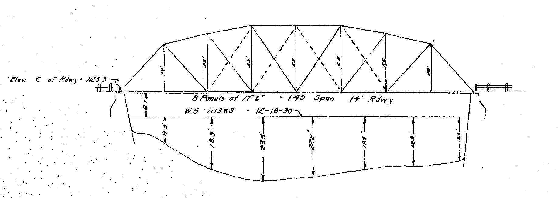
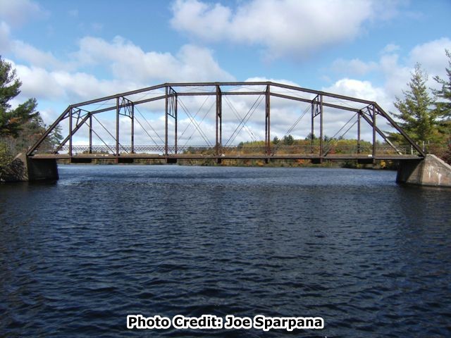
This abandoned bridge crosses the Menominee River, which at this point forms the border between Wisconsin and Michigan. An earthen causeway leads up to the bridge, with a longer causeway on the Wisconsin side. This bridge is a single span eight panel pin-connected Camelback through truss. A Camelback truss is a Parker truss that has a top chord / end post of exactly five slopes. The bridge is 140 feet long and has an 18.7 foot roadway. The truss is configured as follows: top chord and end post: back-to-back channels with cover plate and v-lacing; bottom chord: pairs of up-set eyebars; vertical members: back-to-back channels with v-lacing on each side; diagonal members: pairs of up-set eyebars; portal bracing: traditional A-frame design; sway bracing: unusual three panel Howe truss design composed of angles; railing: traditional hub-guard railing composed of two angles with one row of lattice; floorbeams: rolled American Standard Beams (i-beams); deck stringers: rolled American Standard Beams (i-beams); deck surface: concrete; abutments: concrete.

Whether this bridge is considered to be a Michigan bridge or a Wisconsin Bridge, this historic truss bridge is clearly one of the most historically significant bridges in the region, and has state level significance in both Wisconsin and Michigan. In Michigan, the bridge's high level of significance is defined quite clearly: it is the only known example of a highway pin-connected Camelback truss bridge in the state. The significance is similar in Wisconsin, where the bridge is one of only two known examples of a highway Camelback truss bridge in the state. Further technological significance for the bridge arises from its excellent historic integrity, with the bridge exhibiting little to no alterations. Also, although the overall truss is traditionally composed, the sway bracing exhibits an unusual three panel Howe truss design. This design appears to have been used with the goal being the economical use of materials, since it may have saved material over a traditional sway bracing with a lattice design. The bridge is also a rare surviving example of a bridge built by the Central States Bridge Company.

Original plans for the bridge survive and indicate that the bridge was built by the Central States Bridge Company of Indianapolis, Indiana. M.W. Torkelson, bridge engineer of Wisconsin performed design work for the bridge. Original plans for the bridge are dated 1909. The bridge apparently served an alignment of what became the US-2 highway, until a new US-2 bridge was built on new alignment in 1934. This new US-2 bridge was associated with a realignment of an entire section of US-2 highway, according to Michigan Highways. The truss bridge would likely have then assumed a role of carrying local traffic only, if that. It is likely this reason why the bridge has such good historic integrity with little alteration.
Very few examples of the Central States Bridge Company remain nationwide, although examples of their work can be found spread out over a number of states. Personal communication with James Stewart, and the 1984 Directory of American Bridge Building Companies 1840-1900 By Victor C. Darnell, and the 1903 A.I.S.A. directory provides some insight into the history of the Central States Bridge Company. The company began in New Castle, Indiana as the New Castle Bridge Company in 1897, relocating to Indianapolis c.1900. In 1903, the company had 5000 gross tons of production capacity making it a somewhat small bridge company. The company changed its name to Central States Bridge Company in 1905 and continued to operate into the 1930s. Known people who were officers or owners of the bridge company included Eugene Runyan, Thomas Campbell, John Campbell, and J. E. Troyer.

Above: Aerial view of bridge, August 27, 2020. Click for enlargement. Photo Credit: Doug Heim, Angelcopter, LLC
All of the elements upon which a metal truss bridge's historic integrity is traditionally judged appear to be original and complete including all truss members and overhead bracing. There does not appear to have been replacement or loss of any truss or bracing members and chords. Further, no welded changes, modern bolts, or other major alterations or additions are apparent. All bracing and truss members and chords appear to be intact and complete. Further, even elements of the bridge that are traditionally given less or no consideration in terms of assessing historic integrity appear to be original and unaltered. The floorbeams appear to be original, as do the lattice hubguard railing (one panel of railing is missing). The stringers and the concrete deck follow the design outlined in the original plans and indeed physically appear as though they may be original, as unusual as that would be. The only change appears to have been the addition of an asphalt wearing surface.
![]()
![]()
![]()

![]()
This bridge is abandoned and closed to all traffic.
Coordinates (Latitude, Longitude):
Search For Additional Bridge Listings:
Bridgehunter.com: View listed bridges within 0.5 miles (0.8 kilometers) of this bridge.
Bridgehunter.com: View listed bridges within 10 miles (16 kilometers) of this bridge.
Additional Maps:
Google Streetview (If Available)
GeoHack (Additional Links and Coordinates)
Apple Maps (Via DuckDuckGo Search)
Apple Maps (Apple devices only)
Android: Open Location In Your Map or GPS App
Flickr Gallery (Find Nearby Photos)
Wikimedia Commons (Find Nearby Photos)
Directions Via Sygic For Android
Directions Via Sygic For iOS and Android Dolphin Browser
USGS National Map (United States Only)
Historical USGS Topo Maps (United States Only)
Historic Aerials (United States Only)
CalTopo Maps (United States Only)

© Copyright 2003-2024, HistoricBridges.org. All Rights Reserved. Disclaimer: HistoricBridges.org is a volunteer group of private citizens. HistoricBridges.org is NOT a government agency, does not represent or work with any governmental agencies, nor is it in any way associated with any government agency or any non-profit organization. While we strive for accuracy in our factual content, HistoricBridges.org offers no guarantee of accuracy. Information is provided "as is" without warranty of any kind, either expressed or implied. Information could include technical inaccuracies or errors of omission. Opinions and commentary are the opinions of the respective HistoricBridges.org member who made them and do not necessarily represent the views of anyone else, including any outside photographers whose images may appear on the page in which the commentary appears. HistoricBridges.org does not bear any responsibility for any consequences resulting from the use of this or any other HistoricBridges.org information. Owners and users of bridges have the responsibility of correctly following all applicable laws, rules, and regulations, regardless of any HistoricBridges.org information.
![]()