

View Information About HSR Ratings
This bridge is a large deck plate girder structure. Although the bridge has a single, uninterrupted deck surface, this bridge is actually two structurally independent bridges right next to each other. The bridge retains original railings, having been rehabilitated by MDOT using their unique preservation technique which adds low-profile crash-resistant railings, while not removing original decorative R4 style railing panels from the bridge.
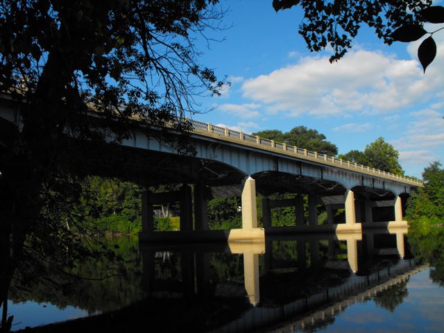
Information and Findings From Michigan Historic Bridge InventoryNarrative Description The five-span US-12 Bridge consists of two identical side-by-side superstructures, one carrying the eastbound lanes and one for the westbound lanes. A narrow gap separates the structures. East side has two variable-depth deck plate girders with four steel I-beam floor beams per span. The center 101-foot span is flanked by 100-foot spans; the outer spans are 89.5 feet. Four steel I-beam stringers extend between each pair of floor beams. A series of back-to-back angles serves as bridging between the girders, below the floor beams. Three-and-one-half-foot-wide sections of concrete, supported by brackets made of angle braces and plates, are cantilevered beyond the girders. These projecting sections support the curbs and sidewalks on the outside, and the median in the middle, of the deck. Standard-design metal railings and posts edge the outside of the sidewalks. The bridge is supported by H-shaped concrete piers and by concrete stub abutments with U-shaped concrete wing walls. Bridge plates are affixed at the northeast and southwest corners. The bridge was built in 1954 as part of the relocation of M-60, now US-12, south of Niles. The contractor for the $634,107.84 federal-aid project, L.W. Lamb of Holland and Jackson, had been in business since at least the 1930s, and had erected a number of bridges in Michigan. One of the 65 highway river crossings planned by the state highway department during the 1953-54 biennium, the US-12 Bridge followed the department's practice of including divider strips between opposing lanes of traffic on dual-lane highways, and using "separate structures carrying each roadway...where roadways are widely separated." This project also reflected the department's push to construct urban by-passes on the seven routes in Michigan included in the 37,681-mile system authorized by the U.S. Public Works Administration in 1947. Work began at Jackson and Flint during 1951-1952. The Niles by-pass joined similar projects in Ann Arbor, Muskegon, Holland, Kalamazoo, Michigan (I-94) and South Bend, Indiana (I-80 and I-90). |
![]()
![]()
![]()
Coordinates (Latitude, Longitude):
Search For Additional Bridge Listings:
Bridgehunter.com: View listed bridges within 0.5 miles (0.8 kilometers) of this bridge.
Bridgehunter.com: View listed bridges within 10 miles (16 kilometers) of this bridge.
Additional Maps:
Google Streetview (If Available)
GeoHack (Additional Links and Coordinates)
Apple Maps (Via DuckDuckGo Search)
Apple Maps (Apple devices only)
Android: Open Location In Your Map or GPS App
Flickr Gallery (Find Nearby Photos)
Wikimedia Commons (Find Nearby Photos)
Directions Via Sygic For Android
Directions Via Sygic For iOS and Android Dolphin Browser
USGS National Map (United States Only)
Historical USGS Topo Maps (United States Only)
Historic Aerials (United States Only)
CalTopo Maps (United States Only)

© Copyright 2003-2024, HistoricBridges.org. All Rights Reserved. Disclaimer: HistoricBridges.org is a volunteer group of private citizens. HistoricBridges.org is NOT a government agency, does not represent or work with any governmental agencies, nor is it in any way associated with any government agency or any non-profit organization. While we strive for accuracy in our factual content, HistoricBridges.org offers no guarantee of accuracy. Information is provided "as is" without warranty of any kind, either expressed or implied. Information could include technical inaccuracies or errors of omission. Opinions and commentary are the opinions of the respective HistoricBridges.org member who made them and do not necessarily represent the views of anyone else, including any outside photographers whose images may appear on the page in which the commentary appears. HistoricBridges.org does not bear any responsibility for any consequences resulting from the use of this or any other HistoricBridges.org information. Owners and users of bridges have the responsibility of correctly following all applicable laws, rules, and regulations, regardless of any HistoricBridges.org information.
![]()