

View Information About HSR Ratings

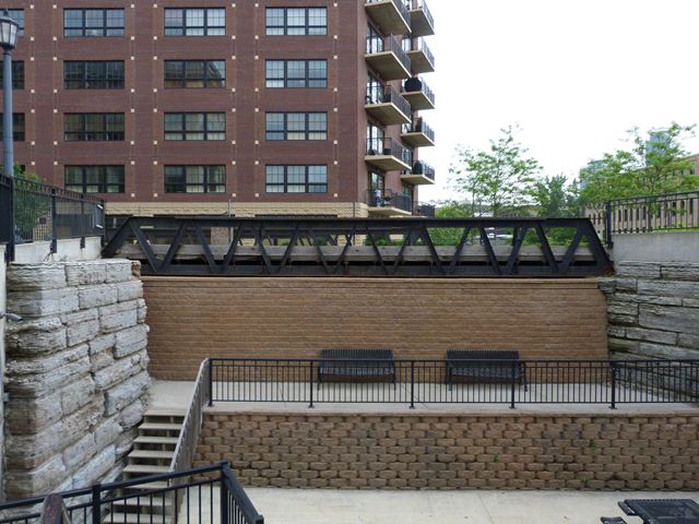
This is an unusual and noteworthy bridge and is part of the St. Anthony Falls Historic District. The bridge is significant as an early rivet-connected truss bridge in Minnesota. The bridge is also noted for its configuration as a Warren truss bridge with no verticals. The bridge has a noteworthy 60 degree skew. The bridge has very shallow trusses with a depth of 5. The accommodate a wide deck, three truss lines were used, with the third line in the middle of the roadway.
This is a historic bridge that has been spared demolition and preserved, despite a radically changing surrounding. The bridge was built to carry 4th Street over a pair of railroad tracks. Old inspection reports for the bridge indicate that the tracks were removed under the bridge in 1985. The bridge was listed as closed to traffic in 1993. At the time, the bridge had a wooden deck.
Fast forward to 2013, and the bridge today has been preserved and serves only non-motorized traffic. The bridge itself does not appear to serve any functional purpose, since the railroad tracks are long gone, and the bridge appears to rest on top of a building. The bridge has not moved, and it continues to sit on its stone abutments, but its surroundings have changed a lot. The surrounding area, once likely an industrial area, today serves residential towers. The bridge remains today as an important historic bridge and an important reminder of this location's past.

![]()
![]()
![]()
Coordinates (Latitude, Longitude):
Search For Additional Bridge Listings:
Bridgehunter.com: View listed bridges within 0.5 miles (0.8 kilometers) of this bridge.
Bridgehunter.com: View listed bridges within 10 miles (16 kilometers) of this bridge.
Additional Maps:
Google Streetview (If Available)
GeoHack (Additional Links and Coordinates)
Apple Maps (Via DuckDuckGo Search)
Apple Maps (Apple devices only)
Android: Open Location In Your Map or GPS App
Flickr Gallery (Find Nearby Photos)
Wikimedia Commons (Find Nearby Photos)
Directions Via Sygic For Android
Directions Via Sygic For iOS and Android Dolphin Browser
USGS National Map (United States Only)
Historical USGS Topo Maps (United States Only)
Historic Aerials (United States Only)
CalTopo Maps (United States Only)

© Copyright 2003-2024, HistoricBridges.org. All Rights Reserved. Disclaimer: HistoricBridges.org is a volunteer group of private citizens. HistoricBridges.org is NOT a government agency, does not represent or work with any governmental agencies, nor is it in any way associated with any government agency or any non-profit organization. While we strive for accuracy in our factual content, HistoricBridges.org offers no guarantee of accuracy. Information is provided "as is" without warranty of any kind, either expressed or implied. Information could include technical inaccuracies or errors of omission. Opinions and commentary are the opinions of the respective HistoricBridges.org member who made them and do not necessarily represent the views of anyone else, including any outside photographers whose images may appear on the page in which the commentary appears. HistoricBridges.org does not bear any responsibility for any consequences resulting from the use of this or any other HistoricBridges.org information. Owners and users of bridges have the responsibility of correctly following all applicable laws, rules, and regulations, regardless of any HistoricBridges.org information.
![]()