

View Information About HSR Ratings

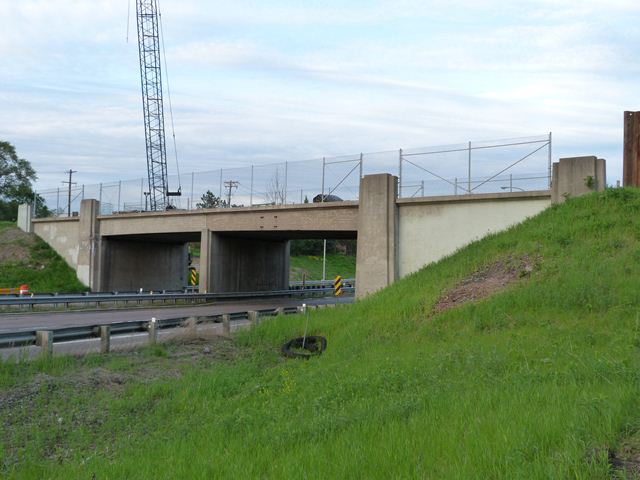
This bridge was originally built to carry a railroad line for the Northern Pacific Railway over MN-36. However, in more recent history the railroad line and this bridge were later converted to serve a rail-trail, with the railroad line being removed. This bridge was not the oldest freeway overpass, but with a 1954 construction date it was fairly old and old enough to have aesthetic details that would not be found on younger bridges. As originally designed, the bridge was a steel stringer bridge with the outermost fascia beam encased in concrete for decorative purposes to make the bridge look like an all-concrete bridge. Decorative pillars were part of the abutment design. Ornamental steel railings were originally present on the bridge, although these had been removed and replaced with cyclone fencing when HistoricBridges.org documented the bridge in 2013, a seemingly minor change but one that greatly hurt the aesthetic qualities of the bridge. When HistoricBridges.org documented this bridge in spring of 2013, a replacement bridge had begun construction. The historic bridge was demolished later in the year. The replacement bridge appears to have been built to provide a longer span, presumably to allow for the widening of MN-36. With the replacement of this bridge with a pedestrian bridge, there is no longer any evidence that a railroad line once crossed at this location.
![]()
![]()
![]()
This historic bridge has been demolished. This map is shown for reference purposes only.
Coordinates (Latitude, Longitude):
Search For Additional Bridge Listings:
Bridgehunter.com: View listed bridges within 0.5 miles (0.8 kilometers) of this bridge.
Bridgehunter.com: View listed bridges within 10 miles (16 kilometers) of this bridge.
Additional Maps:
Google Streetview (If Available)
GeoHack (Additional Links and Coordinates)
Apple Maps (Via DuckDuckGo Search)
Apple Maps (Apple devices only)
Android: Open Location In Your Map or GPS App
Flickr Gallery (Find Nearby Photos)
Wikimedia Commons (Find Nearby Photos)
Directions Via Sygic For Android
Directions Via Sygic For iOS and Android Dolphin Browser
USGS National Map (United States Only)
Historical USGS Topo Maps (United States Only)
Historic Aerials (United States Only)
CalTopo Maps (United States Only)

© Copyright 2003-2024, HistoricBridges.org. All Rights Reserved. Disclaimer: HistoricBridges.org is a volunteer group of private citizens. HistoricBridges.org is NOT a government agency, does not represent or work with any governmental agencies, nor is it in any way associated with any government agency or any non-profit organization. While we strive for accuracy in our factual content, HistoricBridges.org offers no guarantee of accuracy. Information is provided "as is" without warranty of any kind, either expressed or implied. Information could include technical inaccuracies or errors of omission. Opinions and commentary are the opinions of the respective HistoricBridges.org member who made them and do not necessarily represent the views of anyone else, including any outside photographers whose images may appear on the page in which the commentary appears. HistoricBridges.org does not bear any responsibility for any consequences resulting from the use of this or any other HistoricBridges.org information. Owners and users of bridges have the responsibility of correctly following all applicable laws, rules, and regulations, regardless of any HistoricBridges.org information.
![]()