

View Information About HSR Ratings


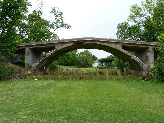
This bridge is an extremely rare example of a Melan arch bridge, which involves using solid steel arch ribs inside the concrete for reinforcement instead of the reinforcing rods (rebar) that later became the dominant reinforcement type. There are actually two Melan arch bridges in Melan park, the other one a short distance west of this one on Lexington Parkway. This foot bridge has been abandoned for many years and has deteriorated. The only interesting thing caused by the deterioration is that it exposed the reinforcing, allowing HistoricBridges.org to photograph this part of the bridge that should be hidden from view. The steel arches are built up and include v-lacing in the lower sections and battens in the upper sections (in the vicinity of the crown), which hold a pair of angles together. In the 1960s, vandals destroyed the beautiful concrete balustrade railing on this bridge. This bridge was previously at risk for demolition, but recently a decision was made to rehabilitate this historic bridge. The city even located the original plans for the railings in a historical article, and will be replicating them on this bridge. The project is ongoing as of 2015. When completed, it appears this will represent an outstanding historic concrete bridge preservation project.


This bridge is tagged with the following special condition(s): Melan
![]()
![]()
![]()
Coordinates (Latitude, Longitude):
Search For Additional Bridge Listings:
Bridgehunter.com: View listed bridges within 0.5 miles (0.8 kilometers) of this bridge.
Bridgehunter.com: View listed bridges within 10 miles (16 kilometers) of this bridge.
Additional Maps:
Google Streetview (If Available)
GeoHack (Additional Links and Coordinates)
Apple Maps (Via DuckDuckGo Search)
Apple Maps (Apple devices only)
Android: Open Location In Your Map or GPS App
Flickr Gallery (Find Nearby Photos)
Wikimedia Commons (Find Nearby Photos)
Directions Via Sygic For Android
Directions Via Sygic For iOS and Android Dolphin Browser
USGS National Map (United States Only)
Historical USGS Topo Maps (United States Only)
Historic Aerials (United States Only)
CalTopo Maps (United States Only)

© Copyright 2003-2024, HistoricBridges.org. All Rights Reserved. Disclaimer: HistoricBridges.org is a volunteer group of private citizens. HistoricBridges.org is NOT a government agency, does not represent or work with any governmental agencies, nor is it in any way associated with any government agency or any non-profit organization. While we strive for accuracy in our factual content, HistoricBridges.org offers no guarantee of accuracy. Information is provided "as is" without warranty of any kind, either expressed or implied. Information could include technical inaccuracies or errors of omission. Opinions and commentary are the opinions of the respective HistoricBridges.org member who made them and do not necessarily represent the views of anyone else, including any outside photographers whose images may appear on the page in which the commentary appears. HistoricBridges.org does not bear any responsibility for any consequences resulting from the use of this or any other HistoricBridges.org information. Owners and users of bridges have the responsibility of correctly following all applicable laws, rules, and regulations, regardless of any HistoricBridges.org information.
![]()