

View Information About HSR Ratings
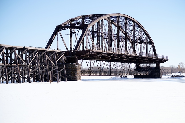
Originally a large swing bridge over the river, today only one of the fixed approach truss spans remain today. The bridge was built in 1897. As originally designed it had a 485 foot swing span (one of the longest swing spans in the country) and was flanked by one 325 foot through truss approach span at each end of the swing span. Only after a few years of operation, in 1906, the bridge was hit by the steamer Troy of the Western Transit Line, at 1am, August 11. The swing span was replaced by a new swing span, which appears to have been nearly identical to the 1897 span, including decorative finials and pedimented portal bracing. The bridge was designed to carry a combination of railroad and highway traffic, with highway traffic using a cantilevered deck. Highway traffic ceased on the bridge i n 1961 when the nearby high level Blatnik Bridge was completed. Photos showing the construction of the Blatnik Bridge appear to show that by this time, one of the fixed through truss approach spans on this bridge had been replaced by a timber trestle structure. The bridge was closed and the swing span left open in 1962. In the 1970s, the swing span was demolished, leaving the other fixed through truss span the only surviving truss span of the bridge. In the 1990s, a unique fishing pier deck was hung from the underside of this bridge, so the span has found new life in this adaptive reuse. Note: Dimensions and structure details given above refer to the bridge structure as seen today, not as originally built. As originally built, the bridge length was 1,920 feet.

Above: Historical photo showing bridge with all three truss spans.

Above: Historical photo showing swing span collapse.

Above: Historical photo showing swing span collapse.

Above: Photo showing the bridge when the Blatnik Bridge was being built. Note how one of the fixed Parker truss spans has been replaced.
![]()
![]()
![]()
Coordinates (Latitude, Longitude):
Search For Additional Bridge Listings:
Bridgehunter.com: View listed bridges within 0.5 miles (0.8 kilometers) of this bridge.
Bridgehunter.com: View listed bridges within 10 miles (16 kilometers) of this bridge.
Additional Maps:
Google Streetview (If Available)
GeoHack (Additional Links and Coordinates)
Apple Maps (Via DuckDuckGo Search)
Apple Maps (Apple devices only)
Android: Open Location In Your Map or GPS App
Flickr Gallery (Find Nearby Photos)
Wikimedia Commons (Find Nearby Photos)
Directions Via Sygic For Android
Directions Via Sygic For iOS and Android Dolphin Browser
USGS National Map (United States Only)
Historical USGS Topo Maps (United States Only)
Historic Aerials (United States Only)
CalTopo Maps (United States Only)

© Copyright 2003-2024, HistoricBridges.org. All Rights Reserved. Disclaimer: HistoricBridges.org is a volunteer group of private citizens. HistoricBridges.org is NOT a government agency, does not represent or work with any governmental agencies, nor is it in any way associated with any government agency or any non-profit organization. While we strive for accuracy in our factual content, HistoricBridges.org offers no guarantee of accuracy. Information is provided "as is" without warranty of any kind, either expressed or implied. Information could include technical inaccuracies or errors of omission. Opinions and commentary are the opinions of the respective HistoricBridges.org member who made them and do not necessarily represent the views of anyone else, including any outside photographers whose images may appear on the page in which the commentary appears. HistoricBridges.org does not bear any responsibility for any consequences resulting from the use of this or any other HistoricBridges.org information. Owners and users of bridges have the responsibility of correctly following all applicable laws, rules, and regulations, regardless of any HistoricBridges.org information.
![]()