

View Information About HSR Ratings
Key facts
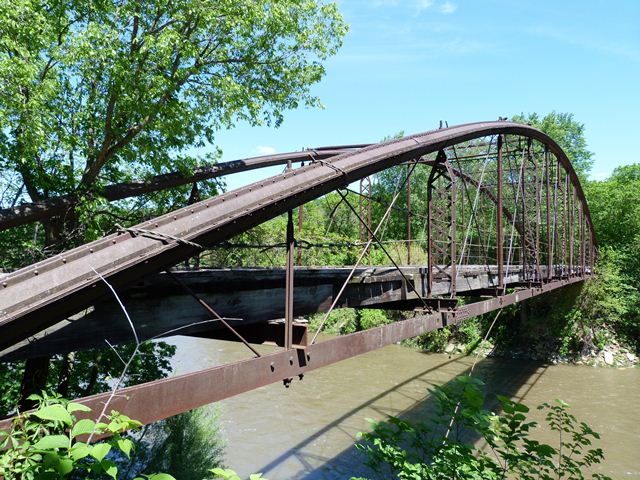
• Listed on National Register of Historic Places
• Initial Crossing – Mankato/South Bend Ivywood Lane (Township Road 190) over Le Sueur River
• Type – only bowstring arch in Minnesota; made of wrought iron
• Year built - 1873 (one of Minnesota’s oldest bridges) for a cost of $8,652
• Length - 189 ft.; extant longest bowstring span in the United States
• Use – initially used for horse and buggy traffic; closed to pedestrians and vehicles early 1990s
• Removed the bridge from the failed limestone block abutments, carefully disassembled, catalogued, hauled and placed bridge components in storage containers.
• After removal the structure was carefully marked and disassembled into large pieces for future refurbishing and re-assembly
The bridge has been removed, carefully dismantled, loaded into sealed containers. New owners will be required to provide a 20-percent match toward the rehabilitation and relist the Kern Bridge on the National Register of Historic places following completion of the rehabilitation effort. Federal funds are available to cover 80 percent with a 20 percent state or local match. Preliminary estimates of the total cost are around $1.5 million. All FHWA/MnDOT rules and requirements must be followed.
Requirements: Must rehabilitate to historic standards (Secretary of the Interior’s Standards for the Treatment of Historic Projects). All FHWA/MnDOT rules and requirements must be followed.
Qualifications: Cities, counties and state agencies. Cities of less than 5,000 population must have county sponsor. Similar to ATP Transportation Alternatives, letter of intent followed by a formal application needed.
Letters of interest due by August 31, 2020.
For more information:
Download News Release and Information Packet
Visit Official Listing Webpage
This bridge is the longest known surviving cast and wrought iron bowstring truss span in the United States and is the second longest in North America, with only the Blackfriars Street Bridge in Ontario being longer. Unlike the Blackfriars Street Bridge however, this bridge enjoys a nearly complete lack of alteration, which is a remarkable achievement for a bridge from the 1870s. Its age, design, lack of alteration, and span length all combine to make this one of the most important historic bridges in the United States. The bridge is currently abandoned and its future is uncertain. It is paramount that this bridge be given the absolute highest preservation priority. The bridge could, if desired, be relocated and reused at a new location. Although maintaining a bridge in its original location is desirable, this bridge's technological significance would not be diminished in a new location. To maintain the bridge's excellent historic integrity, it is important that any preservation work done on the bridge follow the latest techniques of restoration, focused on maintaining original bridge material, employing historical construction methods like riveting, and replicating exactly any parts that must be replaced.
This bridge is tagged with the following special condition(s): Keystone Columns
![]()
![]()
![]()
Coordinates (Latitude, Longitude):
Search For Additional Bridge Listings:
Bridgehunter.com: View listed bridges within 0.5 miles (0.8 kilometers) of this bridge.
Bridgehunter.com: View listed bridges within 10 miles (16 kilometers) of this bridge.
Additional Maps:
Google Streetview (If Available)
GeoHack (Additional Links and Coordinates)
Apple Maps (Via DuckDuckGo Search)
Apple Maps (Apple devices only)
Android: Open Location In Your Map or GPS App
Flickr Gallery (Find Nearby Photos)
Wikimedia Commons (Find Nearby Photos)
Directions Via Sygic For Android
Directions Via Sygic For iOS and Android Dolphin Browser
USGS National Map (United States Only)
Historical USGS Topo Maps (United States Only)
Historic Aerials (United States Only)
CalTopo Maps (United States Only)

© Copyright 2003-2024, HistoricBridges.org. All Rights Reserved. Disclaimer: HistoricBridges.org is a volunteer group of private citizens. HistoricBridges.org is NOT a government agency, does not represent or work with any governmental agencies, nor is it in any way associated with any government agency or any non-profit organization. While we strive for accuracy in our factual content, HistoricBridges.org offers no guarantee of accuracy. Information is provided "as is" without warranty of any kind, either expressed or implied. Information could include technical inaccuracies or errors of omission. Opinions and commentary are the opinions of the respective HistoricBridges.org member who made them and do not necessarily represent the views of anyone else, including any outside photographers whose images may appear on the page in which the commentary appears. HistoricBridges.org does not bear any responsibility for any consequences resulting from the use of this or any other HistoricBridges.org information. Owners and users of bridges have the responsibility of correctly following all applicable laws, rules, and regulations, regardless of any HistoricBridges.org information.
![]()