

View Information About HSR Ratings

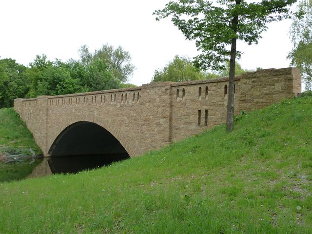
This bridge has a long and unusual history of alteration. It was originally built in 1910 as an open spandrel concrete arch bridge with concrete balustrade railings. Famous engineer C.A.P. Turner designed the bridge. In 1934, the bridge was reportedly deteriorating to some extent and a major reconstruction was undertaken. As part of this project, the bridge was converted to a closed spandrel arch bridge, with a limestone facing added to the bridge. Original balustrade railings were replaced with stone parapets with small openings. An open spandrel concrete arch bridge was transformed into a bridge that looked like a stone arch bridge. In 2011, another massive alteration took place, again a result of deterioration to the bridge. Nearly all of the original bridge material including both concrete and stone was either removed and replaced, or was covered up by new concrete. The intent of the project was the maintain the appearance of the bridge following the 1934 project. The only original 1934 stone reused on the bridge was the railing caps! The railings were made slightly taller, and special stones stepped inside the openings on the railing were used to keep the original appearance of the railing, but close up the holes to meet whatever silly railing codes are in place these days. The arch barrel is lined with precast concrete arches.
This bridge could hardly be called a preserved historic bridge with so much original bridge material lost. Yet, the bridge does look a lot nicer than a hideous prefabricated ConSpan bridge, which was apparently what the city had also considered. The bridge does offer some interpretive value into what the 1934 bridge looked like.

![]()
![]()
![]()
Coordinates (Latitude, Longitude):
Search For Additional Bridge Listings:
Bridgehunter.com: View listed bridges within 0.5 miles (0.8 kilometers) of this bridge.
Bridgehunter.com: View listed bridges within 10 miles (16 kilometers) of this bridge.
Additional Maps:
Google Streetview (If Available)
GeoHack (Additional Links and Coordinates)
Apple Maps (Via DuckDuckGo Search)
Apple Maps (Apple devices only)
Android: Open Location In Your Map or GPS App
Flickr Gallery (Find Nearby Photos)
Wikimedia Commons (Find Nearby Photos)
Directions Via Sygic For Android
Directions Via Sygic For iOS and Android Dolphin Browser
USGS National Map (United States Only)
Historical USGS Topo Maps (United States Only)
Historic Aerials (United States Only)
CalTopo Maps (United States Only)

© Copyright 2003-2024, HistoricBridges.org. All Rights Reserved. Disclaimer: HistoricBridges.org is a volunteer group of private citizens. HistoricBridges.org is NOT a government agency, does not represent or work with any governmental agencies, nor is it in any way associated with any government agency or any non-profit organization. While we strive for accuracy in our factual content, HistoricBridges.org offers no guarantee of accuracy. Information is provided "as is" without warranty of any kind, either expressed or implied. Information could include technical inaccuracies or errors of omission. Opinions and commentary are the opinions of the respective HistoricBridges.org member who made them and do not necessarily represent the views of anyone else, including any outside photographers whose images may appear on the page in which the commentary appears. HistoricBridges.org does not bear any responsibility for any consequences resulting from the use of this or any other HistoricBridges.org information. Owners and users of bridges have the responsibility of correctly following all applicable laws, rules, and regulations, regardless of any HistoricBridges.org information.
![]()