

View Information About HSR Ratings

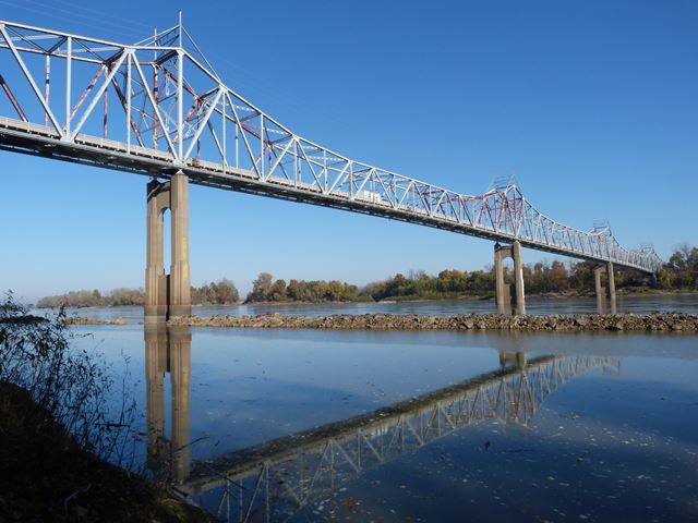
Missouri once had numerous large historic bridges, especially here on the Missouri River. Many of these bridges have been demolished and replaced in recent years. The Missouri River has been hit particularly hard. Therefore, this bridge is today one of the few remaining historic highway bridges on the Missouri River in the state. The bridge is a beautiful and substantial example of a cantilever truss. It is noteworthy on these facts alone, but additional significance is derived from its unusual design, because it is a cantilever structure with five cantilever spans. Most cantilever truss systems have a three span design, with anchor arm spans at each end and in the middle a span composed of cantilever arms and a suspended span. In this bridge, because of the additional spans, the design is more complex. Starting from either end of the bridge, the main spans are configured as follows. First, a 415 foot anchor arm span, then a 475 foot span composed of cantilever arms and a suspended span, then a 475 foot span that does the function of two anchor arms, then a 475 foot span composed of cantilever arms and a suspended span, then a 415 foot anchor arm span. In addition, each end of the bridge has a 50 foot beam span and a 100 foot simple deck truss span. The deck truss span has members that are largely composed of angle, and so the span looks a lot more lightweight in design compared to the main spans, which are traditionally composed of riveted built up beams with typical box-style design including v-lacing, lattice, and battens.
The bridge has a very attractive appearance, with the five span design giving the bridge a distinctive iconic appearance.
The historic integrity of the bridge is good. The only major alteration is that the sway bracing and portal bracing appears to have been cut and rebuilt at the bottom to raise the vertical clearance. This sort of alteration is extremely common among Missouri truss bridges.
Stupp Brothers Bridge and Iron Company opf St. Louis, Missouri and Missouri Valley Bridge and Iron Company of Leavenworth, Kansas were contractors for the bridge. The prolific firm of Sverdrop and Parcel of St. Louis, Missouri was the engineer for the bridge. This firm designed many of the large river bridges that are/were in Missouri.
According to MoDOT, "The preferred alternative to the existing bridge is to construct a new bridge just upstream or west of the existing structure. The new bridge will provide two 12-foot lanes with 10-foot shoulders and an ten-foot protected bike/pedestrian path with a connection to the KATY Trail in Warren County." Following completion of the replacement bridge, the historic bridge will be demolished. This is absolutely and utterly ridiculous and unnecessary. Consider two facts. First, it is important to provide a safe walkway for pedestrians using the KATY Trail. Second, the historic bridge is not in the way of its replacement and therefore does not need to be demolished. Therefore, the solution that should have been chosen is obvious. The 10 foot walkway on the new bridge should be omitted, and the existing historic bridge should be converted for pedestrian use. Consider the popularity and success of the Chain of Rocks Bridge as evidence that this is a viable and useful alternative. As a pedestrian, wouldn't you rather enjoy a walk on a beautiful historic bridge that is completely separated from vehicular traffic, instead of walking on a sidewalk of a modern bridge right next to the roar of heavy traffic? Preservation of the existing historic bridge for pedestrians is feasible. The bridge is really not in bad condition. Very little section loss or pack rust was found on the bridge, and any that is present has been halted by the application of the current paint system which remains in fair to good condition. The concrete piers also appear to be in good condition with no major spalling noted. The bridge is currently capable of carrying a substantial amount of vehicular traffic, and is certainly thus strong enough to bear the light load of pedestrian traffic.
The demolition of this historic bridge will leave Washington with only a replacement bridge, which will be a mundane steel beam bridge that will look like little more than a slab of concrete. The sort of thing that anyone can enjoy on the nearest freeway. Gone will be the unique iconic geometry of the historic bridge that is a symbol for Washington.
Information and Findings From Missouri's Historic Bridge InventoryBridge Features superstructure: steel, rigid-connected, cantilever Warren through truss substructure: concrete abutments and piers with Modeme detailing floor/ decking: concrete deck over steel stringers other features: upper chord and inclined end post: 2 built-up channels with cover plate and lacing; lower chord: 2 built-up channels with batten plates; vertical: 2 angles with lacing; diagonal: 2 channels with lacing or batten plates; lateral bracing: 2 angles with lacing; floor beam: I-beam, field-bolted to vertical; guardrail: 2 steel channels Discussion of Bridge Local citizens and elected officials had been lobbying off-and-on for years for a highway bridge over the Missouri River at Washington. In 1930 the Washington Bridge Committee was formed, and three years later Congress authorized the bridge's construction. Sverdrup and Parcel of St. Louis were hired to engineer the structure, which was to be funded through a combination of federal aid grants, state highway department monies and locally raised loan proceeds. Construction bids let in the spring of 1934 elicited proposals from eleven firms; that summer contracts were awarded to the Missouri Valley Bridge and Iron Company for the substructure and Stupp Brothers Bridge and Iron Company for the superstructure. Work got underway in October 1934, and by late November a hundred workers were employed setting the structure's foundations. Construction of the impressive bridge was carried out over the course of the next eighteen months. The bridge was opened to traffic on April 8, 1936; on May 28th a formal dedication ceremony was held. Attended by a host of regionally important dignitaries, the event featured bridge designer L.J. Sverdrup as the guest of honor. The bridge operated as a toll crossing until the fall of 1951, when its indebtedness was finally retired. During the 1930s and 1940s, the standard toll charge was 45 cents for one-way, or 75 cents for a round-trip crossing. The Washington Bridge today appears largely as originally built, having only been subjected to minor, maintenance related repairs. Fourteen vehicular steel truss bridges over the Missouri River are included in Missouri's statewide historic bridge inventory. As a group, these bridges comprise some of the state's longest examples of truss bridge construction. Undertaken during the depth of the Great Depression, the Washington Bridge was one of a series of great river bridges built in Missouri during the 1920s and 1930s. It has formed a regionally important crossing of the Missouri River: the only span between Hermann and St. Charles. Featuring a cantilevered design, the Washington Bridge ranks among Missouri's most monumental examples of steel truss construction. With a span length of 475 feet and an overall length of 2562 feet, the multiple-span structure clearly ranks as a superlative example of its type. Its distinctive curved profile distinguished it among several great river bridges undertaken in the state by prominent St. Louis civil engineers Sverdrup and Parcel. Similarly configured structures undertaken by Sverdrup and Parcel include the Mark Twain Bridge in Hannibal, the Hermann Bridge and the Miami Bridge. As an important river crossing and a well-preserved example of large-scale bridge construction, the Washington Bridge is one of Missouri's more noteworthy highway trusses. Bridge Considered Historic By Survey: Yes |
![]()

![]()

![]()
![]()
![]()

![]()
This historic bridge has been demolished. This map is shown for reference purposes only.
Coordinates (Latitude, Longitude):
Search For Additional Bridge Listings:
Bridgehunter.com: View listed bridges within 0.5 miles (0.8 kilometers) of this bridge.
Bridgehunter.com: View listed bridges within 10 miles (16 kilometers) of this bridge.
Additional Maps:
Google Streetview (If Available)
GeoHack (Additional Links and Coordinates)
Apple Maps (Via DuckDuckGo Search)
Apple Maps (Apple devices only)
Android: Open Location In Your Map or GPS App
Flickr Gallery (Find Nearby Photos)
Wikimedia Commons (Find Nearby Photos)
Directions Via Sygic For Android
Directions Via Sygic For iOS and Android Dolphin Browser
USGS National Map (United States Only)
Historical USGS Topo Maps (United States Only)
Historic Aerials (United States Only)
CalTopo Maps (United States Only)

© Copyright 2003-2024, HistoricBridges.org. All Rights Reserved. Disclaimer: HistoricBridges.org is a volunteer group of private citizens. HistoricBridges.org is NOT a government agency, does not represent or work with any governmental agencies, nor is it in any way associated with any government agency or any non-profit organization. While we strive for accuracy in our factual content, HistoricBridges.org offers no guarantee of accuracy. Information is provided "as is" without warranty of any kind, either expressed or implied. Information could include technical inaccuracies or errors of omission. Opinions and commentary are the opinions of the respective HistoricBridges.org member who made them and do not necessarily represent the views of anyone else, including any outside photographers whose images may appear on the page in which the commentary appears. HistoricBridges.org does not bear any responsibility for any consequences resulting from the use of this or any other HistoricBridges.org information. Owners and users of bridges have the responsibility of correctly following all applicable laws, rules, and regulations, regardless of any HistoricBridges.org information.
![]()