

View Information About HSR Ratings
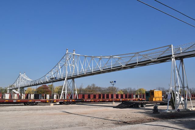
This bridge is an extremely rare example of a cantilever truss footbridge. Because cantilever truss bridges were usually used for long-span crossings over large navigable rivers, they typically were not used for pedestrian-only crossings, which typically are not found on these types of crossings. However in this case, the long-span capability of the cantilever truss enables this footbridge to pass over a railroad yard without the need for many piers or bents which would obstruct the railroad. Aside from its rarity as a cantilever truss footbridge, this is a particularly old surviving cantilever truss of any type in the United States. Most date to after 1920. Lastly, this 1902 bridge, having been built by the American Bridge Company, is an early surviving bridge built under the American Bridge name, as this company had only formed a couple years earlier.
The bridge has a 175 foot main span (with the center four panels being the suspended span), with 100 foot anchor arm spans at each end, for a total cantilever truss length of 375 feet. A rare Queenpost pony truss approach span at the south end (which may not be original), and some stringer spans and stairways add to the overall length of the bridge, with an approximate total of 562 feet including stairways. The cantilever truss is unaltered and retains excellent historic integrity. The approach and stairways however have been altered from the design shown in original drawings, however the reconfigured approaches appear to have been built by simply salvaging and reusing the original approach structural steel and railing.
This bridge includes ornamental finials on the towers (main posts), and retains original lattice railing. It is an outstanding bridge and in 2002 it was rehabilitated. Interpretive signage is placed near the bridge. Nearby "Historic C-Street City Market" logos include the bridge truss in the logo. By all appearances this bridge would seem like it was preserved and appreciated. Nothing could be further from the truth, at least in city government, because the city is now planning to demolish and replace this unique bridge! This is ridiculous. The bridge was closed and fenced off a while ago after bridge inspectors found some pack rust and section loss. Actually, to be accurate, the engineering firm called the pack rust "crevice corrosion" although this term is not industry standard, and its not clear who came up with that term. Rather than propose repairs of the pack rust, and other simple repairs to maintain the bridge as-is for the long term, the city's engineering firm instead is now claiming the bridge must have a 90PSF load rating per AASHTO guidelines (please note that AASHTO guidelines are "Guidelines" and not laws or standards). This bridge does NOT need a 90PSF rating. Only extremely busy bridges such as foot bridges overlooking famous European castles, the Brooklyn Bridge in New York City, and similar bridges ever achieve the density of people required to produce 90PSF. Most people would call the police if a strange stood close enough to them to achieve a density of 90PSF. A group of concerned citizens hired another engineering firm with experience restoring historic bridges, and they proposed a much more reasonable rehab that cost less, would have lesser long-term maintenance costs, and would provide a safe load capacity for the actual levels of usage of this bridge. It remains to be seen whether the city will come to its senses and choose this rehabilitation option and retain this beautiful and iconic city landmark.
An original plan sheet from the bridge is shown below.

![]()
![]()
![]()
Coordinates (Latitude, Longitude):
Search For Additional Bridge Listings:
Bridgehunter.com: View listed bridges within 0.5 miles (0.8 kilometers) of this bridge.
Bridgehunter.com: View listed bridges within 10 miles (16 kilometers) of this bridge.
Additional Maps:
Google Streetview (If Available)
GeoHack (Additional Links and Coordinates)
Apple Maps (Via DuckDuckGo Search)
Apple Maps (Apple devices only)
Android: Open Location In Your Map or GPS App
Flickr Gallery (Find Nearby Photos)
Wikimedia Commons (Find Nearby Photos)
Directions Via Sygic For Android
Directions Via Sygic For iOS and Android Dolphin Browser
USGS National Map (United States Only)
Historical USGS Topo Maps (United States Only)
Historic Aerials (United States Only)
CalTopo Maps (United States Only)

© Copyright 2003-2024, HistoricBridges.org. All Rights Reserved. Disclaimer: HistoricBridges.org is a volunteer group of private citizens. HistoricBridges.org is NOT a government agency, does not represent or work with any governmental agencies, nor is it in any way associated with any government agency or any non-profit organization. While we strive for accuracy in our factual content, HistoricBridges.org offers no guarantee of accuracy. Information is provided "as is" without warranty of any kind, either expressed or implied. Information could include technical inaccuracies or errors of omission. Opinions and commentary are the opinions of the respective HistoricBridges.org member who made them and do not necessarily represent the views of anyone else, including any outside photographers whose images may appear on the page in which the commentary appears. HistoricBridges.org does not bear any responsibility for any consequences resulting from the use of this or any other HistoricBridges.org information. Owners and users of bridges have the responsibility of correctly following all applicable laws, rules, and regulations, regardless of any HistoricBridges.org information.
![]()