

View Information About HSR Ratings

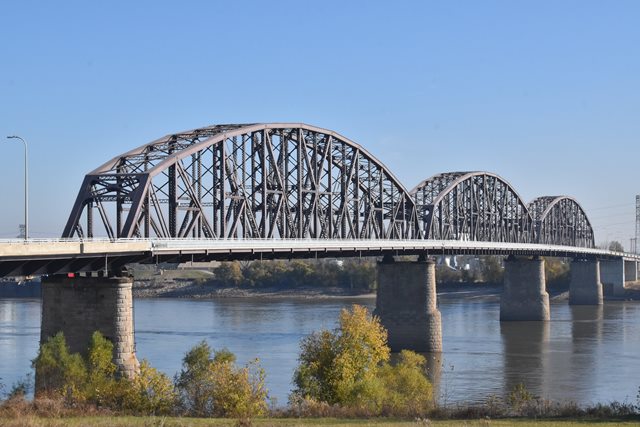
This bridge is a massive through truss. It was designed by famous engineer Ralph Modjeski and is among the earlier of his surviving bridges. The bridge was originally designed to handle railroad traffic, but today only serves vehicular traffic plus a bicycle path. Not part of the original design, there are extra decks cantilevered outside of the truss lines on each side. Although both appear capable of handling a single lane of highway traffic, the south outer deck is now used for the bicycle path, while the other side is closed but appears to be intended for use for detours when the main two lanes between the truss lines are closed for repair. The approach spans for this bridge are all two lanes only, with the cantilevered lanes on the truss ending after the truss spans.
The original approach viaduct for this bridge has been demolished and replaced, with the exception of a section of railroad viaduct which was converted for use on the bike path. The original approach included large deck truss spans that were replaced with steel stringer spans. Historical photos below show the original design and layout of the bridge.


![]()
![]()
![]()
Coordinates (Latitude, Longitude):
Search For Additional Bridge Listings:
Bridgehunter.com: View listed bridges within 0.5 miles (0.8 kilometers) of this bridge.
Bridgehunter.com: View listed bridges within 10 miles (16 kilometers) of this bridge.
Additional Maps:
Google Streetview (If Available)
GeoHack (Additional Links and Coordinates)
Apple Maps (Via DuckDuckGo Search)
Apple Maps (Apple devices only)
Android: Open Location In Your Map or GPS App
Flickr Gallery (Find Nearby Photos)
Wikimedia Commons (Find Nearby Photos)
Directions Via Sygic For Android
Directions Via Sygic For iOS and Android Dolphin Browser
USGS National Map (United States Only)
Historical USGS Topo Maps (United States Only)
Historic Aerials (United States Only)
CalTopo Maps (United States Only)

© Copyright 2003-2024, HistoricBridges.org. All Rights Reserved. Disclaimer: HistoricBridges.org is a volunteer group of private citizens. HistoricBridges.org is NOT a government agency, does not represent or work with any governmental agencies, nor is it in any way associated with any government agency or any non-profit organization. While we strive for accuracy in our factual content, HistoricBridges.org offers no guarantee of accuracy. Information is provided "as is" without warranty of any kind, either expressed or implied. Information could include technical inaccuracies or errors of omission. Opinions and commentary are the opinions of the respective HistoricBridges.org member who made them and do not necessarily represent the views of anyone else, including any outside photographers whose images may appear on the page in which the commentary appears. HistoricBridges.org does not bear any responsibility for any consequences resulting from the use of this or any other HistoricBridges.org information. Owners and users of bridges have the responsibility of correctly following all applicable laws, rules, and regulations, regardless of any HistoricBridges.org information.
![]()