

View Information About HSR Ratings

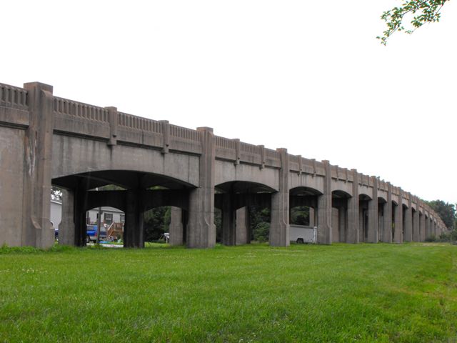
The New Franklin Viaduct, at well over 1000 feet in length, is one of the largest and most impressive concrete bridges in the state of Missouri. Featuring near-perfect historic integrity, decent structural condition, and extensive architectural treatment and design, this massive bridge gracefully rises up above the surrounding landscape, carrying the main road into New Franklin over a former railroad which is now the well-known Katy trail, a noteworthy rails to trails accomplishment in the area.
The New Franklin Viaduct is considered eligible for the National Register of Historic Places.
The bridge is technologically significant because of its design. As an extremely large example of a concrete deck girder, it is a noteworthy engineering achievement and is also a good representative example of a bridge type built during the 1920s and 1930s, although most other examples were smaller bridges. With remarkable historic integrity, the bridge represents the structure type very well.
The bridge is historically significant because of its association with Depression-related public works relief programs. The Historic Bridge Inventory entry at the end of this page discusses this in detail. The New Franklin Viaduct is also significant for being a remnant of a bridge crossing a noteworthy abandoned railroad line (now remade as the Katy Trail), and as such the bridge helps to interpret and understand the history of area railroad lines and the role they played in communities.
The bridge is aesthetically significant as a remarkably beautiful concrete bridge. Its sweeping overall arched shape is complimented by the individual arched girders that form each span. Arched concete piers further compliment and continue the design of arch shapes on the bridge. Decorative concrete balustrade railings top off the appearance of the bridge. The piers are designed to appear to extend above the deck to form large concrete railing posts. The railing posts that are not at pier points are smaller but follow the same appearance. Beautifully crafted stairs are located toward the center of the bridge which were included in the original bridge design to allow pedestrians to cross the railroad tracks when a train was present without having to walk the long distance to the vehicular entrance to the bridge. As such, a sidewalk is only present on the bridge between these stairways, a unique design characteristic.
Finally, the bridge is significant because the local New Franklin community appreciates this bridge. Many residents spoke out against demolition, although MoDOT ignored them. They even have interpretive signage discussing the bridge in the town square.
Given the four areas of significance described below this beautiful historic landmark and New Franklin gateway is a bridge that is extremely important and is more than deserving of preservation. In addition, it is in fact in relatively good condition and could easily be rehabilitated.
Even if you do not care about historic bridges, it is worth supporting the preservation of the New Franklin Viaduct for safety reasons, since the viaduct separates MO-5 traffic from the Katy Trail below. MoDOT claims that the removal of this grade separation will not pose a safety issue for users of the Katy trail. However this statement is absolutely false. In the current configuration it is 100% impossible for a Katy trail user to get hit by MO-5 traffic unless the cars crash through the railings and come flying down from the bridge and land on the trail. In contrast, with the proposed demolition, it will become possible for pedestrian-vehicular collisions at the Katy trail crossing. MoDOT claims the historic bridge is functionally obsolete because of they claim it has a narrow deck (although 24 feet really is not narrow) and they claim the bridge has a short distance with which oncoming traffic may be seen. However, with a relatively slow speed limit on the bridge of 30 miles per hour, fatal vehicular crashes from these perceived issues seem fairly unlikely. In contrast, a 30 miles per hour vehicular-pedestrian collision could most certainly be fatal. MoDOT's lack of concern for the safety of non-motorized traffic in New Franklin is very alarming.
Safety issues set aside, in terms of preservation, if MoDOT still does not want to continue to allow vehicular traffic on the bridge, then the bridge should simply be bypassed at ground level and left standing for its large amount of historic and aesthetic value. Since the plan is to demolish the bridge and bring the road to ground level, why not instead leave the bridge standing and pick a side of the bridge to run MO-5 down? There are already roadways on either side of the bridge.
Demolishing this bridge is a waste of taxpayer money. It will only decrease the beauty and function of the Katy Trail, deprive New Franklin of an impressive "Gateway Bridge" and destroy an important historical and engineering landmark.
Missouri Department of Transportation couldn't even resist spreading their propaganda into the documentation of the bridge, which was mitigation for the demolition of this historic bridge. In the proposed text for the interpretive signage/text, a clear bias toward MoDOTs decision to demolish the bridge is discernable, such as where the comment is made that the viaduct was "no longer needed" which is debatable given the functioning rail-trail. Also, MoDOT is actually proud to declare that they have reduced a landmark historic bridge into the rubble base beneath asphalt on a road. The text is at the end of this narrative.
In the interest of fairness, it is worth commenting that a couple sections of the original railing from the bridge were salvaged and placed next to the interpretive signage. While such meager leavings cannot hope to fill the void left by the loss of this bridge, this does represent an improvement over the mitigation that has been seen with bridges in the past. Often, mitigation wrongly focuses on making a replacement bridge look fancy, or mitigation limits itself to recordation (photographs, narrative) of the historic bridge only, without any additional mitigation. Mitigation should, whenever physically possible, include salvage and preservation of some portion of original bridge material. The salvage of the railings does indeed represent this form of mitigation, and as such it deserves to be recognized as doing a fair job of meeting the spirit of Section 106 mitigation, when it is decided to demolish a historic bridge.
Information and Findings From MoDOT's Demolition Mitigation Interpretive TextTheme The New Franklin Viaduct was an engineering work that served its purpose, and when its useful life was over, was repurposed. The Need When the Missouri, Kansas and Texas (MKT) Railroad established a Division in Franklin, a switching yard was located south of New Franklin. This switching yard contained seven sets of tracks plus the through line. Missouri Highway 5 entered New Franklin by crossing this switching yard. There were several fatal accidents in the area before the viaduct was constructed. Construction Funding for the viaduct came in from the 1936 federal highway aid bill, which made reducing grade crossings of railroads a high priority. It was decided to construct the viaduct as a concrete deck girder because that would be the cheapest ways to build the structure. The decision was also made to add an unusual amount of architectural detailing to the structure because of the importance of the crossing and its location between Boonville and Fayette. Carrothers and Crouch of Kansas City was selected to build the structure. They used much local labor, keeping unemployment in the community down while it was being constructed. The official dedication was part of an all-day celebration. After the MKT After the MKT Railroad stopped running in 1986 the switching yard was removed. The through line was replaced by the Katy Trail state park. From that time the future of the viaduct came into question. As early as 1993 there was discussion about removing it, since it was no longer needed. The Parkway The Missouri Department of Transportation decided to remove the viaduct in 2009 and replace it with a parkway. A part of the railing was incorporated into the Katy Trail State Park, retaining this decorative feature. More than half of the remaining structure was recycled into the at-grade parkway, which replaced the viaduct, rather than being removed to a landfill. |
![]()
Information and Findings From Missouri's Historic Bridge InventoryBridge Features Superstructure: multiple span, concrete deck girder
viaduct Discussion of Bridge As part of the effort to create jobs during the Depression, Congress in 1934 passed an act allowing federal monies to be used for road and bridge construction within municipalities. Taking advantage of the new legislation, the Missouri State Highway Commission undertook a number of urban road and bridge projects during the late 1930s. Located on the southern side of New Franklin on State Highway 5, the New Franklin Viaduct was one such construction project. To span the Missouri, Kansas & Texas Railroad, the Missouri State Highway Department engineered a multiple-span concrete girder structure, with slightly arched girders, open balustrade guardrails and pedestrian stairways at both ends. On September 22, 1939, a $167,894.18 contract for the structure's construction was awarded to Carrothers and Crouch. Completed the following year, the New Franklin Viaduct has since carried increasingly heavy traffic loads on the principal highway leading into the city from the south. As an important crossing of the MKT Railroad, the New Franklin Viaduct has formed an integral part of the city's street system. The viaduct is also important as one of the railroad separation projects funded through the New Deal's Hayden-Cartwright Act. Federal relief programs of the 1930s broke with past practice by allowing federal funds to be used for urban, as well as rural highways. Grade separation was a major focus of the highway department during this period, requiring commitment of much staff time. The New Franklin Viaduct is technologically distinguished as a multiple-span and long-span example of a MSHD mainstay structural type - the concrete deck girder. A well-preserved, regionally important example of this common bridge type, the structure is both technologically and historically significant. Bridge Considered Historic By Survey: Yes |
![]()
![]()
![]()
This historic bridge has been demolished. This map is shown for reference purposes only.
Coordinates (Latitude, Longitude):
Search For Additional Bridge Listings:
Bridgehunter.com: View listed bridges within 0.5 miles (0.8 kilometers) of this bridge.
Bridgehunter.com: View listed bridges within 10 miles (16 kilometers) of this bridge.
Additional Maps:
Google Streetview (If Available)
GeoHack (Additional Links and Coordinates)
Apple Maps (Via DuckDuckGo Search)
Apple Maps (Apple devices only)
Android: Open Location In Your Map or GPS App
Flickr Gallery (Find Nearby Photos)
Wikimedia Commons (Find Nearby Photos)
Directions Via Sygic For Android
Directions Via Sygic For iOS and Android Dolphin Browser
USGS National Map (United States Only)
Historical USGS Topo Maps (United States Only)
Historic Aerials (United States Only)
CalTopo Maps (United States Only)

© Copyright 2003-2024, HistoricBridges.org. All Rights Reserved. Disclaimer: HistoricBridges.org is a volunteer group of private citizens. HistoricBridges.org is NOT a government agency, does not represent or work with any governmental agencies, nor is it in any way associated with any government agency or any non-profit organization. While we strive for accuracy in our factual content, HistoricBridges.org offers no guarantee of accuracy. Information is provided "as is" without warranty of any kind, either expressed or implied. Information could include technical inaccuracies or errors of omission. Opinions and commentary are the opinions of the respective HistoricBridges.org member who made them and do not necessarily represent the views of anyone else, including any outside photographers whose images may appear on the page in which the commentary appears. HistoricBridges.org does not bear any responsibility for any consequences resulting from the use of this or any other HistoricBridges.org information. Owners and users of bridges have the responsibility of correctly following all applicable laws, rules, and regulations, regardless of any HistoricBridges.org information.
![]()