

View Information About HSR Ratings
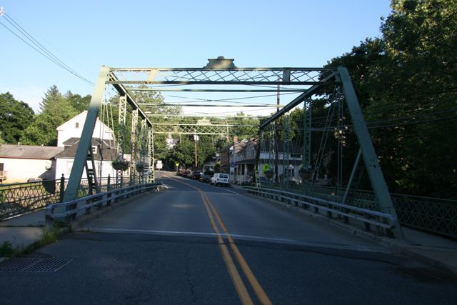
To anyone who has visited more than a few metal truss bridges, this structure looks wrong before you even get out of your car to examine it. A traditional lightweight pin-connected Pratt through truss except that it is way too wide, holding a generous two-lanes when the design of the bridge is clearly intended for a one-lane structure. A quick glance beneath the bridge reveals just what you would expect: modern steel stringers. This bridge had two drastic things done to it. It was widened to two lanes, and then it was placed on a new stringer bridge. The trusses are merely decorative and do not function in any way. The original roadway width was 17.2 Feet (5.2 Meters). Prior to alteration, the bridge was rehabilitated in 1936 and 1993.
In many ways widening the truss is more invasive than placing a truss onto a modern bridge to act as a decoration because when the bridge is widened it changes the proportions of the bridge and it makes the bridge look fake. However this bridge had both done to it.
On the other hand, doing this was better than demolishing the bridge completely. The original material of the truss webs remains for the viewing and inspection of all who cross the bridge. This is far better than what some states do when they decide a historic truss bridge is functionally obsolete.
General historic bridge etiquette is to consider all other alternatives, and accept this sort of a solution (widening the truss, and/or rendering the trusses decorative) when all other alternatives to demolition have been exhausted, such as relocation to a park setting, bypassing the bridge, creating a one-way couplet, etc. Assuming that these alternatives were considered and the opinions of local historic societies etc were considered, than this may have well been the only acceptable solution for this particular bridge.
This bridge is a great teaching tool for anyone working with historic bridges, since it can be used as an illustrative example for an uncommonly seen preservation alternative.
Historically, the bridge is noteworthy as an example of the prolific Toledo Bridge Company, which was originally the Smith Bridge Company, both of Toledo, Ohio. This bridge is noteworthy as an example of their work a considerable distance from their base of operations. The company was prolific and did work nationally, but most surviving examples seem to be in Ohio, Indiana, and Michigan.
Information and Findings From New Jersey's Historic Bridge InventoryDiscussion of Bridge Summary: The pin-connected Pratt thru-truss bridge sits on stone abutments, the southern one with a concrete toe wall. The verticals and top chords are built-up members, while the diagonals and the bottom chords are eyebars. 1936 alterations include weld-connected bars strengthening some of the members. In 1994 the bridge was widened. It is one of four thru truss bridges in the county. The bridge is individually eligible for listing in the National Register of Historic Places under Criterion C. In addition, the bridge is eligible under Criteria A and C as a contributing element of the North Bloomsbury Historic District. Bibliography: Darnell, Victor.
Directory of American Bridge Building Companies, 1840-1900. Washington,
DC: 1984. Physical Description: The skewed 6-panel pin-connected Pratt thru truss bridge is supported on an ashlar substructure. Although it was strengthened in 1936 with additional members welded to the original trusses, the span retains much of its original fabric and configuration, including cantilevered sidewalks with metal lattice-pattern railings. The inclined end posts and top chord are built-up members of channel with cover plate and laced stiffening. The verticals are toe-out channels with lacing on each face, and the diagonals and bottom chord are eye bars, some of which have stamped eyes and some of which have looped forged eyes. Each braced portal brace with lattice infill is topped by a bridge plaque. The floor beams are rolled. A low lattice railing separates the roadway from the sidewalks. Strengthening is limited to the outside panels, which have additional vertical hangers, diagonals, and a sub diagonals. Such modifications to pin-connected thru truss bridges from the late-19th century are not uncommon. Historical and Technological Significance: The pin-connected Pratt thru truss bridge was built in 1892, and it is significant on its own merits as oldest and one of the most complete "high" truss bridges in the county (Criterion C). Although the span has been modified, as early as 1936 when it was strengthened by the addition of welded members, most of the original fabric, including railings at both the sidewalks and the truss lines, remains in place, and the span still functions as a pin-connected bridge. The bridge is also a contributing resource in the North Bloomsbury Historic District. The district is comprised of a late eighteenth/early nineteenth century crossroads village that developed along the New Brunswick turnpike in Hunterdon County. The district includes 14 residences with their associated outbuildings, one small industrial complex, and a bridges, as well as farm fields, pastureland, wood lots, and bottomland of the Musconetcong River. Although this area traditionally supported an agricultural way of life [which continues to the present], historically, a mid-eighteenth century forge was located in the immediate area and the river supported gristmills, distilleries and an early iron industry. The North Bloomsbury Historic District is significant because it represents a small crossroads community that was developed by and is associated with the locally prominent Smith family, who were successful members of the local agricultural community. It is also significant for its well preserved examples of stylish Georgian and Federal period architecture, which represent some of Warren County's finest early nineteenth century architecture. The period of significance for the district is 1780 to 1900. Four pin-connected thru truss bridges survive in Warren County (2102307, 2102015, 2160153, 2100718). Three were built by the county, and one was erected by the Lehigh Valley Railroad to carry a local road over its right-of-way. Because of the scarcity of the once-common bridge type in Warren County, all four of the thru trusses bridges were evaluated as significant because they are rare local examples of a structure type that played an important role in the historical development of the county. The Toledo Bridge Company of Toledo, Ohio fabricated the Church Street bridge. Robert W. Smith of Tippicanoe City, Ohio founded the company in 1867, and in 1869 moved it to Toledo under the name of the Smith Bridge Company specializing in Smith's patented wood and iron bridges. In 1890 Smith sold the company and the new owners changed the name to the Toledo Bridge Company. In 1894 the company had an annual capacity of 6 thousand tons, a respectable but not large figure for the time. In 1901, the company was purchased by the American Bridge Company as part of its multi-company merger. Boundary Description and Justification: The bridge is individually eligible and it is located within a historic district. The district is bounded by the Musconetcong River on the south, and by an historic tree line along agricultural fields to the north. Eastern and western boundaries are somewhat irregular in order to include specific properties. Discussion of Surrounding Area The bridge is located in a potential historic district in the town of Bloomsbury. It carries a main street over the Musconetcong River, the boundary between Warren and Hunterdon Counties. The bridge has two lanes for traffic and two sidewalks. Both sides of the river have 19th century residences and commercial structures that contribute to the district, as does the bridge. Bridge Considered Historic By Survey: Yes |
This bridge is tagged with the following special condition(s): Trusses Converted To Decorative
![]()
![]()
![]()
Coordinates (Latitude, Longitude):
Search For Additional Bridge Listings:
Bridgehunter.com: View listed bridges within 0.5 miles (0.8 kilometers) of this bridge.
Bridgehunter.com: View listed bridges within 10 miles (16 kilometers) of this bridge.
Additional Maps:
Google Streetview (If Available)
GeoHack (Additional Links and Coordinates)
Apple Maps (Via DuckDuckGo Search)
Apple Maps (Apple devices only)
Android: Open Location In Your Map or GPS App
Flickr Gallery (Find Nearby Photos)
Wikimedia Commons (Find Nearby Photos)
Directions Via Sygic For Android
Directions Via Sygic For iOS and Android Dolphin Browser
USGS National Map (United States Only)
Historical USGS Topo Maps (United States Only)
Historic Aerials (United States Only)
CalTopo Maps (United States Only)

© Copyright 2003-2024, HistoricBridges.org. All Rights Reserved. Disclaimer: HistoricBridges.org is a volunteer group of private citizens. HistoricBridges.org is NOT a government agency, does not represent or work with any governmental agencies, nor is it in any way associated with any government agency or any non-profit organization. While we strive for accuracy in our factual content, HistoricBridges.org offers no guarantee of accuracy. Information is provided "as is" without warranty of any kind, either expressed or implied. Information could include technical inaccuracies or errors of omission. Opinions and commentary are the opinions of the respective HistoricBridges.org member who made them and do not necessarily represent the views of anyone else, including any outside photographers whose images may appear on the page in which the commentary appears. HistoricBridges.org does not bear any responsibility for any consequences resulting from the use of this or any other HistoricBridges.org information. Owners and users of bridges have the responsibility of correctly following all applicable laws, rules, and regulations, regardless of any HistoricBridges.org information.
![]()