

View Information About HSR Ratings
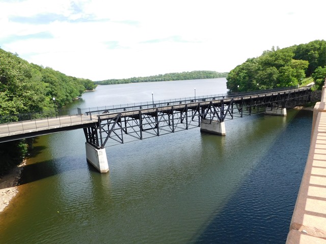
This is a rare example of a highway pin-connected truss that is mostly a deck truss, but with trusses that are outside of the deck edges rather than under the deck, and are partially positioned above the roadway elevation, although most of the trusses remain below the elevation of the roadway. Sway bracing is positioned as a deck truss. The trusses are deep, and have an unusual horizontal member running through the middle of the trusses likely for additional stability.
The bridge has been bypassed and preserved for pedestrian use.

Above: Historical view of bridge.
Information and Findings From New Jersey's Historic Bridge InventoryDiscussion of Bridge Summary: The deep, pin-connected deck truss bridge has had several modifications including concrete piers added in 1903 and numerous reinforcements and additions to the trusses beginning in 1909. The replacement of the northernmost span with two stringer spans in 1988 eliminated a difficult approach. The truss is historically significant due to its association with the boom years of Boonton. It is technologically distinctive because of its type and many of the alterations are historic changes. Physical Description: The deep three-quarter deck truss bridge, originally built as a 5-span bridge with 4 deck truss spans and one short stringer or girder span on the north end, retains four of the pin-connected deck trusses. It is composed of built-up members with the top chords, inclined end posts, and verticals are toe-out channels with lacing and cover plates; a bottom chords are stamped eye bars. Sway bracing is round eye bar with turnbuckles. The diagonals and counters are stamped eye bars with turnbuckles. The truss was originally supported by stone abutments and steel bents. The bridge, however, has been modified by a succession of additional members to strengthen the trusses and protect the piers from water damage when the reservoir was filled eight years after the bridge was constructed. Additions to the truss include a middle chord and knee braces for the floor beams, added in 1909, when the original plank deck was replaced with concrete; intermediate diagonals between the bottom and middle chord; and various riveted and bolted reinforcements. Additional diagonal tension members have been added to some panels. The riveted floor beams are apparently original, although the deck was replaced with metal deck pans on new steel stringers in 1958. Concrete piers, presumably cast around the original steel piers, were added by A. W. Edwards & Co., a local contractor, just before the reservoir was flooded in 1903. The most significant alteration was the removal of the two northernmost spans (one deck truss and one stringer or multi girder) in 1987- 1988 and replaced with two stringer spans supported by a concrete hammerhead piers to eliminate a difficult approach angle. A new concrete deck and various bolted repairs to strengthen weak truss members were made at that time. The 1988 rehabilitation was done in a sympathetic manner ensuring that the bridge would continue to function as a pin-connected span. HISTORICAL AND TECHNOLOGICAL SIGNIFICANCE: The 480' pin-connected Pratt deck truss bridge built in 1895 as a 5-span structure was considered a major accomplishment by the Canton Bridge Company. The bridge is one of two pin-connected deck truss highway bridges documented in the state making it a rare survivor of its type (Criterion C). The span has been modified quite a few times, but the work has been accomplished in a manner that has been sensitive to the original design and thus is not intrusive. The modifications do not detract from the technological significance of the span. Modifications/alterations began as early as 1903, when the concrete piers were added to protect the structure from water and/or ice damage from the new reservoir. The bridge was previously supported on high built-up steel bents. At that time jurisdiction of the piers passed to the Jersey City Water Supply Company while the superstructure remained with the county. In 1909 the bottom chords, diagonals and pins were adjusted, and the mid-chords were added. That work was designed by noted civil engineer J.A. L. Waddell. The flooring system was done in 1958, but the original built-up floor beams were retained. In 1987-1988, the northernmost 2 span were removed and replaced with modern steel stringer spans on an improved realignment. Truss members were also repaired/strengthened at that time. The 1988 work was designed by A. G. Lichtenstein & Associates for Morris County. The numerous modifications/alterations have changed the trusses from a light, traditional Pratt structure to one of much heavier proportions. Despite the alterations, most of which are either historic changes or done in a manner that is sensitive to the original design and type, the bridge is technologically distinguished because of the rarity of its type, in the depth of the trusses, and the length of the spans. The south abutment and wingwalls are documented examples of the work of Theodore Ringlieb, a local stone mason who contracted for the stonework on numerous bridges in the county. Bibliography: Robinson, E. Robinson's Atlas of Morris County. 1887. Dempsey, A.F. "Old Boonton and The Jersey City Reservoir." 1982. A Little Paper Called Boonton, Aug. 23, 1894; May 18,1895; Jun. 8, 1895; Jun. 15, 1895; Oct. 12, 1895; Oct.19, 1895; Nov. 16, 1895; Nov. 23, 1895; Dec. 7, 1895; Dec. 28, 1895; Jan 4, 1896; Jan. 18, 1896; Jan. 25,1896; Feb. 1, 1896; Mar. 28, 1896. Postcards in the collection of Jean Lee, Boonton Historical Society. Morris County Freeholders Minutes. Oct. 14, 1903; Nov. 11, 1903; April 12, 1905; June 12, 1907. "Bridge Building," The American Pictorial Monthly. June-July-August 1902. Discussion of Surrounding Area Spanning the headwaters of the Jersey City Reservoir, the bridge separates a wooded light industrial/commercial area of Parsippany Troy Hills Township from a dense residential area of Boonton Town. The bridge was part of a county improvement to provide a shorter route between Boonton and Morristown, prior to the construction of the reservoir. The Morris County Planning Board recognizes the bridge as a historic structure. Bridge Considered Historic By Survey: Yes |
![]()
![]()
![]()
Coordinates (Latitude, Longitude):
Search For Additional Bridge Listings:
Bridgehunter.com: View listed bridges within 0.5 miles (0.8 kilometers) of this bridge.
Bridgehunter.com: View listed bridges within 10 miles (16 kilometers) of this bridge.
Additional Maps:
Google Streetview (If Available)
GeoHack (Additional Links and Coordinates)
Apple Maps (Via DuckDuckGo Search)
Apple Maps (Apple devices only)
Android: Open Location In Your Map or GPS App
Flickr Gallery (Find Nearby Photos)
Wikimedia Commons (Find Nearby Photos)
Directions Via Sygic For Android
Directions Via Sygic For iOS and Android Dolphin Browser
USGS National Map (United States Only)
Historical USGS Topo Maps (United States Only)
Historic Aerials (United States Only)
CalTopo Maps (United States Only)

© Copyright 2003-2024, HistoricBridges.org. All Rights Reserved. Disclaimer: HistoricBridges.org is a volunteer group of private citizens. HistoricBridges.org is NOT a government agency, does not represent or work with any governmental agencies, nor is it in any way associated with any government agency or any non-profit organization. While we strive for accuracy in our factual content, HistoricBridges.org offers no guarantee of accuracy. Information is provided "as is" without warranty of any kind, either expressed or implied. Information could include technical inaccuracies or errors of omission. Opinions and commentary are the opinions of the respective HistoricBridges.org member who made them and do not necessarily represent the views of anyone else, including any outside photographers whose images may appear on the page in which the commentary appears. HistoricBridges.org does not bear any responsibility for any consequences resulting from the use of this or any other HistoricBridges.org information. Owners and users of bridges have the responsibility of correctly following all applicable laws, rules, and regulations, regardless of any HistoricBridges.org information.
![]()