

View Information About HSR Ratings
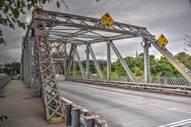
This classic highway swing bridge no longer operates for boats but its swing truss remains in good condition. The truss uses riveted connections throughout except at the swing tower, which is pin connected.
Information and Findings From New Jersey's Historic Bridge InventorySummary The thru truss rim-bearing swing span bridge on an ashlar substructure was erected in 1906 by the Owego Bridge Co. It is of riveted construction with the exception of the center tower, which has pinned top chords composed of stamped eye bars. The bridge has been altered. In 1985 the operating machinery and operator's house located above the roadway were removed. The flooring system was replaced, and additional section was bolted onto some verticals and diagonals. However, the changes do not preclude the individual eligibility of this structure for listing in the National Register of Historic Places under Criterion C as a representative example of a through truss rim-bearing span. All of the key visual elements of the bridge - the trusses by the Owego Bridge Company, the center pier, the wheels that run on a track making it a rim - bearing span, and the ashlar abutments retain integrity. Setting/Context The bridge carries a 2-lane street and sidewalks over the Passaic River at the boundary between Passaic and Bergen counties. It is located in an industrial section with car lots and an oil storage facility. Bridge Considered Historic By Survey: Yes |
![]()
![]()
![]()
Coordinates (Latitude, Longitude):
Search For Additional Bridge Listings:
Bridgehunter.com: View listed bridges within 0.5 miles (0.8 kilometers) of this bridge.
Bridgehunter.com: View listed bridges within 10 miles (16 kilometers) of this bridge.
Additional Maps:
Google Streetview (If Available)
GeoHack (Additional Links and Coordinates)
Apple Maps (Via DuckDuckGo Search)
Apple Maps (Apple devices only)
Android: Open Location In Your Map or GPS App
Flickr Gallery (Find Nearby Photos)
Wikimedia Commons (Find Nearby Photos)
Directions Via Sygic For Android
Directions Via Sygic For iOS and Android Dolphin Browser
USGS National Map (United States Only)
Historical USGS Topo Maps (United States Only)
Historic Aerials (United States Only)
CalTopo Maps (United States Only)

© Copyright 2003-2024, HistoricBridges.org. All Rights Reserved. Disclaimer: HistoricBridges.org is a volunteer group of private citizens. HistoricBridges.org is NOT a government agency, does not represent or work with any governmental agencies, nor is it in any way associated with any government agency or any non-profit organization. While we strive for accuracy in our factual content, HistoricBridges.org offers no guarantee of accuracy. Information is provided "as is" without warranty of any kind, either expressed or implied. Information could include technical inaccuracies or errors of omission. Opinions and commentary are the opinions of the respective HistoricBridges.org member who made them and do not necessarily represent the views of anyone else, including any outside photographers whose images may appear on the page in which the commentary appears. HistoricBridges.org does not bear any responsibility for any consequences resulting from the use of this or any other HistoricBridges.org information. Owners and users of bridges have the responsibility of correctly following all applicable laws, rules, and regulations, regardless of any HistoricBridges.org information.
![]()