

View Information About HSR Ratings
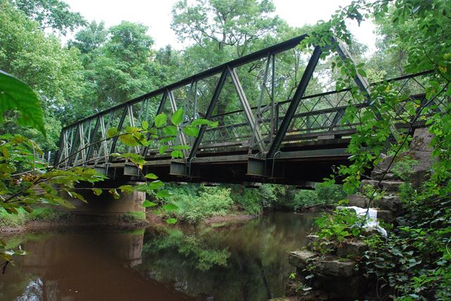
The construction date of this bridge is unknown. It has the appearance of a ca. 1905 bridge. It was built at that time in an unknown location and relocated here in 1924. It didn't quite fit on the 1869 stone abutments here, so a pier was added to hold the truss, and a steel stringer approach span was construction. This bridge is a style of bridge used in the early 20th Century where the primary rolled beam type on the bridge was angle and the primary built-up beam type was simply paired angles riveted together.
Information and Findings From Pennsylvania's Historic Bridge InventoryDiscussion of Bridge Moved to its present location in 1924, the riveted Warren pony truss appears to date to ca. 1905. It is composed of angles, set back-to-back with spacers. The top chord is braced at the panel points with a laced outrigger. There are numerous welded repairs and strengthening. The trusses were too short for the crossing, so a stringer approach span and concrete pier were added. The ashlar abutments date to 1869. The undocumented span is individually eligible for listing in the National Register of Historic Places under Criterion C. PHYSICAL DESCRIPTION The 78'-long 7-panel riveted Warren pony truss was relocated to this site in 1924. The south end of the trusses bears on a deteriorating ashlar abutment built in 1868, according to the date stone. Because the trusses were too short for the crossing, a concrete pier and rolled stringer approach span were built in 1924 to accommodate using the truss lines at this location. Both spans have a plank deck. The truss members, including the top and lower chords, are composed of angles riveted back-to-back. The inclined end posts and diagonals have washers or spacers at the rivets. The floor beams are suspended from U-bolt hangers that rest on a two-piece saddle fitted beneath what remains of the gusset plate at the panel point. The floor beams, with punched holes in the top flanges and in some webs, are hung from two U hangers with hex-headed bolts. All other connections are riveted, including the original laced knee braces with square-headed bolts. Portions of the original/early lattice railing survive on the truss spans, but it has been replaced elsewhere by modern beam guide rail barriers. There are numerous small welded repairs and strengthening to the lower portion of the trusses, and they also have impact damage. HISTORICAL AND TECHNOLOGICAL SIGNIFICANCE The present 2-span bridge over Crosswicks Creek, erected in 1924 as an intercounty (Mercer and Burlington) project, is at least the second bridge at the crossing. It utilizes the handsome but deteriorated random ashlar abutments that date to 1868. The abutments are early, complete, and documented, making them a noteworthy feature of the crossing. The date of construction and fabricator of the riveted Warren trusses is not known. They date stylistically to ca. 1905, and they exhibit no distinctive or innovative details. The trusses were moved to this site in 1924. Since they were too short for the crossing, a new concrete pier and stringer approach span were added to the north side. The trusses are not without numerous welded patches installed as repairs or strengthening. Physical evidence suggests that the flooring system has been modified, probably when the trusses were moved. The rolled I-section floor beams have punched holes in the top flanges, and some have similar holes in the web suggesting that they are salvaged material. A similar detail of hung floor beams on otherwise all rivet-connected truss bridge is the 1904 pony truss bridge at Cedar Lane in Burlington County (03D3760). The floor beam hangers are original on that bridge making it a more complete and significant example of the detail. The laced outriggers appear to be original. They are found on some other Warren pony truss bridges in the state, so this in not a rare example of the detail. The undocumented span is one of three riveted Warren pony truss spans in Mercer County. It is not as complete as the 3-span 1903 Berlin Construction Company bridge on Province Line Road (1105302). Its setting, with a modern residential subdivision at to the northwest, is also not as well preserved as the Province Line Road span. The fact that is was moved is also not unusual as Mercer County was frequently moving serviceable trusses during the 1920s. A better documented example of a moved truss within the county is the Groveville-Allentown Road span over Doctors Creek (1100028). What is unusual about the Iron Bridge Road span is the hanging of the floor beams on an otherwise all riveted bridge, but that detail is believed to be a modification rather than the original arrangement. The undocumented bridge is a representative example of a common truss type and design that appears to be too altered to retain its integrity of design. Discussion of Surrounding Area The bridge is located in the rural southeastern portion of the county on the line with Burlington County. Area immediately north of the bridge is a modern subdivision. Bridge Considered Historic By Survey: No |
![]()
![]()
![]()
Coordinates (Latitude, Longitude):
Search For Additional Bridge Listings:
Bridgehunter.com: View listed bridges within 0.5 miles (0.8 kilometers) of this bridge.
Bridgehunter.com: View listed bridges within 10 miles (16 kilometers) of this bridge.
Additional Maps:
Google Streetview (If Available)
GeoHack (Additional Links and Coordinates)
Apple Maps (Via DuckDuckGo Search)
Apple Maps (Apple devices only)
Android: Open Location In Your Map or GPS App
Flickr Gallery (Find Nearby Photos)
Wikimedia Commons (Find Nearby Photos)
Directions Via Sygic For Android
Directions Via Sygic For iOS and Android Dolphin Browser
USGS National Map (United States Only)
Historical USGS Topo Maps (United States Only)
Historic Aerials (United States Only)
CalTopo Maps (United States Only)

© Copyright 2003-2024, HistoricBridges.org. All Rights Reserved. Disclaimer: HistoricBridges.org is a volunteer group of private citizens. HistoricBridges.org is NOT a government agency, does not represent or work with any governmental agencies, nor is it in any way associated with any government agency or any non-profit organization. While we strive for accuracy in our factual content, HistoricBridges.org offers no guarantee of accuracy. Information is provided "as is" without warranty of any kind, either expressed or implied. Information could include technical inaccuracies or errors of omission. Opinions and commentary are the opinions of the respective HistoricBridges.org member who made them and do not necessarily represent the views of anyone else, including any outside photographers whose images may appear on the page in which the commentary appears. HistoricBridges.org does not bear any responsibility for any consequences resulting from the use of this or any other HistoricBridges.org information. Owners and users of bridges have the responsibility of correctly following all applicable laws, rules, and regulations, regardless of any HistoricBridges.org information.
![]()