

View Information About HSR Ratings
Bill Woodall provided this history about ownership of the bridge and railroad line: The railroad this bridge carries was built by the South Branch & Somerville Railroad in 1863-64, subsequently taken over by the Central Railroad of New Jersey. The CNJ operated this line as their Flemington or South Branch (names of branches sometimes changed over the years).
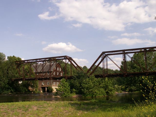
Perhaps no image better represents a traditional late 19th Century rural / small town scene in the United States than a mill next to a pin-connected truss bridge. Since the mills were built near where materials were being moved, and also by the river, they inevitably ended up next to where the area's bridge was, or alternatively, the bridge would be built in response to the mill so people on the other side of the river could bring their goods to the mill.
At least when viewed from nearby Elm Street Bridge, the scene with this railroad bridge and a historic mill in the background is largely untouched by modernization, and is an unspoiled look into what America in the late 1800s was like.
The structure consists of two spans of six panels each.
The Neshanic Station Railroad Bridge is noted by the Historic Bridge Inventory's description of the nearby Elm Street Bridge. It notes that the railroad bridge was also built in the same year as Elm Street: 1896, and that the railroad bridge is also considered historically significant. Indeed it should be, retaining excellent historic integrity and being an attractive multi-span example of its kind.
This bridge is abandoned, and overgrown at the portals with an extensive population of poison ivy. As such, on-bridge views including a traditional full detail set are not available for this bridge at this time.
![]()
![]()
![]()
Coordinates (Latitude, Longitude):
Search For Additional Bridge Listings:
Bridgehunter.com: View listed bridges within 0.5 miles (0.8 kilometers) of this bridge.
Bridgehunter.com: View listed bridges within 10 miles (16 kilometers) of this bridge.
Additional Maps:
Google Streetview (If Available)
GeoHack (Additional Links and Coordinates)
Apple Maps (Via DuckDuckGo Search)
Apple Maps (Apple devices only)
Android: Open Location In Your Map or GPS App
Flickr Gallery (Find Nearby Photos)
Wikimedia Commons (Find Nearby Photos)
Directions Via Sygic For Android
Directions Via Sygic For iOS and Android Dolphin Browser
USGS National Map (United States Only)
Historical USGS Topo Maps (United States Only)
Historic Aerials (United States Only)
CalTopo Maps (United States Only)

© Copyright 2003-2024, HistoricBridges.org. All Rights Reserved. Disclaimer: HistoricBridges.org is a volunteer group of private citizens. HistoricBridges.org is NOT a government agency, does not represent or work with any governmental agencies, nor is it in any way associated with any government agency or any non-profit organization. While we strive for accuracy in our factual content, HistoricBridges.org offers no guarantee of accuracy. Information is provided "as is" without warranty of any kind, either expressed or implied. Information could include technical inaccuracies or errors of omission. Opinions and commentary are the opinions of the respective HistoricBridges.org member who made them and do not necessarily represent the views of anyone else, including any outside photographers whose images may appear on the page in which the commentary appears. HistoricBridges.org does not bear any responsibility for any consequences resulting from the use of this or any other HistoricBridges.org information. Owners and users of bridges have the responsibility of correctly following all applicable laws, rules, and regulations, regardless of any HistoricBridges.org information.
![]()