

View Information About HSR Ratings
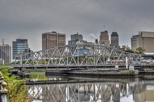
This swing bridge is noted for its rare curved top chord and vertical end posts.
Information and Findings From New Jersey's Historic Bridge InventorySummary The rim-bearing Pratt thru truss swing span bridge is supported on an ashlar substructure with concrete caps. In 1981 the east gate house was removed, a new overhead control house was erected, and the operation was rendered fully automated. The trusses were also repaired. One of three operational rim-bearing swing spans in the industrial heart of Newark, the span is evaluated as significant based on its type and historical associations despite alterations. Setting/Context The bridge carries a 2-lane road and sidewalks over a major river in the center of Newark. The structures around the bridge are mainly industrial and commercial and date from the 1900s through the 1970s. Physical Description The rim bearing swing-span bridge is composed of a riveted Pratt with counters thru truss with curved top chords swing span, and two built-up deck girder approach spans. The bridge measures 371' in length and carries a 39' roadway and 2 cantilevered sidewalks. The top chords are built-up back-to-back channels connected by lattice at the bottom and a cover plate at the top. The diagonal members and the bottom chord are back-to-back channels connected by lacing. The vertical members are built-up with two pairs of back-to-back angles separated by lacing. The sidewalks are flanked by modern 3-rail metal railings. Some of the members, particularly the outside panel members, have been strengthened by additional plates connected with high-strength bolts. The bridge was rehabilitated in 1981, and although much of the operating machinery and gearing were replaced, some of the new fabric is inkind replacement, and the span still operates in the original manner. The electrical system was completely updated in 1981 as were the operating controls and operator's house, located adjacent to one quadrant of the span. The movable span rotates on wheels affixed to the bottom of the drum girder and inside the rack. While the rack, pinion, and bevel drive gear sets appear to be 1981 replacements, they are inkind and in the original locations. The operation of the bridge was automated in 1981 so that the entire process was performed by engaging a single switch. The automated process was disengaged because the process could not be halted when problems arose. The built-up radials located inside the drum and connected to the center pin and pedestal have web plates. The bearings are now the screw jack type, and they too were installed in 1981. Other 1981 work includes welded floor beams added to the deck girder approach spans and concrete caps added to the ashlar abutments and wingwalls. The bridge deck and stringers were replaced, and the timber fender system was repaired. Historical and Technological Significance The 1912 swing-span bridge, located in the industrial heart of Newark, was designed by the county engineer and constructed by the American Bridge Company. The bridge is technologically significant because it is an operating example of an increasingly rare bridge type. It is one of only four known rim bearing swing-span bridges in the county, and it is one of three with curved top chords and curved tops to the end posts. The truss design was popular locally and may well have been done by James Owens, the Essex County Engineer and his staff (Criterion C). In addition to its technological significance, the bridge is associated with the industrial development of Newark, one of the leading industrial centers of the region prior to World War II. The bridge was rehabilitated in 1981, and although some of the work to it resulted in the loss of historic fabric, particularly in the area of the controls and power source, the bridge retains enough of its original material and design to rank as one of the noteworthy swing spans in the state. The bridge is a rim-bearing rather than a center bearing because of its size. Boundary Description and Justification The boundary is limited to the swing span and the substructure related to it (pivot pier and rest piers). The approach spans have been so altered that they have lost integrity of original design. Since it is the technology of the swing span that is being recognized, it is appropriate to limit the boundary to just that span. Sources Bibliography: Essex County Engineers Office. (Plans) Essex County Board of Chosen Freeholders Minutes. Bridge Considered Historic By Survey: Yes |
![]()
![]()
![]()
Coordinates (Latitude, Longitude):
Search For Additional Bridge Listings:
Bridgehunter.com: View listed bridges within 0.5 miles (0.8 kilometers) of this bridge.
Bridgehunter.com: View listed bridges within 10 miles (16 kilometers) of this bridge.
Additional Maps:
Google Streetview (If Available)
GeoHack (Additional Links and Coordinates)
Apple Maps (Via DuckDuckGo Search)
Apple Maps (Apple devices only)
Android: Open Location In Your Map or GPS App
Flickr Gallery (Find Nearby Photos)
Wikimedia Commons (Find Nearby Photos)
Directions Via Sygic For Android
Directions Via Sygic For iOS and Android Dolphin Browser
USGS National Map (United States Only)
Historical USGS Topo Maps (United States Only)
Historic Aerials (United States Only)
CalTopo Maps (United States Only)

© Copyright 2003-2024, HistoricBridges.org. All Rights Reserved. Disclaimer: HistoricBridges.org is a volunteer group of private citizens. HistoricBridges.org is NOT a government agency, does not represent or work with any governmental agencies, nor is it in any way associated with any government agency or any non-profit organization. While we strive for accuracy in our factual content, HistoricBridges.org offers no guarantee of accuracy. Information is provided "as is" without warranty of any kind, either expressed or implied. Information could include technical inaccuracies or errors of omission. Opinions and commentary are the opinions of the respective HistoricBridges.org member who made them and do not necessarily represent the views of anyone else, including any outside photographers whose images may appear on the page in which the commentary appears. HistoricBridges.org does not bear any responsibility for any consequences resulting from the use of this or any other HistoricBridges.org information. Owners and users of bridges have the responsibility of correctly following all applicable laws, rules, and regulations, regardless of any HistoricBridges.org information.
![]()