

View Information About HSR Ratings
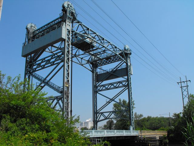
This bridge is one of three vertical lifts along this section of roadway. The bridges are excellent representative examples of medium-sized vertical lift bridges. Having smaller spans than the large vertical lift bridges such as those seen in Chicago, or on the Welland Canal in Ontario, the main lift span is not a through truss, but is instead a through plate girder. These bridges are noteworthy New Jersey examples of the smaller lift bridges seen in places such as southern Louisiana. The Historic Bridge Inventory for New Jersey provides an extensive narrative for the bridge below.
Aesthetically, the bridges are noted for their attractive railings. Although the approach spans have concrete railings and the main span has steel railings, they have the same pierced openings that provide a consistent appearance. The approach spans are steel stringer spans but include a concrete encasement to give the appearance of concrete beams.
The Nortonville Bridge no longer operates for boat traffic. The abandoned bridgetender building remains next to the bridge.
Information and Findings From New Jersey's Historic Bridge InventorySummary The bridge's main span is a vertical lift with a thru-girder deck, steel towers with portal bracing and lateral stiffening trusses, wire rope lift cables, concrete counterweights with plate girder frames, and central overhead machinery house. The three approach spans are encased steel stringers with concrete balustrades. The bridge is one of three similar Waddell-type, vertical-lift bridges on old NJ 44 in Gloucester and Salem counties. All three are eligible. Physical Description The two-lane bridge is a single-span movable Waddell-type vertical lift with three encased steel stringer approach spans. Its overall length is 228' with a 40' roadway. The main vertical lift span consists of a single, 92'-long toe-to-toe, 7'-deep thru girder with floor beams. The span is constructed to permit it being lifted vertically to a height of 64' clear above mean low water. At each end of the main span are steel towers approximately 96'-high. Each tower consists of two legs with horizontal and diagonal sway bracing. Between the tops of the opposite towers pass two trusses, and suspended between the trusses is the central overhead machinery house. The towers and bracing are all riveted angles, channels, and beams steel construction. Cantilevered off both sides of the main span are concrete deck sidewalks with sheet metal balustrades. The main span is no longer operable. Power for lifting the bridge is supplied from the central overhead machinery house that contained an electric motor and a back-up gas engine. At the top of each of the four tower legs are sheaves over which pass steel-wire ropes. The ropes are attached at one end to counterweights and at the other to couplings attached to the roadway. Power was transmitted from the motor to the sheave coupling by means of direct drive line shafting and gears. The span moved up and down along a C-shaped guide on the interior of the tower legs. The machinery was equipped with electric motor brakes and clutch. The two counterweights consist of concrete blocks held within riveted steel plate frames on the exterior side of the tower legs. The approach spans are concrete encased steel stringers with concrete balustrades and sidewalks. There are three approach spans, two to the north and one to the south of the main span, each approximately 45'-long. The bridge has a concrete substructure with cutwater piers. The fenders are timber piling. At each end of the main span are safety gates original to the bridge construction. East of the south approach is a square-plan, single-story, 2-bay, poured concrete operator's house with hipped roof. Historical and Technological Significance The vertical lift bridge across Oldmans Creek is a well-preserved, albeit no longer operable, example of a historically and technologically significant bridge type. The vertical lift type represented important advances in structural steel construction, and was an alternative to bascule and swing span type movable bridges. The Oldmans Creek Bridge is one of three vertical lifts along old New Jersey Highway Route 44 in Salem and Gloucester Counties. All three bridges, built between 1935 and 1940, have been recommended as eligible because they represent an increasingly rare early 20th-century bridge type. Vertical lift bridges are a special bridge type combining both mechanical and civil engineering technologies. The first vertical lift bridge of importance in the United States was designed by well-known bridge engineer, J. A. L. Waddell. In 1894 he oversaw the construction of the South Halsted Street Bridge over the Chicago River in Chicago, Illinois. The bridge, which had overhead trusses between the towers and sheaves at the top of each tower leg, became known as the Waddell-type vertical lift. Beginning in 1908 vertical lift bridges were built in increasing numbers, often replacing swing-span type movable bridges. According to bridge engineer H. E. Pulver (1923) the advantages of the vertical lift included simplicity of design, rigidity, reliability, ease of operation, short time of operation (usually 40-50 seconds), power economy, cost of operation, and less chance of collision with boats. The bridge type was particularly suitable to long span crossings where high navigational clearance was required. The Oldmans Creek Bridge was built in 1936 as part of the reconstruction of NJ Highway Route 44. The firm of Ash, Howard, Needles, and Tammen of New York and Kansas City acted as consulting engineers on the New Deal public works project. The bridge was sealed to navigation in the late 1960s when South Jersey's declining maritime economy no longer made a movable span on Oldmans Creek necessary. No record of repairs or alterations to the original bridge structure could be located. Plans indicate that the bridge was built with light standards and lanterns. over Mantua Creek in Paulsboro (0806150), is nearly identical to the Oldmans Creek Bridge. It is still operable and has been outfitted with new operating machinery and operator's house. The youngest bridge, US 130 over Raccoon Creek (0807151) is also operable. It is of different construction and has been retrofitted with machinery and a new operator's house. As a group the bridges are neither the oldest or largest of their type in the United States, however, they are significant engineering achievements representing the application of vertical lift bridge technology to medium-span crossings. Sources New Jersey State Highway Commission, Division of
Bridges, Oldmans Creek Bridge
Plans, 1936.
Discussion of Surrounding Area The two-lane bridge spans Oldmans Creek about 7/10 mile east of the Delaware River. On the southeast creek bank is the original poured concrete operator's house. The bridge no longer opens to river navigation. Nearby are numerous earthen dikes to protect farmer's fields from flooding. About 1 mile to the west on the horizon is a chemical factory. Bridge Considered Historic By Survey: Yes, and Evaluated in Management Plan |
![]()
![]()
![]()

![]()
Coordinates (Latitude, Longitude):
Search For Additional Bridge Listings:
Bridgehunter.com: View listed bridges within 0.5 miles (0.8 kilometers) of this bridge.
Bridgehunter.com: View listed bridges within 10 miles (16 kilometers) of this bridge.
Additional Maps:
Google Streetview (If Available)
GeoHack (Additional Links and Coordinates)
Apple Maps (Via DuckDuckGo Search)
Apple Maps (Apple devices only)
Android: Open Location In Your Map or GPS App
Flickr Gallery (Find Nearby Photos)
Wikimedia Commons (Find Nearby Photos)
Directions Via Sygic For Android
Directions Via Sygic For iOS and Android Dolphin Browser
USGS National Map (United States Only)
Historical USGS Topo Maps (United States Only)
Historic Aerials (United States Only)
CalTopo Maps (United States Only)

© Copyright 2003-2024, HistoricBridges.org. All Rights Reserved. Disclaimer: HistoricBridges.org is a volunteer group of private citizens. HistoricBridges.org is NOT a government agency, does not represent or work with any governmental agencies, nor is it in any way associated with any government agency or any non-profit organization. While we strive for accuracy in our factual content, HistoricBridges.org offers no guarantee of accuracy. Information is provided "as is" without warranty of any kind, either expressed or implied. Information could include technical inaccuracies or errors of omission. Opinions and commentary are the opinions of the respective HistoricBridges.org member who made them and do not necessarily represent the views of anyone else, including any outside photographers whose images may appear on the page in which the commentary appears. HistoricBridges.org does not bear any responsibility for any consequences resulting from the use of this or any other HistoricBridges.org information. Owners and users of bridges have the responsibility of correctly following all applicable laws, rules, and regulations, regardless of any HistoricBridges.org information.
![]()