

View Information About HSR Ratings
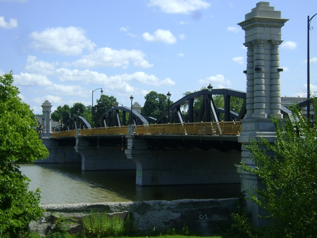
This multi-span pony truss with impressive decorative columns was widened, turning the trusses into non-structural elements, but the bridge remains an attractive landmark. The decorative towers are not original (the originals were removed years ago, before the 2001 project).
A good idea for this type of project, a plaque was installed which informs visitors of the past and current bridge width as seen today, letting people know the appearance today is not original.
The approach span shown here as a plate girder was demolished and replaced with a steel stringer span in 2001. There also was a through plate girder over a railroad that was removed in the 1970s. Dimensions given show the truss spans and bridge length as originally constructed, but the roadway width is as seen today. The original roadway width was 39 feet. National Bridge Inventory sheet on this page has information for bridge both prior and after alteration. For a number of years, this bridge had an steel open grate deck (not original).
The builder for this bridge was referenced here.
Information From Cultural Resources Information System:
Three Warren pony truss spans, each approximately 128' long, supported on two mid-channel piers. 462' long overall with approach decks, 50' inside curbs, sidewalks on both sides outboard of trusses. Decorative tower at river bank on all four corners. The bridge was rehabbed in 2001. The rehab project included highway improvements, historic restoration and the widening of the bridge. The widening was performed under staged construction to provide a minimum of one lane of traffic at all times during construction. The truss spans were widened by removing the existing floorbeam/stringer system and placing a new 3-span continuous deck girder bridge. The trusses, cantilevered walkways and railings were removed, rehabilitation and reset (lateral support of the trusses was provided by the new bridge). Complete superstructure replacement was required for the 73' long deck girder approach structures. Twenty-five foot tall precast architectural end pylons were designed to replicate the original pylons that had been removed under previous improvement projects. Ornamental lighting fixtures were provided on the bridges and approaches. Landscaping improvements to an adjacent park were performed. Improvements included planting, ornamental concrete walls and pylons, stamped concrete pavement and ornamental lighting.
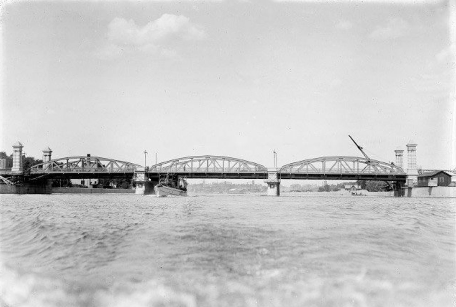
Above: Historical photo showing bridge construction in 1917.

Above: Historical photo showing bridge construction in 1917.

Above: Historical ca. 1917 of previous bridge at this location.

Above: Historical photo showing earlier bridge at this location, reportedly the second bridge.
This bridge is tagged with the following special condition(s): Trusses Converted To Decorative and Unorganized Photos
![]()
![]()
![]()
Coordinates (Latitude, Longitude):
Search For Additional Bridge Listings:
Bridgehunter.com: View listed bridges within 0.5 miles (0.8 kilometers) of this bridge.
Bridgehunter.com: View listed bridges within 10 miles (16 kilometers) of this bridge.
Additional Maps:
Google Streetview (If Available)
GeoHack (Additional Links and Coordinates)
Apple Maps (Via DuckDuckGo Search)
Apple Maps (Apple devices only)
Android: Open Location In Your Map or GPS App
Flickr Gallery (Find Nearby Photos)
Wikimedia Commons (Find Nearby Photos)
Directions Via Sygic For Android
Directions Via Sygic For iOS and Android Dolphin Browser
USGS National Map (United States Only)
Historical USGS Topo Maps (United States Only)
Historic Aerials (United States Only)
CalTopo Maps (United States Only)

© Copyright 2003-2024, HistoricBridges.org. All Rights Reserved. Disclaimer: HistoricBridges.org is a volunteer group of private citizens. HistoricBridges.org is NOT a government agency, does not represent or work with any governmental agencies, nor is it in any way associated with any government agency or any non-profit organization. While we strive for accuracy in our factual content, HistoricBridges.org offers no guarantee of accuracy. Information is provided "as is" without warranty of any kind, either expressed or implied. Information could include technical inaccuracies or errors of omission. Opinions and commentary are the opinions of the respective HistoricBridges.org member who made them and do not necessarily represent the views of anyone else, including any outside photographers whose images may appear on the page in which the commentary appears. HistoricBridges.org does not bear any responsibility for any consequences resulting from the use of this or any other HistoricBridges.org information. Owners and users of bridges have the responsibility of correctly following all applicable laws, rules, and regulations, regardless of any HistoricBridges.org information.
![]()