

View Information About HSR Ratings

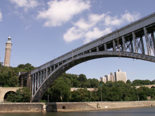
This bridge was originally a fifteen span stone arch bridge, completed in 1848 to carry the first Croton Aqueduct, now known as the Old Croton Aqueduct, which brought fresh water to a growing city that needed it badly. In 1860, the bridge deck was increased in height to accommodate additional piping for more water. In 1872, the distinctive High Bridge Watchtower, which remains today, was constructed to control the water pressure. By World War I, methods of bringing water to the city through underground means were in place, and the aqueduct was shut down for water purposes for war-related security reasons. In the 1920s, something happened that much resembles the sort of threats and solutions that occur with historic bridges today. The Army Corp of Engineers decided to complain about the horizontal clearance of the bridge and demanded the bridge either be remodeled or demolished. The city of New York supported demolition since by this time the structure served as nothing more than a footbridge. However many citizens and organizations saw the stone arch bridge which was now around 70 years old, as a historic landmark. They pressured the city into a compromise where five of the largest stone arch spans (all the Harlem River spans) were demolished and a steel deck arch bridge with sufficient horizontal clearance was built and opened in 1927. In the 1960s, the bridge was closed to pedestrian traffic, and to this day the bridge remains abandoned, despite possible talk and funding for a restoration project.

During the time since the 1927 alteration the steel deck arch bridge is today, along with the remaining stone arch spans, a structure with noteworthy historic significance and a high level of aesthetic value. The remaining stone arch bridge spans which serve as an approach for this steel arch span are also extremely significant in their own right. They are a significant stone arch bridge, indeed among the largest stone arch bridges in the United States. With an 1848 construction date, they are also extremely old examples of stone arch construction in the United States as well, which also adds to the "engineering achievement" value of the bridge, to have built such a large bridge so long ago. In addition, the stone arch spans are significant as a part of a larger engineering achievement of the time, the Old Croton Aqueduct, a structure that made possible the growth of New York City. The arch spans of this bridge are also locally significant as the oldest remaining bridge structure in all of New York City.
More information is available here.


![]()
![]()
![]()
Coordinates (Latitude, Longitude):
Search For Additional Bridge Listings:
Bridgehunter.com: View listed bridges within 0.5 miles (0.8 kilometers) of this bridge.
Bridgehunter.com: View listed bridges within 10 miles (16 kilometers) of this bridge.
Additional Maps:
Google Streetview (If Available)
GeoHack (Additional Links and Coordinates)
Apple Maps (Via DuckDuckGo Search)
Apple Maps (Apple devices only)
Android: Open Location In Your Map or GPS App
Flickr Gallery (Find Nearby Photos)
Wikimedia Commons (Find Nearby Photos)
Directions Via Sygic For Android
Directions Via Sygic For iOS and Android Dolphin Browser
USGS National Map (United States Only)
Historical USGS Topo Maps (United States Only)
Historic Aerials (United States Only)
CalTopo Maps (United States Only)

© Copyright 2003-2024, HistoricBridges.org. All Rights Reserved. Disclaimer: HistoricBridges.org is a volunteer group of private citizens. HistoricBridges.org is NOT a government agency, does not represent or work with any governmental agencies, nor is it in any way associated with any government agency or any non-profit organization. While we strive for accuracy in our factual content, HistoricBridges.org offers no guarantee of accuracy. Information is provided "as is" without warranty of any kind, either expressed or implied. Information could include technical inaccuracies or errors of omission. Opinions and commentary are the opinions of the respective HistoricBridges.org member who made them and do not necessarily represent the views of anyone else, including any outside photographers whose images may appear on the page in which the commentary appears. HistoricBridges.org does not bear any responsibility for any consequences resulting from the use of this or any other HistoricBridges.org information. Owners and users of bridges have the responsibility of correctly following all applicable laws, rules, and regulations, regardless of any HistoricBridges.org information.
![]()