HistoricBridges.org Menu: HistoricBridges.org Menu:


We Recommend:
Bach Steel - Experts at historic truss bridge restoration.

HistoricBridges.org: Bridge Browser

Kosciuszko Bridge

Meeker Avenue Bridge

Kosciuszko Bridge

Primary Photographer(s): Nathan Holth

Bridge Documented: October 19-20, 2013

View Photos
and Videos
View Maps
and Links

Location
New York: Brooklyn, New York and Queens, New York: United States
Structure Type
Metal 12 Panel Rivet-Connected Polygonal Warren Through Truss, Fixed and Approach Spans: Metal 9 Panel Rivet-Connected Warren Deck Truss, Fixed
Construction Date and Builder / Engineer
1939 By Builder/Contractor: American Bridge Company of New York, New York and Engineer/Design: J. Frank Johnson
Rehabilitation Date
1966
Main Span Length
300.0 Feet (91.4 Meters)
Structure Length
5,536.0 Feet (1687.4 Meters)
Roadway Width
78.7 Feet (23.99 Meters)
Spans
1 Main Span(s) and 102 Approach Span(s)
Inventory Number
1075699

Historic Significance Rating (HSR)
View Information About HSR Ratings

Bridge Documentation

This bridge no longer exists!

View Archived National Bridge Inventory Report - Has Additional Details and Evaluation

This historic bridge was demolished and replaced in 2017!

Download a ZIP Archive of Selected Final Environmental Impact Statement Documents

View The Historic Resource Inventory Form For This Historic Bridge

View The Final Determination of Eligibility For This Historic Bridge

View Historical Articles About This Bridge

This bridge is a large high level bridge that includes a substantial approach system The bridge includes 10 deck truss spans on the Brooklyn end and 11 deck truss spans on the Queens end. The remaining approach spans are concrete slabs and are part of the connecting viaduct approaches to the bridge. The abutments and viaduct approaches for this bridge are unusual since they are enclosed and faced in red brick, which makes these portions of the bridge look like something from England where such structures are often found. These portions of the "bridge" are not part of the bridge proper however, which is defined by the start of the deck truss spans. However, most sources listing the total length of the bridge appear to include these viaducts in the length measurement.

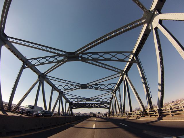
This bridge was found eligible for listing in the National Register of Historic Places for its engineering significance. The bridge is unique in both design and appearance. Perhaps one of the unusual aspects of this bridge's design is that for a bridge that provides such high clearance for boats, the actual span length of the navigation span (the through truss) is not very substantial at only 300 foot. Where other bridges offering similar navigation vertical clearance might be large cantilever trusses with spans in excess of 500 feet, this bridge's comparatively modest 300 foot span is accommodated by a traditional simple span through truss. This unexpected layout gives this bridge a unique appearance. Another unusual aspect of this bridge is the width of its roadway. With six lanes and only two truss lines, its through truss is very wide compared to most riveted truss bridges. The bridge is also noted for its curved design. The curves add to the engineering complexity of the bridge, and also make for some interesting photos.

As the only interesting structural part of the bridge easily visible to those driving over the bridge is the through truss, many people may never have taken the journey down to the industrial areas under this bridge to appreciate the complexity and beauty of this bridge. Sadly, this bridge was mostly known among the general for its major traffic jams. The bridge is not as busy on Sundays however, which is when HistoricBridges.org documented it. An unfortunate side effect of this is that the fact that traffic was actually moving on the bridge making it impossible to get a decent photo of the bridge's plaques, mounted on the portal bracing of the through truss.

This bridge is unfortunately to be replaced and demolished by a modern bridge that will be devoid of historic significance.

The below photo which was taken in the nearby Calvary Cemetery which offers a good overview of the truss spans of the bridge and is perhaps a fitting photo to conclude this narrative given the fate of this historic bridge. Unlike the gravestones that stand here to remind us of the past, there will be nothing left of the historic Kosciuszko Bridge after it is reduced to scrap metal.

Main Plaque

CITY OF NEW YORK
FIORELLO H. LA GUARDIA
MAYOR

KOSCIUSZKO BRIDGE

DESIGNED AND SUPERVISED BY THE
DEPARTMENT OF PUBLIC WORKS

IRVING V. A. HUIE
COMMISSIONER
    1939     J. FRANK JOHNSON
CHIEF ENGINEER

Information and Findings From Final Environmental Impact Statement

Discussion of Bridge

The Kosciuszko Bridge over Newtown Creek. The Penny Bridge was considered inadequate by the mid-1920s, and discussions of another replacement bridge began to circulate. The commercial and industrial enterprises in the area continued to grow, and the daily use of the Penny Bridge increased significantly. The bridge's need to allow for waterway traffic to pass by would cause back-ups with the vehicular traffic as it waited for the bridge to turn back landwards. In addition, the design of the Penny Bridge caused "bottlenecks" on the creek. The process of ships passing through the creek by the Penny Bridge was difficult because of the width of the creek at that point, a mere 144 feet wide. "The bridge ahead, like a turnstile, pivots on an island one-third as wide as the waterway...the creek ...cannot be deepened there [because] the bridge foundations would collapse" (Brooklyn Eagle, August 4, 1939a:13). Local businessmen and the Borough Chamber hoped a new bridge would allow the creek to be widened considerably at this location and allow for a substantial increase in business for industries in both Queens and Brooklyn.

The Brooklyn Borough President Henry Hesterberg introduced the first official proposal for a new span in 1930. The new bridge was to be built as part of an expansive interborough express highway that was to "extend from Grand Army Plaza, Brooklyn, to the Astoria Boulevard approach of the Triborough Bridge, in Queens" (New York Times, July 13, 1930:25). The new bridge was designed as a moveable structure at the behest of the War Department to allow "the passage of high-masted ships. The cost of building it high enough as a fixed bridge to gain the sanction of the War department was prohibitive" (New York Times, July 13, 1930:25). However, this proposal was not funded, and the Penny Bridge continued in its capacity. A second proposal, submitted by Mayor Fiorello LaGuardia to the Public Works Administration (PWA) in 1935, requested $1 billion worth of work in New York City to cover construction of new schools, parks, housing projects, road construction, and a new bridge over Newtown Creek (New York Times, February 11, 1935:1). The cost of the bridge was estimated to be $2.6 million. The PWA did not immediately provide funding for the bridge, but city officials fully anticipated that the construction of the new bridge at Meeker Avenue would be executed at some point and planned other projects based on that assumption.

The planning for the 1939 World's Fair at Flushing Meadow, Queens began in 1936, and the city aggressively initiated road improvement projects to handle the anticipated crowds for the exhibition. In 1937, the approval for construction of the crosstown Brooklyn highway (Brooklyn-Queens Expressway) described the route as extending from "Flushing Avenue and Emerson Place to the proposed new Newtown Creek Bridge at Meeker Avenue" (New York Times, March 6, 1937:19). Funding for the new bridge finally became available in 1938, and construction started that year (New York Times, August 18, 1938:21). The bridge was completed within the year and was officially dedicated by LaGuardia and the borough presidents in August 1939. Critics of the city's spending on the World's Fair identified the Meeker Avenue Bridge as one of the core improvements constructed specifically for the Fair. However, LaGuardia was quick to point out that "this bridge has been under consideration for 15 years. It has nothing to do with the city's participation in the Fair" (Brooklyn Eagle, August 24, 1939b:26). The following year, the Meeker Avenue Bridge was renamed the Koscisuzko Bridge in honor of General Thaddeus Kosciuszko.

Thaddeus Kosciuszko (1746-1817) was a native of Poland and attended the Cadet Academy in Warsaw before continuing his studies in engineering in Paris. Kosciuszko arrived in Philadelphia in 1776 and was commissioned as Colonel of Engineers in the Continental Army in October (Polish American Cultural Center 2005). Kosciuszko's responsibilities included fortification of the Philadelphia waterfront and the Hudson River, and the defense of Saratoga, New York. In addition, Kosciuszko was responsible for the design and construction of the fortification at West Point, New York (National Park Service 2005). Appointed Brigadier General in 1783, Kosciuszko was presented with the Cincinnati Order Medal by General Washington in recognition of his contributions to the Revolution. Upon returning to Poland in 1784, Kosciuszko was involved with the 1794 insurrection against the foreign occupying forces in Poland. He was captured by the Russians, and upon his release returned to the United States in 1797 (National Park Service 2005). Kosciuszko was close friends with Thomas Jefferson and spent a number of years in Philadelphia before returning to Europe in 1816. At the age of 72, Kosciuszko died in Switzerland (Polish American Cultural Center 2005).

The design of the Kosciuszko Bridge was executed through the City of New York's Department of Plant and Structure/Department of Public Works. Due to the extensive number of cargo ships, freighters, and other vessels that utilized Newtown Creek, the bridge was required to be high enough to allow for ships to pass underneath. The steel bridge soared 125 feet above the creek at its highest point, and its length from tower to tower was long enough to allow the creek to be widened to 250 feet or more (Brooklyn Eagle, August 4, 1939a:13). The Brooklyn Eagle boasted in its August 4, 1939 edition that the bridge was "384 feet longer than the Brooklyn Bridge" and due to ground instability at the Brooklyn side, "bigger, wider foundations" were required. On the Queens side, the foundations were "oversized" and coated with a "special acid-proof compound" as a result of the discovery of copper slag, sulphur compounds, and acids in the ground. It was also reported that the construction of the bridge required an "ingenious new method of laying and forming the 12,800 feet of concrete roadway" (Brooklyn Eagle, August 4, 1939a:13).

In a 1951 interview with Emil Praeger, the Brooklyn Eagle identifies Praeger as the chief engineer for the bridge. He stated that the Kosciuszko Bridge was the "first example in this city where a prefabricated steel surface had been used. He explained it would not damage automobile tires more than the average pavement. He added that horses could walk on it safely," (Brooklyn Daily Eagle 1951: Bridge File 0184-0197, Photograph BRID 0192). With the exception of this 1951 article, no additional documentation confirms Praeger's association with the design and execution of the Kosciuszko Bridge. According to the dedication plaque located on the bridge, J. Frank Johnson of the Department of Public Works is listed as the chief engineer.

Divider

Photo Galleries and Videos: Kosciuszko Bridge


View Photo Gallery

Bridge Photo-Documentation

Original / Full Size Photos
A collection of overview and detail photos. This gallery offers photos in the highest available resolution and file size in a touch-friendly popup viewer.
Alternatively, Browse Without Using Viewer

Divider

View Photo Gallery

Bridge Photo-Documentation

Mobile Optimized Photos
A collection of overview and detail photos. This gallery features data-friendly, fast-loading photos in a touch-friendly popup viewer.
Alternatively, Browse Without Using Viewer

Divider

View Photo Gallery

CarCam Photos

Original / Full Size Photos
A collection of photos taken with a wide angle GoPro camera showing the experiance of driving over the bridge. This gallery offers photos in the highest available resolution and file size in a touch-friendly popup viewer.
Alternatively, Browse Without Using Viewer

Divider

View Photo Gallery

CarCam Photos

Mobile Optimized Photos
A collection of photos taken with a wide angle GoPro camera showing the experiance of driving over the bridge. This gallery features data-friendly, fast-loading photos in a touch-friendly popup viewer.
Alternatively, Browse Without Using Viewer

Divider

Maps and Links: Kosciuszko Bridge

This historic bridge has been demolished. This map is shown for reference purposes only.

Coordinates (Latitude, Longitude):

Search For Additional Bridge Listings:

Bridgehunter.com: View listed bridges within 0.5 miles (0.8 kilometers) of this bridge.

Bridgehunter.com: View listed bridges within 10 miles (16 kilometers) of this bridge.

HistoricBridges.org Bridge Browser: View listed bridges within 0.5 miles (0.8 kilometers) of this bridge.

HistoricBridges.org Bridge Browser: View listed bridges within 10 miles (16 kilometers) of this bridge.

2021 National Bridge Inventory: View listed bridges within 0.5 miles (0.8 kilometers) of this bridge.

Additional Maps:

Google Maps

Google Streetview (If Available)

Bing Maps

OpenStreetMap

GeoHack (Additional Links and Coordinates)

Apple Maps (Via DuckDuckGo Search)

Apple Maps (Apple devices only)

MapQuest

HERE We Go Maps

ACME Mapper

Waze Map

Android: Open Location In Your Map or GPS App

Flickr Gallery (Find Nearby Photos)

Wikimedia Commons (Find Nearby Photos)

Directions Via Sygic For Android

Directions Via Sygic For iOS and Android Dolphin Browser

USGS National Map (United States Only)

Historical USGS Topo Maps (United States Only)

Historic Aerials (United States Only)

CalTopo Maps (United States Only)


Divider
 
Home Top

Divider

About - Contact

© Copyright 2003-2024, HistoricBridges.org. All Rights Reserved. Disclaimer: HistoricBridges.org is a volunteer group of private citizens. HistoricBridges.org is NOT a government agency, does not represent or work with any governmental agencies, nor is it in any way associated with any government agency or any non-profit organization. While we strive for accuracy in our factual content, HistoricBridges.org offers no guarantee of accuracy. Information is provided "as is" without warranty of any kind, either expressed or implied. Information could include technical inaccuracies or errors of omission. Opinions and commentary are the opinions of the respective HistoricBridges.org member who made them and do not necessarily represent the views of anyone else, including any outside photographers whose images may appear on the page in which the commentary appears. HistoricBridges.org does not bear any responsibility for any consequences resulting from the use of this or any other HistoricBridges.org information. Owners and users of bridges have the responsibility of correctly following all applicable laws, rules, and regulations, regardless of any HistoricBridges.org information.

Admin Login

Divider