

View Information About HSR Ratings
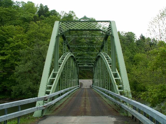
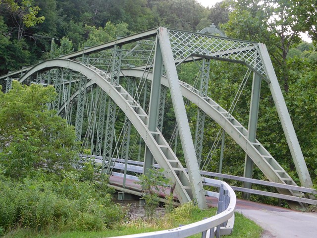
This is a nine panel through truss that features a fairly impressive length span. This bridge is built to the same design the Groton Bridge Company used on bridges like the Bridge Street Bridge in Portland, Michigan. Similarities to note between the two structures are the same unusually shaped sway bracing, and use of latticed verticals. The general design of the portal bracing is the same, although the Bridge Street Bridge's portal bracing is not as large. They also share the same design builder plaque.
The Landers Corners Road Bridge had an arch added to it in 1985 which essentially rendered the trusses decorative, since the arch does the load bearing. As a result, this bridge actually appears in the National Bridge Inventory as a pre-1900 through arch. This is misleading; the trusses date to 1890, but the arch dates to 1985. The use of these arches has been employed on some other truss bridges. Because it alters the function of the superstructure, and also because it is rather unsightly, the use of these sorts of retrofits should only be considered when all other preservation options have been exhausted and the only remaining option is demolition.
This bridge is tagged with the following special condition(s): Trusses Converted To Decorative and Unorganized Photos
![]()
![]()
![]()
![]()
Coordinates (Latitude, Longitude):
Search For Additional Bridge Listings:
Bridgehunter.com: View listed bridges within 0.5 miles (0.8 kilometers) of this bridge.
Bridgehunter.com: View listed bridges within 10 miles (16 kilometers) of this bridge.
Additional Maps:
Google Streetview (If Available)
GeoHack (Additional Links and Coordinates)
Apple Maps (Via DuckDuckGo Search)
Apple Maps (Apple devices only)
Android: Open Location In Your Map or GPS App
Flickr Gallery (Find Nearby Photos)
Wikimedia Commons (Find Nearby Photos)
Directions Via Sygic For Android
Directions Via Sygic For iOS and Android Dolphin Browser
USGS National Map (United States Only)
Historical USGS Topo Maps (United States Only)
Historic Aerials (United States Only)
CalTopo Maps (United States Only)

© Copyright 2003-2024, HistoricBridges.org. All Rights Reserved. Disclaimer: HistoricBridges.org is a volunteer group of private citizens. HistoricBridges.org is NOT a government agency, does not represent or work with any governmental agencies, nor is it in any way associated with any government agency or any non-profit organization. While we strive for accuracy in our factual content, HistoricBridges.org offers no guarantee of accuracy. Information is provided "as is" without warranty of any kind, either expressed or implied. Information could include technical inaccuracies or errors of omission. Opinions and commentary are the opinions of the respective HistoricBridges.org member who made them and do not necessarily represent the views of anyone else, including any outside photographers whose images may appear on the page in which the commentary appears. HistoricBridges.org does not bear any responsibility for any consequences resulting from the use of this or any other HistoricBridges.org information. Owners and users of bridges have the responsibility of correctly following all applicable laws, rules, and regulations, regardless of any HistoricBridges.org information.
![]()