

View Information About HSR Ratings
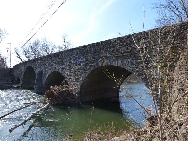
This bridge at first glance appears to be a stone arch that dates to 1775. The overall visual appearance of the bridge, combined with a plaque on the bridge which says the "original bridge" was built in 1775 and "restored" in 1937 seem to suggest this. However, the bridge is quite wide (30 foot roadway), and in the National Bridge Inventory is listed as a concrete arch built in 1825 and rehabilitated in 1937. After a closer examination of the NBI data and the bridge itself, it appears that in 1775 a bridge was first built at this location. In 1825, the bridge was replaced with a stone arch. In 1937, the stone arch was replaced with a concrete arch bridge. The concrete arch bridge was wider but kept the same arch shape as the stone arch bridge, and the stones from the 1825 bridge were placed on the spandrel walls of the bridge (and the parapets reused also), so that the concrete arch bridge looks like the stone arch bridge. Assuming this is all true, the 1825 bridge obviously does not have historic integrity. However, the 1937 alteration, apparently designed to try to retain some of the materials and character of the stone arch bridge, represents an early United States example of historic bridge preservation effort. This fact, combined with the portions of the 1825 bridge that remain on the bridge, mean that this bridge should be considered historic.
![]()
![]()
![]()
Coordinates (Latitude, Longitude):
Search For Additional Bridge Listings:
Bridgehunter.com: View listed bridges within 0.5 miles (0.8 kilometers) of this bridge.
Bridgehunter.com: View listed bridges within 10 miles (16 kilometers) of this bridge.
Additional Maps:
Google Streetview (If Available)
GeoHack (Additional Links and Coordinates)
Apple Maps (Via DuckDuckGo Search)
Apple Maps (Apple devices only)
Android: Open Location In Your Map or GPS App
Flickr Gallery (Find Nearby Photos)
Wikimedia Commons (Find Nearby Photos)
Directions Via Sygic For Android
Directions Via Sygic For iOS and Android Dolphin Browser
USGS National Map (United States Only)
Historical USGS Topo Maps (United States Only)
Historic Aerials (United States Only)
CalTopo Maps (United States Only)

© Copyright 2003-2024, HistoricBridges.org. All Rights Reserved. Disclaimer: HistoricBridges.org is a volunteer group of private citizens. HistoricBridges.org is NOT a government agency, does not represent or work with any governmental agencies, nor is it in any way associated with any government agency or any non-profit organization. While we strive for accuracy in our factual content, HistoricBridges.org offers no guarantee of accuracy. Information is provided "as is" without warranty of any kind, either expressed or implied. Information could include technical inaccuracies or errors of omission. Opinions and commentary are the opinions of the respective HistoricBridges.org member who made them and do not necessarily represent the views of anyone else, including any outside photographers whose images may appear on the page in which the commentary appears. HistoricBridges.org does not bear any responsibility for any consequences resulting from the use of this or any other HistoricBridges.org information. Owners and users of bridges have the responsibility of correctly following all applicable laws, rules, and regulations, regardless of any HistoricBridges.org information.
![]()