

View Information About HSR Ratings
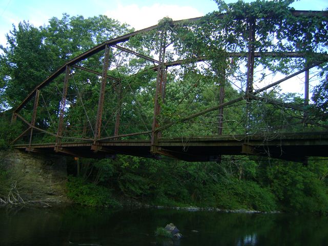
This bridge is among the shortest lenticular through truss bridges remaining. This does not diminish is significance however, since lenticular truss bridges are both exceedingly rare both in New York State and nationwide, yet also display one of the most unusual varieties of metal truss bridge ever built. Like all lenticular truss bridges in New York State, this bridge is the product of the Berlin Iron Bridge Company, originally known as the Corrugated Metal Company. This bridge was constructed in 1888. In 1903, on the east end of the bridge, the noteworthy and regionally prolific builder Groton Bridge Company added a riveted Warren pony truss span to the bridge. This span accommodated a spillway for the Perry Sawmill that was once located here. The spillway today, unused for many years, is essentially filled in, but the trusses remain in place.
The bridge's deck was replaced in 1976, and the bridge closed to vehicular traffic in the early 1990s. The bridge today carries only non-motorized traffic and snowmobiles. There has been local interest in restoring this highly significant historic bridge, however, as is often the case, finding funding to do so has proven difficult. The bridge today continues to stand, overgrown, and with abutment deterioration visible. Now would most certainly be an excellent time to restore this bridge for continued non-motorized and snowmobile use.
The bridge is listed on the National Register of Historic Places, as well as the state register.
![]()
![]()
![]()
This historic bridge has been demolished. This map is shown for reference purposes only.
Coordinates (Latitude, Longitude):
Search For Additional Bridge Listings:
Bridgehunter.com: View listed bridges within 0.5 miles (0.8 kilometers) of this bridge.
Bridgehunter.com: View listed bridges within 10 miles (16 kilometers) of this bridge.
Additional Maps:
Google Streetview (If Available)
GeoHack (Additional Links and Coordinates)
Apple Maps (Via DuckDuckGo Search)
Apple Maps (Apple devices only)
Android: Open Location In Your Map or GPS App
Flickr Gallery (Find Nearby Photos)
Wikimedia Commons (Find Nearby Photos)
Directions Via Sygic For Android
Directions Via Sygic For iOS and Android Dolphin Browser
USGS National Map (United States Only)
Historical USGS Topo Maps (United States Only)
Historic Aerials (United States Only)
CalTopo Maps (United States Only)

© Copyright 2003-2024, HistoricBridges.org. All Rights Reserved. Disclaimer: HistoricBridges.org is a volunteer group of private citizens. HistoricBridges.org is NOT a government agency, does not represent or work with any governmental agencies, nor is it in any way associated with any government agency or any non-profit organization. While we strive for accuracy in our factual content, HistoricBridges.org offers no guarantee of accuracy. Information is provided "as is" without warranty of any kind, either expressed or implied. Information could include technical inaccuracies or errors of omission. Opinions and commentary are the opinions of the respective HistoricBridges.org member who made them and do not necessarily represent the views of anyone else, including any outside photographers whose images may appear on the page in which the commentary appears. HistoricBridges.org does not bear any responsibility for any consequences resulting from the use of this or any other HistoricBridges.org information. Owners and users of bridges have the responsibility of correctly following all applicable laws, rules, and regulations, regardless of any HistoricBridges.org information.
![]()