

View Information About HSR Ratings
This bridge's song is:

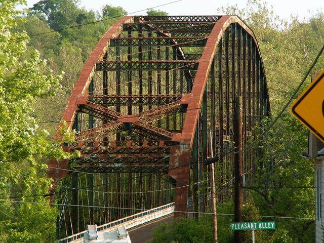
This mighty feat of engineering provides a long, single, simple span across the Great Miami River. The result of such a large span is that the bridge is awe-inspiring, with such high trusses, and a Parker truss configuration with a very complex overhead bracing system, resulting in a bridge that has unparalleled aesthetic qualities without need for superficial ornamentation. Although not the oldest truss bridge, with a 1914 construction date it was, like the Quebec Bridge (the largest cantilever span in the world, built in the 1910s) significant because of its size and beauty. To get a sense of the size of this bridge, look at the photo to the right. To the left of the photo, you can see the portal bracing for the bridge, large enough to allow two lane traffic to pass under it. Seeing the small size of the portal in that photo, you can see how tall the bridge is, as well as how long.
This bridge is apparently known locally as the "Singing Bridge," possibly named such due to the wooden deck originally on the bridge. The metal grating deck added in 1984 probably only furthered this nickname's cause. It certainly is an elegant name for an elegant bridge. Unfortunately, the Singing Bridge has been silenced forever. This bridge was reduced to rubble and scrap metal, nearly a quarter mile from its completed replacement slab bridge.

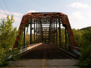
This is a through truss bridge with pinned connections, featuring a Parker truss configuration. It is a large single span bridge, with 17 panels composing the 460 foot span that this bridge produces. The bridge features built-up beams with extensive v-lacing and lattice, and includes unusual box members that feature v-lacing or lattice on all four sides. The height of the bridge's trusses is 71 feet. A bridge that has trusses of that height must feature extensive sway bracing, and indeed this bridge is no exception. Some of the sway bracing lines up with the unusual horizontal members on the truss, forming a box-like shape overhead on the bridge. The railing on the bridge is modified, although the west side of the bridge has not had the double set of Armco railings added, and original lattice railings remain, albeit with a piece of steel welded above it. Hamilton County engineered the structure, in response to a flood that wiped out the bridge preceding the truss bridge. The superstructure of the bridge was built in 1914 by the Brackett Construction Company. The Van Camp Brothers constructed the ashlar (stone) abutments (later covered in concrete in 1983) and did the approach work. The bridge was built in about a year, with the contract for the bridge having been awarded only a year before completion. Regarding the contract and bids for the superstructure, only one other company had submitted a bid on building the bridge - the Massillon Bridge Company, which had been a prolific company in the pre-twentieth century years of metal truss bridge building. The local Brackett Construction Company won however, with the $2000 lower bid of $56,990. The bridge was originally built with a wooden deck, which was replaced with another wooden deck in 1947. A 1983 renovation replaced the deck with the metal grate deck seen in the photos. By 1996, the county was seeking replacement of the bridge and to mitigate adverse effect, Historic American Engineering Record documentation took place in August of that year. In 2001, the bridge was closed to traffic, after the completion of the new bridge nearly a quarter mile east of the truss bridge. The new alignment of the modern bridge turned Blue Rock Road into a smooth bypass around New Baltimore. The truss bridge however continued to serve local New Baltimore pedestrians (whether the county wanted this or not) who used it to access the park on the south side of the bridge. By 2006, the bridge retained only small amount of apparently white paint, and rust had mostly taken over the bridge. The rust had not yet damaged the bridge much however. By this time, the plaque on the bridge had been removed.
The bridge retained excellent historic integrity, however there were some alterations. The railings were partially replaced, as discussed previously. Also, some portions of the diagonals have been replaced, welded, or spliced. Lateral bracing under the deck had also been replaced. The wooden deck had been replaced with a metal grate deck. Otherwise, the bridge exhibited good historic integrity. The Ohio State Historic Preservation Office had noted that the bridge was eligible for the National Register of Historic Places. The bridge is significant as an example of an uncommon bridge type, the pin connected Parker truss. It is also a very large example of the structure type.
Way back in May, 2006, this bridge set a record on HistoricBridges.org for largest photo gallery. While it no longer comes anywhere near close to that record today, having been surpassed by other bridge documentations, HistoricBridges.org remains proud to offer a comprehensive collection of overview and detail photos of this historic bridge. HistoricBridges.org would have been equally proud to offer an additional narrative on this page detailing a wonderful decision to leave this bridge standing thanks to the wisdom and foresight of Hamilton County. Unfortunately, Hamilton County turned away from such a scenario. Instead, HistoricBridges.org is compelled to offer the below documentation as a permanent record of the failure to preserve this historic bridge.
On the fateful day of October 11, 2006, the day this bridge was destroyed, it seemed like that weekend even Mother Nature herself wanted to unleash her fury upon man and his wasteful, shortsighted ways, for as this bridge fell, one of the coldest and most powerful cold fronts ever seen so early in October roared through the Great Lakes area and made its way down into and beyond the Ohio River valley. By the end of the day, the very air in Hamilton County was almost as cold as the hearts of the officials that decided to destroy this bridge 1/4 mile away from its replacement. A bridge that connected a community to a park, and was not in the way of its replacement, this bridge deserved to be left standing for pedestrian use, or even better, fully restored for pedestrian use.
One cannot help but feel for the citizens of the unincorporated community of New Baltimore. During the field visit to this bridge, one of the residents briefly spoke with us. He had been a steelworker, and had great respect for the mammoth bridge that had been a landmark for a tiny community since 1914, and was not happy to know the bridge was coming down. Hamilton County's commissioners however apparently had no concern for such a small community in the county.
Some time ago, a county meeting took place which finalized the authorization of the demolition of the bridge, which was supported by the county engineer as well as the county commissions who approved the resolution agreeing with the assessment "...that the public convenience and welfare require the demolition of the Blue Rock Road Bridge." It is unclear how removing a crossing that was still being used by pedestrians increased convenience, nor how the loss of a beautiful landmark that brought a sense of identity to the small community of New Baltimore benefited the public welfare. The only convenience it offered was to the officials of Hamilton County who no longer have to worry about improving the quality of their county through preservation of a beautiful historic landmark.
One might ask if it is selfish to condemn Hamilton County when they have preserved bridges like Blome Road and have also restored an extremely rare bowstring truss bridge. These acts of preservation are appreciated, and HistoricBridges.org hopes more efforts will follow. At the same time, these acts of preservation do not absolve the demolition of the Blue Rock Road Bridge, especially when the demolition was so pointless, and the bridge so rare and significant. Preserving a bowstring is as essential as preserving a bridge like Blue Rock Road Bridge but at the same time, a bowstring is quite different from the Blue Rock Road Bridge, and so one bridge does not help to interpret the beauty and history of the other. They both must be preserved! Is the idea of preserving multiple bridges in one county unrealistic? Surely not, since a number of counties have preserved over a dozen wooden covered bridges. Are metal truss bridges, which often have greater integrity of materials and design, less worthy of such preservation? Absolutely not! There is more to the story of the Blue Rock Road Bridge. The Great Miami in Hamilton County was once home to a number of unusually long-spanning simple span truss bridges, and the Blue Rock Road Bridge was the last of these. As such, it is more than Hamilton County failing to preserve one large truss bridge. They had several large truss bridges and did not preserve a single one! Also, keep in mind that the Blue Rock Road Bridge was a quarter mile away from its replacement bridge, and was not in the way of anything.
The cost of wiping this bridge off the face of the earth was $200,000. Granted, this is pocket change to the government today, it still begs the question whether is is a wise use of money. This money could have gone toward restoring the truss bridge for pedestrian traffic, where it could become the centerpiece to the park it is next to, and also provide New Baltimore with easy access to the park. Whether you have a care for historic bridges or not, you should at least care about how the government spends your hard-earned money.
In closing comment, a tribute to the historic bridge's builders. The new, ugly bridge which is little more than a slab of concrete over water that serves is five spans. The historic Blue Rock Road Bridge was a single span structure. Have we really moved forward in technology and skill in the 21st Century? It took 21st century builders four piers to do what early 20th century builders did with only abutments! Also, not to downplay their jobs, but the people today who work on bridges today, as well as the people who work in the steel mills today, as admirable and important as their jobs are, face none of the pain, suffering, low wages, and lack of safety that the people who made the Blue Rock Road Bridge a reality. These workers and craftsmen sacrificed so much to help unite this country's roads, and in one day... indeed a few seconds... a priceless memorial to these people was erased by wasteful and short-sighted decision that has done future generations a great disservice.
![]()

![]()

![]()
![]()
![]()

![]()
This historic bridge has been demolished. This map is shown for reference purposes only.
Coordinates (Latitude, Longitude):
Search For Additional Bridge Listings:
Bridgehunter.com: View listed bridges within 0.5 miles (0.8 kilometers) of this bridge.
Bridgehunter.com: View listed bridges within 10 miles (16 kilometers) of this bridge.
Additional Maps:
Google Streetview (If Available)
GeoHack (Additional Links and Coordinates)
Apple Maps (Via DuckDuckGo Search)
Apple Maps (Apple devices only)
Android: Open Location In Your Map or GPS App
Flickr Gallery (Find Nearby Photos)
Wikimedia Commons (Find Nearby Photos)
Directions Via Sygic For Android
Directions Via Sygic For iOS and Android Dolphin Browser
USGS National Map (United States Only)
Historical USGS Topo Maps (United States Only)
Historic Aerials (United States Only)
CalTopo Maps (United States Only)

© Copyright 2003-2024, HistoricBridges.org. All Rights Reserved. Disclaimer: HistoricBridges.org is a volunteer group of private citizens. HistoricBridges.org is NOT a government agency, does not represent or work with any governmental agencies, nor is it in any way associated with any government agency or any non-profit organization. While we strive for accuracy in our factual content, HistoricBridges.org offers no guarantee of accuracy. Information is provided "as is" without warranty of any kind, either expressed or implied. Information could include technical inaccuracies or errors of omission. Opinions and commentary are the opinions of the respective HistoricBridges.org member who made them and do not necessarily represent the views of anyone else, including any outside photographers whose images may appear on the page in which the commentary appears. HistoricBridges.org does not bear any responsibility for any consequences resulting from the use of this or any other HistoricBridges.org information. Owners and users of bridges have the responsibility of correctly following all applicable laws, rules, and regulations, regardless of any HistoricBridges.org information.
![]()