

View Information About HSR Ratings
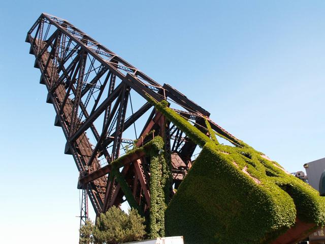
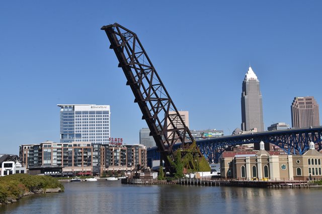
This bridge was fabricated by the King Bridge Company. The Scherzer Rolling Lift Bridge Company was the engineering company that designed the bridge. The Pittsburgh Construction Company erected the structure. This bridge was the longest Scherzer Rolling Lift when built, and thus is historically significant as a major engineering achievement when it was completed. In addition, the bridge is significant simply because it is a documented example of the patented design that the Scherzer Rolling Lift Bridge Company aggressively maintained its rights to. The bridge is also among the oldest of Cleveland's railroad bridges. Finally, the bridge's fabricator was a local company that had been one of the most important bridge companies that was nationally prolific in the late 1800s, the King Bridge Company, which was located in Cleveland. For all of these reasons, this bridge is a very significant structure. Fortunately, the city of Cleveland has recognized the importance of this structures in terms of beauty and history. Although no repair work has been done, this bridge has been allowed to stand in its open position for its heritage value, and it is also lit up at night to add to the aesthetic qualities of the bridge.


This bridge is tagged with the following special condition(s): Unorganized Photos
![]()
![]()
![]()
![]()
Coordinates (Latitude, Longitude):
Search For Additional Bridge Listings:
Bridgehunter.com: View listed bridges within 0.5 miles (0.8 kilometers) of this bridge.
Bridgehunter.com: View listed bridges within 10 miles (16 kilometers) of this bridge.
Additional Maps:
Google Streetview (If Available)
GeoHack (Additional Links and Coordinates)
Apple Maps (Via DuckDuckGo Search)
Apple Maps (Apple devices only)
Android: Open Location In Your Map or GPS App
Flickr Gallery (Find Nearby Photos)
Wikimedia Commons (Find Nearby Photos)
Directions Via Sygic For Android
Directions Via Sygic For iOS and Android Dolphin Browser
USGS National Map (United States Only)
Historical USGS Topo Maps (United States Only)
Historic Aerials (United States Only)
CalTopo Maps (United States Only)

© Copyright 2003-2024, HistoricBridges.org. All Rights Reserved. Disclaimer: HistoricBridges.org is a volunteer group of private citizens. HistoricBridges.org is NOT a government agency, does not represent or work with any governmental agencies, nor is it in any way associated with any government agency or any non-profit organization. While we strive for accuracy in our factual content, HistoricBridges.org offers no guarantee of accuracy. Information is provided "as is" without warranty of any kind, either expressed or implied. Information could include technical inaccuracies or errors of omission. Opinions and commentary are the opinions of the respective HistoricBridges.org member who made them and do not necessarily represent the views of anyone else, including any outside photographers whose images may appear on the page in which the commentary appears. HistoricBridges.org does not bear any responsibility for any consequences resulting from the use of this or any other HistoricBridges.org information. Owners and users of bridges have the responsibility of correctly following all applicable laws, rules, and regulations, regardless of any HistoricBridges.org information.
![]()