

View Information About HSR Ratings
2021 Update: This bridge remains in storage, however a new board of directors for the Preble County Historical Society is now looking for ways to get the bridge restored and reassembled.
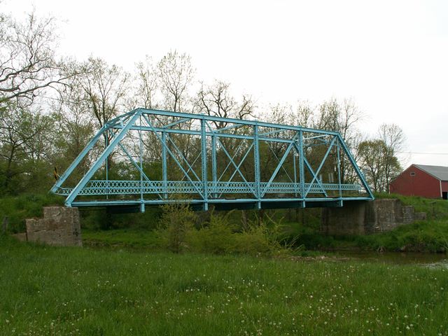
This bridge is a pin connected Pratt through truss with six panels. It sits on concrete abutments. The bridge retains original lattice railings. V-lacing is present under the top chord and on vertical members. The portal bracing is an a-frame design. The superstructure appears to be in good condition, and the bridge would certainly be an excellent candidate for restoration. The only major trouble spot is the deck which someone creatively patched with plate steel, braced with concrete reinforcing rods.
This bridge is up for replacement, so its future is uncertain and it will be listed on HistoricBridges.org as "at risk" for the time being. However, ODOT reported that the Preble County Historical Society is interested in relocating and preserving the bridge over Aukerman Creek on their property at 7693 Swartsel Road, Eaton, Ohio. HistoricBridges.org sincerely hopes this comes to pass, since this would be a fine preservation solution.
Information and Findings From Ohio's Historic Bridge InventorySetting/Context The single-span, 87-foot-long, Pratt, pin-connected, through truss, is one of 15 extant examples there were constructed after 1899 according to the Ohio Historic Bridge Inventory Database. There are currently 3 considered eligible for the National Register and one listed on the National Register within this subcategory of bridges from the same era. Physical Description The bridge retains most of its original integrity in design and materials, and features: rivet-connections, complete lattice railings, and has double eyebars at the bottom chords, as the end vertical members, and diagonals. Based on the portal bracing's design, it was thought to have been built by the Brookville Bridge Company. However, Preble County has Indiana Bridge Company plans that indicate that this and TR 445 were constructed by Indiana Bridge Company. Integrity The bridge retains most of its original integrity in design and materials, and features: rivet-connections, complete lattice railings, and has double eyebars at the bottom chords, as the end vertical members, and diagonals. Summary of Significance In 2008 the bridge superstructure was recorded as being replaced; "The 1907 truss is gone". However, based on the 2012 ODOT project package, the 1907 truss still there according to D-8 2/18/2011. Notes On replacement list. 2/18/ 2011 D-8 reports superstructure is in place. Scheduled for replacement, pending a reevaluation.). In 2008, our inventory notes stated that the bridge "superstructure was recently replaced" (R. Smith 3/08). Therefore, the bridge was placed into the Ohio Historic Bridge Inventory Database's "Morgue" file for replaced structures. Consequently, the bridge was not evaluated and not included in the Ohio DOT Historic Bridge Inventory Summary and Tables Survey Forms for Eligible/National Register Listed Bridges (December 2009), accepted on April 28,2010. Based on the bridge's updated status from replaced to Eligible, in accordance with Appendix C, Stipulation 1 of the Section 106 Programmatic Agreement executed on November 30, 2011 (Agreement No. 16734): "FHWA and ODOT will ensure that through ODOT's Project Development Process (PDP), all feasible and prudent alternatives to replacement of a historic bridge are explored in the project scoping phase of the undertaking. Rehabilitation is preferred until proven infeasible or not a prudent use of public funding. Rehabilitation for vehicular use must be thoroughly evaluated before other alternatives are considered. Rehabilitation alternatives must consider a one-way pair alternative that involves rehabilitating the existing bridge and constructing a new parallel bridge, when applicable. If rehabilitation is not feasible and prudent, then bypassing it with an agreement to maintain the bridge, or relocation for another use must also be considered. Please refer to AASHTO's Guidelines for Historic Bridge Rehabilitation and Replacement (2008) and ODOT's Ohio Historic Bridge Maintenance and Preservation Guidance (2010)." A letter of commitment from the Preble County Historical Society dated November 7, 2012, was received by ODOT to take ownership of the bridg3e and preserve it on the Society's property at 7693 Swartsel Road, Eaton Ohio, as funds become available. Justification It is our finding, in accordance with Stipulation 2(B)(3) and Appendix C, Stipulation 4 of the Section 106 Programmatic Agreement executed on November 30, 2011 (Agreement No. 16734), which states that FHWA, ODOT and SHPO agree that the historic status of a bridge may change based on significant new information, ); that the bridge is eligible for listing in the National Register of historic places under Criterion C as a surviving example of an early 20th century Pin connected truss bridge built in the state of Ohio with good association. The bridge is situated in a rural setting on a township route with very low traffic volume (<400 ADT). It has been closed to traffic for several years with at least one detour, less than a mile north on Four Mile Road. The less than 100-foot-span makes it a good candidate for relocation or reuse, elevating its preservation potential (TPB 9/11/2012). Bridge Considered Historic By Survey: Yes |
![]()
![]()
![]()
Coordinates (Latitude, Longitude):
Search For Additional Bridge Listings:
Bridgehunter.com: View listed bridges within 0.5 miles (0.8 kilometers) of this bridge.
Bridgehunter.com: View listed bridges within 10 miles (16 kilometers) of this bridge.
Additional Maps:
Google Streetview (If Available)
GeoHack (Additional Links and Coordinates)
Apple Maps (Via DuckDuckGo Search)
Apple Maps (Apple devices only)
Android: Open Location In Your Map or GPS App
Flickr Gallery (Find Nearby Photos)
Wikimedia Commons (Find Nearby Photos)
Directions Via Sygic For Android
Directions Via Sygic For iOS and Android Dolphin Browser
USGS National Map (United States Only)
Historical USGS Topo Maps (United States Only)
Historic Aerials (United States Only)
CalTopo Maps (United States Only)

© Copyright 2003-2024, HistoricBridges.org. All Rights Reserved. Disclaimer: HistoricBridges.org is a volunteer group of private citizens. HistoricBridges.org is NOT a government agency, does not represent or work with any governmental agencies, nor is it in any way associated with any government agency or any non-profit organization. While we strive for accuracy in our factual content, HistoricBridges.org offers no guarantee of accuracy. Information is provided "as is" without warranty of any kind, either expressed or implied. Information could include technical inaccuracies or errors of omission. Opinions and commentary are the opinions of the respective HistoricBridges.org member who made them and do not necessarily represent the views of anyone else, including any outside photographers whose images may appear on the page in which the commentary appears. HistoricBridges.org does not bear any responsibility for any consequences resulting from the use of this or any other HistoricBridges.org information. Owners and users of bridges have the responsibility of correctly following all applicable laws, rules, and regulations, regardless of any HistoricBridges.org information.
![]()