

View Information About HSR Ratings
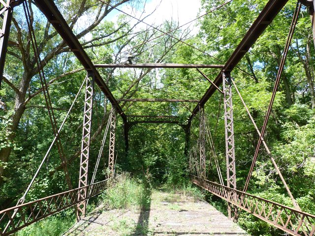
This bridge has been abandoned for a long time and is very overgrown. It is also severely deteriorated. Despite this, the bridge should be considered to have a substantial amount of historic significance (more than the Historic Bridge Inventory gives the bridge) because it has several unusual details. While they are missing at one end, the knee braces for the portal bracing have an ornate cutout design to them. Also, the struts have an unusual pediment design to them. These details are unusual. It is not known who built this bridge. It might be a rare example of a variant design built by a prolific bridge company, or it might be one of the last surviving examples of a less prolific bridge company. In either case, the bridge is noteworthy because of its unusual details. Despite the deterioration, enough remains of the bridge that it could be restored, perhaps as part of a project to relocate and reuse the bridge on a non-motorized trail. It should be noted that even though one portal is missing the decorative knee bracing, the surviving knee braces could serve as a template allowing replicas to be created for the other end.
Information and Findings From Ohio's Historic Bridge InventorySetting/Context The bridge is closed and overgrown. Physical Description The one span, 91'-long pin connected thru truss bridge has traditionally composed web members. It is clearly wrought iron, and the most unusual details are the X pattern of the portal brace webs and the shaped section used for the upper lateral bracing that is connected above the upper chords cover plate. One of the portals retains the original knee braces with punch decoration. Integrity Bridge is closed and there is significant impact damage to the trusses. The end panel floorbeam hanger detail has been altered (now welded). Summary of Significance County records do not record who fabricated or when the pin connected thru truss bridge with some early details was constructed. It is dated ca. 1888 based on its non-standard details. The truss bridge is not as well preserved as so many others in the county, and it has some alterations. It is not technologically significant in comparison with the deep and rich county assemblage of early and documented metal truss bridges. Pratt trusses were undoubtedly the most popular truss design of the last quarter of the 19th century and continued to be built into the 20th century. The design, which initially was a combination of wood compression and iron tension members, was patented in 1844 by Thomas & Caleb Pratt. The great advantage of the Pratt over other designs was the relative ease of calculating the distribution of stresses. More significantly, it translated well into an all-metal design in lengths of less than 200'. Prior to about 1890, a variety of panel point connections (including bolts, cast-iron pieces, and pins), end panel floorbeam connections, and lower chord designs were in widespread use. Many of the connection details were proprietary and associated with individual builders or companies, and thus earlier examples are generally taken to be technologically significant in showing the evolution of the design. Post-1890 Pratt trusses show a progression toward less variation in their details such that by 1895 the design was quite formulaic with few significant differences between the designs of various builders. This marked the end of the pin-connected Pratt's technological evolution and, in fact, it was soon eclipsed in the highway bridge market by more rigid, rivet-connected truss designs, particularly the Warren design, but also the Pratt design as well. The transition to riveted field connections, which happened even earlier with railroads than highways, was in no small part due to concerns about stress reversals at the pins under heavier loads and improvements in pneumatic field riveting equipment in the early 1900s. In Ohio, there are 185 Pratt trusses dating from ca. 1874 to 1945 with at least 60 dating prior to 1900 (Phase 1A, 2008). Bridge Considered Historic By Survey: No |
![]()
![]()
![]()
Coordinates (Latitude, Longitude):
Search For Additional Bridge Listings:
Bridgehunter.com: View listed bridges within 0.5 miles (0.8 kilometers) of this bridge.
Bridgehunter.com: View listed bridges within 10 miles (16 kilometers) of this bridge.
Additional Maps:
Google Streetview (If Available)
GeoHack (Additional Links and Coordinates)
Apple Maps (Via DuckDuckGo Search)
Apple Maps (Apple devices only)
Android: Open Location In Your Map or GPS App
Flickr Gallery (Find Nearby Photos)
Wikimedia Commons (Find Nearby Photos)
Directions Via Sygic For Android
Directions Via Sygic For iOS and Android Dolphin Browser
USGS National Map (United States Only)
Historical USGS Topo Maps (United States Only)
Historic Aerials (United States Only)
CalTopo Maps (United States Only)

© Copyright 2003-2024, HistoricBridges.org. All Rights Reserved. Disclaimer: HistoricBridges.org is a volunteer group of private citizens. HistoricBridges.org is NOT a government agency, does not represent or work with any governmental agencies, nor is it in any way associated with any government agency or any non-profit organization. While we strive for accuracy in our factual content, HistoricBridges.org offers no guarantee of accuracy. Information is provided "as is" without warranty of any kind, either expressed or implied. Information could include technical inaccuracies or errors of omission. Opinions and commentary are the opinions of the respective HistoricBridges.org member who made them and do not necessarily represent the views of anyone else, including any outside photographers whose images may appear on the page in which the commentary appears. HistoricBridges.org does not bear any responsibility for any consequences resulting from the use of this or any other HistoricBridges.org information. Owners and users of bridges have the responsibility of correctly following all applicable laws, rules, and regulations, regardless of any HistoricBridges.org information.
![]()