HistoricBridges.org Menu: HistoricBridges.org Menu:


We Recommend:
Bach Steel - Experts at historic truss bridge restoration.

HistoricBridges.org: Bridge Browser

Marion Williamsport Road Bridge

Marion Williamsport Road Bridge

Primary Photographer(s): Nathan Holth

Bridge Documented: August 11, 2012

View Photos
and Videos
View Maps
and Links

Facility Carried / Feature Intersected
Marion Williamsport Road (CR-61) Over Whetstone Creek
Location
Rural: Morrow County, Ohio: United States
Construction Date and Builder / Engineer
By Builder/Contractor: Unknown
Rehabilitation Date
2001
Main Span Length
71.0 Feet (21.6 Meters)
Structure Length
72.0 Feet (21.9 Meters)
Roadway Width
16 Feet (4.88 Meters)
Spans
1 Main Span(s)
Inventory Number
5930030

Historic Significance Rating (HSR)
View Information About HSR Ratings

Bridge Documentation

View Archived National Bridge Inventory Report - Has Additional Details and Evaluation

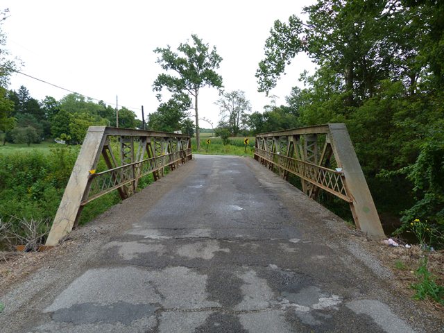
This bridge is an attractive example of a riveted Warren pony truss. The bridge retains good historic integrity above the deck level. However, much of the bottom chord has been replaced, either in entirety, or some of the battens have been replaced. The floor beams also have been replaced. Structurally, the bridge remains in fairly good condition.

Information and Findings From Ohio's Historic Bridge Inventory

Setting/Context

The bridge carries a 2 lane road over a stream in a rural area of active farms.

Physical Description

The 1 span, 72'-long, rivet-connected Warren pony truss bridge has verticals and is traditionally composed of built-up members. It has lattice railings.

Integrity

Rehabilitated in 2001.

Summary of Significance

The ca. 1920 Warren pony truss is a later example of its type/design with no distinguishing features. It has riveted connections, typical of Warren trusses from about 1900 to the 1940s when riveted connections began to be phased out in favor of welded connections. The survey has identified more than 150 pre-1961 riveted Warren pony truss bridges, making them a common truss type/design surviving in the state. This example is not historically significant for its technology or context. More distinguished examples better represent the significance of the type/design in the development of the state's road systems. The not eligible recommendation of the prior inventory remains appropriate.

Warren trusses are the most common design found in Ohio and the nation. The Ohio Phase 1A survey (2008) has identified more than 500 examples dating from 1897 to 1961, accounting for well over half of the approximately 800 pre-1961 metal trusses. The Warren design was particularly well suited to rigid (riveted, and later welded connections), but not as well suited to pin connections; this helps to explain its popularity in the 20th century rather than the 19th century, although it is based on a British patent issued to engineers James Warren and Willoughby Monzani in 1848. In the U.S., the popularity of the Warren truss coincided with improvements in pneumatic field riveting equipment starting about 1900. The Warren, which is based on a series of equilateral triangles, is identified by its simplicity of design, ease of construction with equal-sized members, and ability of some diagonals to act in both tensions and compression. Warren trusses are often stiffened by the addition of verticals; they can also have polygonal (sloped) upper chords to achieve greatest depth at midspan.

Warren trusses were a standard design of the Ohio State Highway Department in the 1910s and 1920s, but they achieved their greatest popularity with county engineers, who purchased the bridges from Ohio fabricators such as the Champion Bridge Co. and the Mt. Vernon Bridge Co. Fewer than 25 surviving rivet-connected Warren trusses date prior to 1915, and they represent the period when the rivet-connected design solidified its position as the most popular prefabricated county truss design.

Bridge Considered Historic By Survey: No

Divider

Photo Galleries and Videos: Marion Williamsport Road Bridge


View Photo Gallery

Bridge Photo-Documentation

Original / Full Size Photos
A collection of overview and detail photos. This gallery offers photos in the highest available resolution and file size in a touch-friendly popup viewer.
Alternatively, Browse Without Using Viewer

Divider

View Photo Gallery

Bridge Photo-Documentation

Mobile Optimized Photos
A collection of overview and detail photos. This gallery features data-friendly, fast-loading photos in a touch-friendly popup viewer.
Alternatively, Browse Without Using Viewer

Divider

View Video

Westbound Crossing

Full Motion Video
Streaming video of the bridge. Also includes a higher quality downloadable video for greater clarity or offline viewing.

Divider

View Video

Eastbound Crossing

Full Motion Video
Streaming video of the bridge. Also includes a higher quality downloadable video for greater clarity or offline viewing.

Divider

Maps and Links: Marion Williamsport Road Bridge

Coordinates (Latitude, Longitude):

Search For Additional Bridge Listings:

Bridgehunter.com: View listed bridges within 0.5 miles (0.8 kilometers) of this bridge.

Bridgehunter.com: View listed bridges within 10 miles (16 kilometers) of this bridge.

HistoricBridges.org Bridge Browser: View listed bridges within 0.5 miles (0.8 kilometers) of this bridge.

HistoricBridges.org Bridge Browser: View listed bridges within 10 miles (16 kilometers) of this bridge.

2021 National Bridge Inventory: View listed bridges within 0.5 miles (0.8 kilometers) of this bridge.

Additional Maps:

Google Maps

Google Streetview (If Available)

Bing Maps

OpenStreetMap

GeoHack (Additional Links and Coordinates)

Apple Maps (Via DuckDuckGo Search)

Apple Maps (Apple devices only)

MapQuest

HERE We Go Maps

ACME Mapper

Waze Map

Android: Open Location In Your Map or GPS App

Flickr Gallery (Find Nearby Photos)

Wikimedia Commons (Find Nearby Photos)

Directions Via Sygic For Android

Directions Via Sygic For iOS and Android Dolphin Browser

USGS National Map (United States Only)

Historical USGS Topo Maps (United States Only)

Historic Aerials (United States Only)

CalTopo Maps (United States Only)


Divider
 
Home Top

Divider

About - Contact

© Copyright 2003-2024, HistoricBridges.org. All Rights Reserved. Disclaimer: HistoricBridges.org is a volunteer group of private citizens. HistoricBridges.org is NOT a government agency, does not represent or work with any governmental agencies, nor is it in any way associated with any government agency or any non-profit organization. While we strive for accuracy in our factual content, HistoricBridges.org offers no guarantee of accuracy. Information is provided "as is" without warranty of any kind, either expressed or implied. Information could include technical inaccuracies or errors of omission. Opinions and commentary are the opinions of the respective HistoricBridges.org member who made them and do not necessarily represent the views of anyone else, including any outside photographers whose images may appear on the page in which the commentary appears. HistoricBridges.org does not bear any responsibility for any consequences resulting from the use of this or any other HistoricBridges.org information. Owners and users of bridges have the responsibility of correctly following all applicable laws, rules, and regulations, regardless of any HistoricBridges.org information.

Admin Login

Divider