

View Information About HSR Ratings
This bridge's song is:
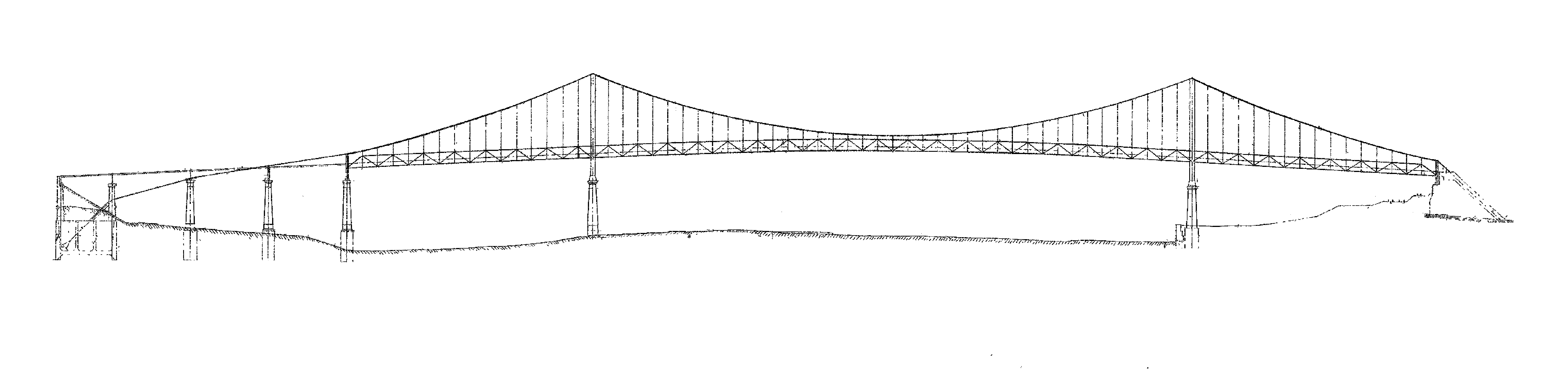
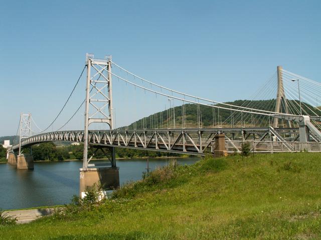
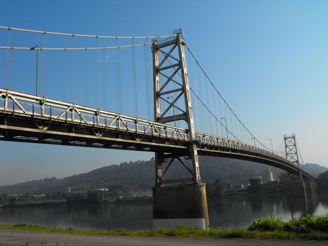
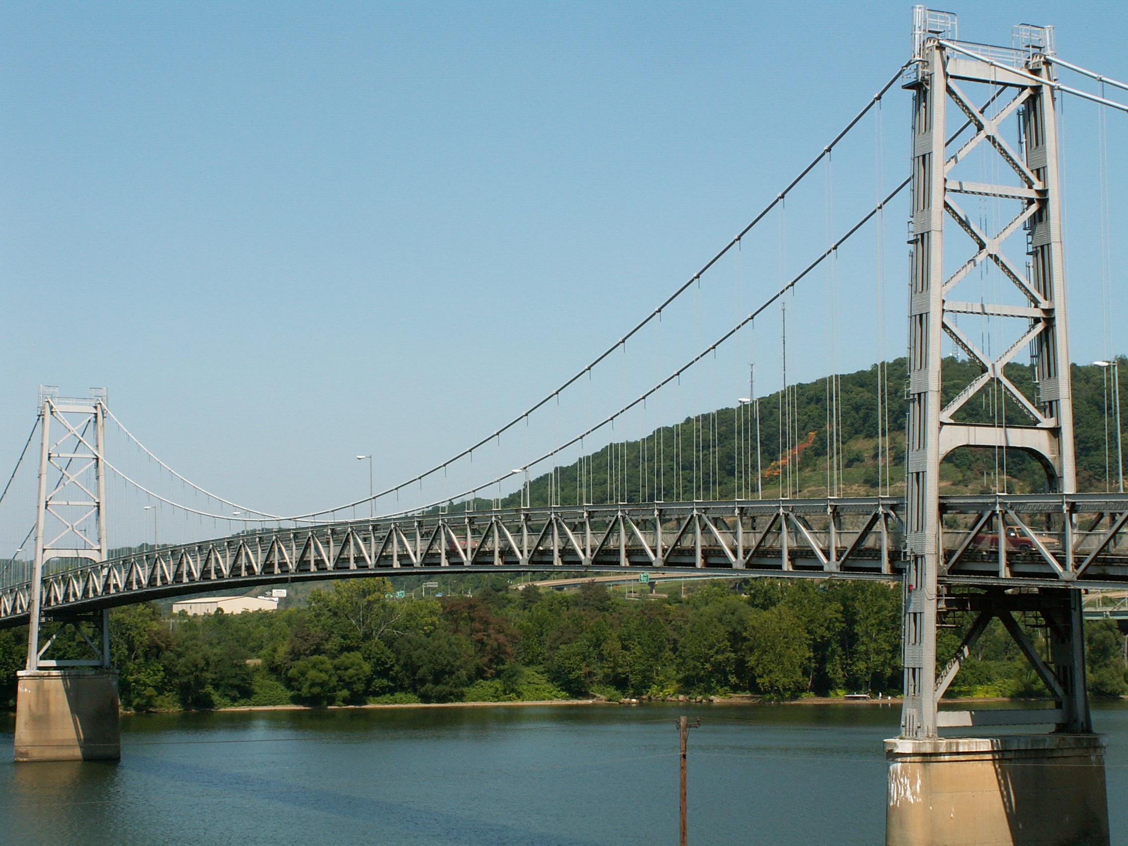
This beautiful wonder of engineering is a classic 1920s wire-cable suspension bridge. The total suspended length is 1251.75 Feet (381.5 Meters), the center suspension span length is 688.75 Feet (210 Meters), and the approach suspension span length consists of two spans at 283 Feet (86.26 Meters) each. Navigational vertical underclearance is 86 Feet (26.2 Meters) and the vertical underclearance at the railroad line is 20.3 Feet (6.2 Meters).
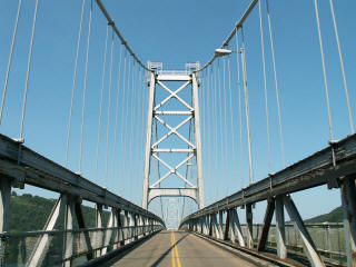
The bridge features a lattice design for the tower structure. Speaking of which, lattice can also be found, along with v-lacing in some areas of on the bridge, although no members of the stiffening truss have either. The top chords of the trusses have v-lacing however, and the towers have lattice. The bottoms of the towers have an attractive arch to them. Both Carnegie and Jones and Laughlin brands can be found on the various steel parts of the bridge. Compared to the fairly nearby Market Street Bridge, the towers on this bridge feel very tall and impressive. Some of this is due to the fairly narrow roadway width, which gives the illusion that the towers are taller. The bridge retains good overall historic integrity for a bridge of this size, although i-beams have been added that run parallel to the top chord of the stiffening truss. Other modifications include replacement of connection rivets with bolts.
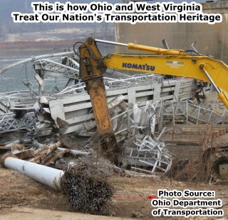
"When ODOT's not out plowing snow or repairing the roads we also enjoy blowing up old bridges." -Quote from Ohio Department of Transportation describing the official video of the demolition.
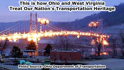
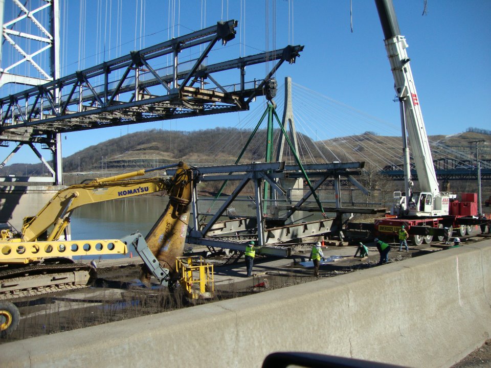
According to the above statement from the Department, the Ohio Department of Transportation takes pleasure in irreversibly destroying extremely rare historic bridges. Its hard to argue with their statement, given the number of historic bridges that Ohio has demolished in recent years. States like Ohio and Pennsylvania make the number of historic bridges destroyed in World War II in Europe seem modest. Indeed, ODOT and the hired demolition contractor carried out the complete destruction of this landmark far more efficiently and effectively than any wartime bomb could have, evidence of how much experience demolition contractors have the opportunity to gain, thanks to highway agencies like ODOT. When the Fort Steuben Bridge was built, engineers and contractors of the time could not have imagined how the demolition of a bridge like this could be brought down to a science that would destroy what they spent years designing and building in a matter of seconds. It is unfortunate that the Department might not instead take pleasure in preserving beautiful historic landmarks that would enhance the quality of life in Ohio.
Despite its obvious historic and aesthetic value, and potential for reuse as a non-motorized crossing, this historic bridge was demolished. The DOTs who owned this bridge said that every year the structure continued to deteriorate, and so the weight limit had to keep being lowered. Perhaps this was instead an indication that the DOTs are failing, not the bridge. Perhaps if the bridge had been properly maintained it would not be falling apart. Although it is the same age, Michigan and Ontario's Ambassador Bridge continues to serve traffic as the busiest North American international crossing with a major user being heavy fully-loaded semi trucks! Even at the time of demolition, the Fort Steuben Bridge could have and should have been restored. But instead, WVDOT and ODOT insisted on wasting $2.3 Million to demolish this bridge. Millions of valuable taxpayer dollars that could be used for anything from preserving this historic bridge to simply making area highways smoother and safer are instead being used to destroy this bridge just for the sake of wiping it off the face of the earth. They should instead focus funding into restoring this historic landmark and allowing it to continue to beatify Steubenville, Weirton, and the Ohio River. Such a graceful structure as a suspension bridge deserves to be left standing. Even people who are not generally "bridge enthusiasts" will often stop and photo a suspension bridge, because they are so large and impressive. To demolish a bridge such as this one is an atrocity to be sure. Both Ohio and West Virginia should be ashamed of themselves, not only for failing to maintain this bridge in the past, but also for not choosing to restore the bridge and make up for their past errors. Particular blame for this wasteful decision must be laid at ODOT's feet, since they acted as lead agency for the project. The demolition of the Fort Steuben Bridge is ridiculous.
Think of all the material waste that demolition causes. The steel of the bridge, which could have been left in place, restored, and reused for a pedestrian crossing, are instead turned into scrap metal. This means that fuel and resources must be used to ship the steel to a scrap yard (possibly as far as China) where extensive energy must be expended to melt down and reuse the steel. Other materials on the bridge must also be shipped away and disposed of. Sure, historic bridge demolitions bring some jobs and profit to demolition contractors. But perhaps if more historic bridges were preserved, these contractors could retool their people and equipment to engage in the good work of preservation.
One of the piers of the historic bridge was left standing. This pier will support a bridge structure that is to be constructed at the cost of a quarter million dollars to provide what is described as a lookout. Seriously?! The beautiful landmark has been destroyed! What is there left to look at? Additionally, why were the stiffening trusses of the historic bridge not saved and reused for this purpose? At least this would have saved a part of the historic bridge superstructure. A portion of the Rock Island Bridge in Minnesota was saved and reused in this manner. Instead, materials have been wasted and a new structure is to be used for this purpose. Even better, why could the entire bridge not have been the outlook? If the entire bridge had been left standing, both citizens of Weirton and Steubenville could have enjoyed the facility. Instead, officials opted for a solution that leaves the citizens of Weirton short-changed.
The bridge may be gone, but HistoricBridges.org remains. HistoricBridges.org makes it a goal to encourage the preservation of historic bridges. When a historic bridge is demolished, HistoricBridges.org work continues by maintaining a page like this designed not only to document the appearance and design of the historic bridge, but to record the circumstances surrounding the demolition of the historic bridge.
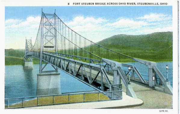
Above: Historical postcard of bridge.


![]()
![]()
![]()
![]()

![]()

![]()
![]()

![]()
This historic bridge has been demolished. This map is shown for reference purposes only.
Coordinates (Latitude, Longitude):
Search For Additional Bridge Listings:
Bridgehunter.com: View listed bridges within 0.5 miles (0.8 kilometers) of this bridge.
Bridgehunter.com: View listed bridges within 10 miles (16 kilometers) of this bridge.
Additional Maps:
Google Streetview (If Available)
GeoHack (Additional Links and Coordinates)
Apple Maps (Via DuckDuckGo Search)
Apple Maps (Apple devices only)
Android: Open Location In Your Map or GPS App
Flickr Gallery (Find Nearby Photos)
Wikimedia Commons (Find Nearby Photos)
Directions Via Sygic For Android
Directions Via Sygic For iOS and Android Dolphin Browser
USGS National Map (United States Only)
Historical USGS Topo Maps (United States Only)
Historic Aerials (United States Only)
CalTopo Maps (United States Only)

© Copyright 2003-2024, HistoricBridges.org. All Rights Reserved. Disclaimer: HistoricBridges.org is a volunteer group of private citizens. HistoricBridges.org is NOT a government agency, does not represent or work with any governmental agencies, nor is it in any way associated with any government agency or any non-profit organization. While we strive for accuracy in our factual content, HistoricBridges.org offers no guarantee of accuracy. Information is provided "as is" without warranty of any kind, either expressed or implied. Information could include technical inaccuracies or errors of omission. Opinions and commentary are the opinions of the respective HistoricBridges.org member who made them and do not necessarily represent the views of anyone else, including any outside photographers whose images may appear on the page in which the commentary appears. HistoricBridges.org does not bear any responsibility for any consequences resulting from the use of this or any other HistoricBridges.org information. Owners and users of bridges have the responsibility of correctly following all applicable laws, rules, and regulations, regardless of any HistoricBridges.org information.
![]()