

View Information About HSR Ratings
HistoricBridges.org has a policy to not include wooden covered bridges in the Bridge Browser. There are two reasons for this. First, covered bridges are extensively documented elsewhere, so doing so here is a waste of everyone's time. Second, it is an attempt to counter the unfair bias in North America where nearly every historic wooden covered bridge is preserved, while for all other historic bridge structure types, neglect and/or demolition is by far the most common fate. This is particularly true for historic metal truss bridges. This policy presented a bit of a challenge with this bridge, since in 1913, one of this bridge's two covered bridge spans dating to 1868 was destroyed in a flood and replaced with a beautiful rivet-connected through truss. Therefore, this webpage is intended to provide photographs and information for the metal truss span only. The only place the covered bridge span makes a full appearance is in the videos for the bridge, so if you are curious to see the covered bridge span, please view the videos.
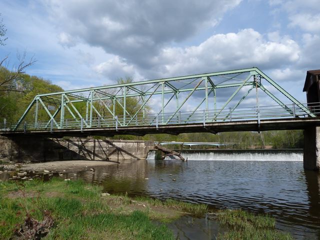
This metal truss span is among the earlier rivet-connected through truss bridges in Ohio. It is also visually noted for its use of v-lacing instead of cover plate on the top chord and end post, which gives the bridge a more attractive, lightweight appearance. The truss span on the Harpersfield Bridge is similar to the truss span on the Callender Road Bridge. Note the portal bracing design and the unusual feature of v-lacing on both the top and bottom sides of the top chord/end post. The span on Harpersfield was attributed to the Riverside Bridge Company, but it was also built in 1913, the same year as the Callender Road Bridge, in response to a flood that damaged these bridges. However, the Massillon Bridge Company was who reportedly built the Callender Road Bridge. The similarities between the bridges could indicate the county had some input on the design of the bridges despite having different builders construct them. If so, this would represent the trend that was occurring at this time to have the highway agency direct bridge companies to build bridges to the agency's design, not the company's own design.
Interestingly, when this bridge was first listed in the National Register of Historic Places, the truss span was not included as part of the listed property. It is this sort of unfair treatment in favor of covered bridges and against metal truss bridges which prompts HistoricBridges.org's exclusion of covered bridges. Fortunately for the metal truss however, National Register regulations stipulate that the entire structure must be included when a bridge is listed, so the metal truss is today officially a National Register Listed span alongside the covered span.
Information and Findings From Ohio's Historic Bridge InventorySetting/Context The bridge carries a 1 lane road over a stream in a sparsely developed, rural setting. The bridge is the southernmost span in the Harpersfield Covered Bridge (0432482), which was built in 1868. The truss was added to lengthen the bridge after the 1913 flood cut a new channel. Physical Description The 1 span, 139'-long, rivet-connected Pratt thru truss is composed of built-up members and has pipe railings. A cantilevered sidewalk has been added to one side. Integrity Has integrity. Summary of Significance The 1868 Harpersfield Covered Bridge is NR-listed (1975) but the steel truss span at its southern end was not included as part of the listed property. It was non-select in the prior inventory. By NR definitions, since it is part of the same structure/crossing, it is part of the structure and thus eligible even though it has a separate SFN and was built as a separate episode in the crossing's history following the 1913 flood. As well, it now ranks among the oldest surviving rivet-connected Pratt thru truss bridges in the state. It is one of four riveted Pratt thru truss bridges built as replacement structures lost during the flood. Pratt trusses were undoubtedly the most popular truss design of the last quarter of the 19th century and continued to be built into the 20th century, although eventually superseded in popularity by Warren trusses. The design, which initially was a combination of wood compression and iron tension members, was patented in 1844 by Thomas & Caleb Pratt. Ohio has three covered bridges that use this combination configuration, but they are all modern reconstructions based on the Pratt patent. The great advantage of the Pratt over other designs was the relative ease of calculating the distribution of stresses. More significantly, it translated well into an all-metal design in lengths of less than 200'. Significant surviving examples of all-metal Pratt trusses mostly date to the last quarter of the 19th century, and they are found with thru, pony, and the less common bedstead configuration. Prior to about 1890, a variety of panel point connections were in widespread use (including bolts, cast-iron pieces, and pins), but engineering opinion was coalescing around pins as the most efficient and constructible. Many of the connection details were proprietary and associated with individual builders or companies, and thus earlier examples are generally taken to be technologically significant in showing the evolution of the design. Later post-1890 Pratt trusses show a progression toward less variation in their details such that by 1900 the design was quite formulaic with few significant differences between the designs of various builders. This marked the end of the pin-connected Pratt's technological evolution and, in fact, it was soon waning and eclipsed in the highway bridge market by more rigid, rivet-connected truss designs, particularly the Warren but also riveted Pratts. The transition to riveted connections, which happened even earlier with railroads than highways, was in no small part due to concerns about stress reversals at the pins under heavier loads and improvements in pneumatic field riveting equipment in the early 1900s. In Ohio, Pratt truss highway bridges, whether pinned or riveted, were almost always built under the auspices of counties and local units of government; the Pratt was not a standard design of the state highway department. In Ohio, there are 185 Pratt trusses dating from ca. 1874 to 1945 with at least 60 dating prior to 1900 (Phase 1A, 2008). The technologically significant unaltered examples of pin-connected Pratt trusses for the most part date prior to 1900 and have documented or attributed builders and dates of construction and/or significant connection or member details. Later post-1900 examples are less technologically significant. Significant unaltered examples of riveted-connected Pratt trusses date from ca. 1900 to 1915. Justification The bridge is one of over 40 extant riveted thru truss bridges of all designs built between 1904 and 1959. This example is representative of the population and has moderate significance. There are also many riveted thru truss bridges servicing the many rail lines in the state. Bridge Considered Historic By Survey: Yes |
![]()
![]()
![]()

![]()
![]()
Coordinates (Latitude, Longitude):
Search For Additional Bridge Listings:
Bridgehunter.com: View listed bridges within 0.5 miles (0.8 kilometers) of this bridge.
Bridgehunter.com: View listed bridges within 10 miles (16 kilometers) of this bridge.
Additional Maps:
Google Streetview (If Available)
GeoHack (Additional Links and Coordinates)
Apple Maps (Via DuckDuckGo Search)
Apple Maps (Apple devices only)
Android: Open Location In Your Map or GPS App
Flickr Gallery (Find Nearby Photos)
Wikimedia Commons (Find Nearby Photos)
Directions Via Sygic For Android
Directions Via Sygic For iOS and Android Dolphin Browser
USGS National Map (United States Only)
Historical USGS Topo Maps (United States Only)
Historic Aerials (United States Only)
CalTopo Maps (United States Only)

© Copyright 2003-2024, HistoricBridges.org. All Rights Reserved. Disclaimer: HistoricBridges.org is a volunteer group of private citizens. HistoricBridges.org is NOT a government agency, does not represent or work with any governmental agencies, nor is it in any way associated with any government agency or any non-profit organization. While we strive for accuracy in our factual content, HistoricBridges.org offers no guarantee of accuracy. Information is provided "as is" without warranty of any kind, either expressed or implied. Information could include technical inaccuracies or errors of omission. Opinions and commentary are the opinions of the respective HistoricBridges.org member who made them and do not necessarily represent the views of anyone else, including any outside photographers whose images may appear on the page in which the commentary appears. HistoricBridges.org does not bear any responsibility for any consequences resulting from the use of this or any other HistoricBridges.org information. Owners and users of bridges have the responsibility of correctly following all applicable laws, rules, and regulations, regardless of any HistoricBridges.org information.
![]()