

View Information About HSR Ratings

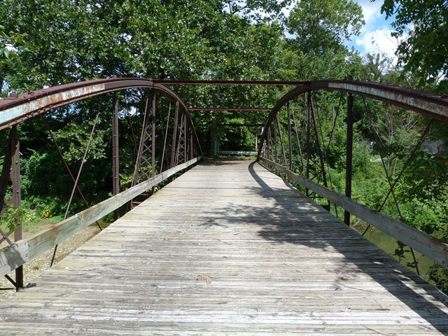
This bridge is sometimes called The Trestle Bridge because there was once a railroad bridge that crossed the creek beside this bridge. The bowstring truss bridge is arguably the rarest "once-common" type of bridge in North America. A blend of truss and arch structure types, these bridges were mainly built in the 1870s, and bridge builders experimented with the use of metal in bridge building. As such, with the exception of a few outliers, bowstring truss bridges are among the oldest metal bridges in the country. This rarity does not mean however that appropriate sources of funding are available to restore the few remaining bridges however. Programs like the National Historic Covered Bridge Preservation Act have saved only one structure type, leaving other structure types, regardless of historic significance, to be unfunded and often demolished and replaced.
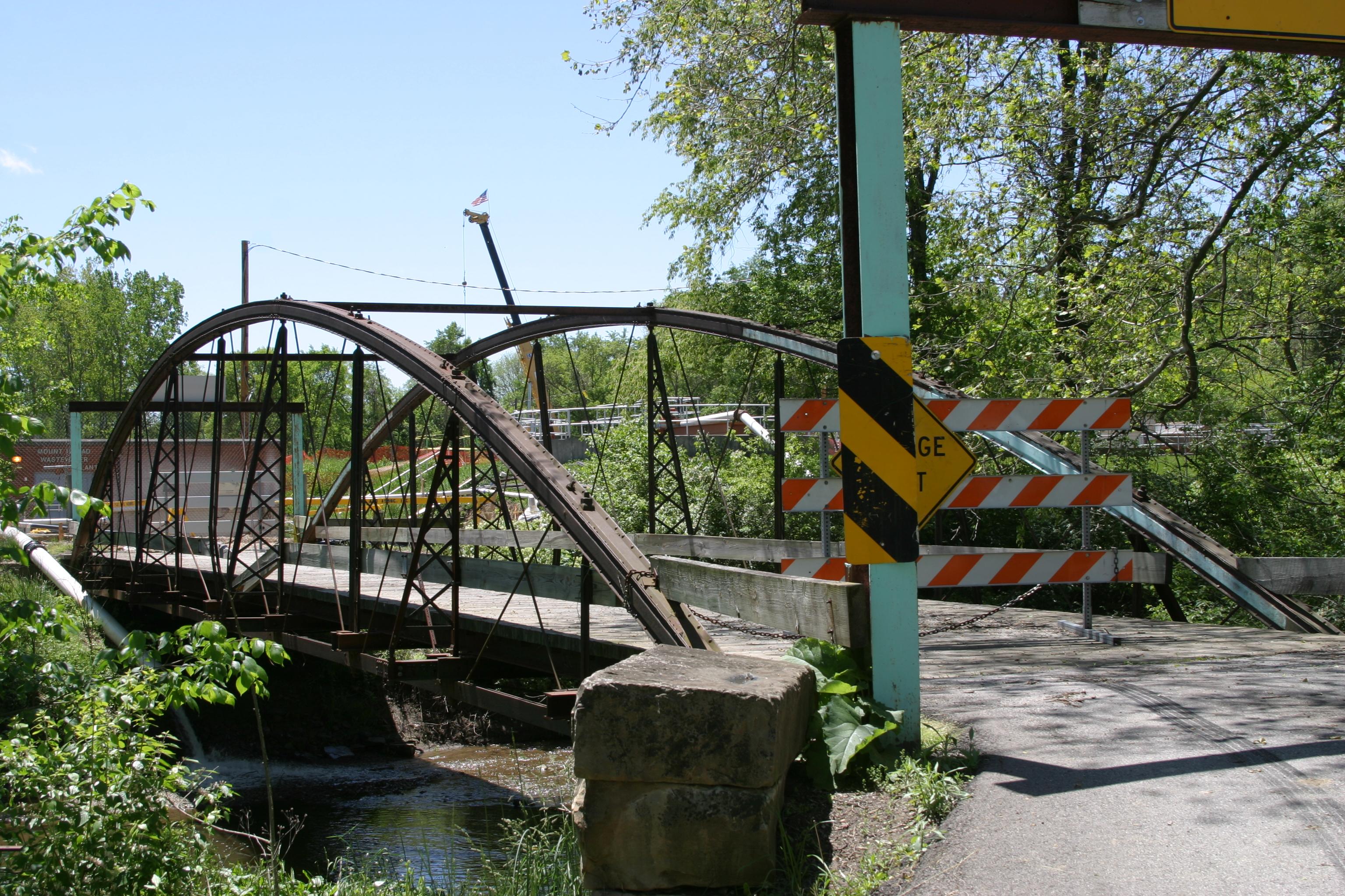
The fate of the Loren Road Bridge is in question, because it was at the receiving end of a careless driver who collided with and damaged the bridge. Vehicle-bridge collisions occur far too often, most likely because drivers are never penalized appropriately. In this case, the driver's insurance should have been called upon to repair the damages done to this important historic bridge. Drivers need to remember to reduce speed significantly when crossing narrow and historic bridges. Doing so will ensure that control of the vehicle is not lost, and that both bridge and driver remain safe.
The Loren Road Bridge is a rare example of a Wrought Iron bridge Company bowstring truss bridge. Alterations include replacement of much of the flooring system, as well as replacement of the sway bracing. Otherwise, the structure is an excellent example of its type, and is a fairly long example as well.
Information and Findings From Ohio's Historic Bridge InventorySetting/Context The bridge is closed to all traffic due to impact damage from 2005. It is located on a road adjacent to the county yard, fairgrounds, and sewage treatment plant. The road is closed. Physical Description The 1 span, 104'-long, wrought-iron bowstring thru truss bridge has tubular upper chord, built-up verticals, rod diagonals, and lower chord bars. The bridge was strengthened by adding members prior to its closing. Integrity Rehabilitated in 1999. Impact damage caused closure in 2005. Summary of Significance The 1879 bowstring truss is a rare and technologically significant example of a WIBCo patented bowstring truss. The bridge was sensitively rehabilitated in 1999 and has had some impact damage forcing its closure. The eligible recommendation of the prior inventory remains appropriate. It has been documented by HAER OH-59. Justification The bridge is one of the 22 extant bowstring truss bridges that survive in the state. Having so many is remarkable, and even though they are "common" based on their numbers, each is an important and irreplaceable record of the development of the metal truss bridge and the ingenuity associated with the Ohio industrial development. The bridge has high significance. Bridge Considered Historic By Survey: Yes |
This bridge is tagged with the following special condition(s): Keystone Columns
![]()
![]()
![]()
![]()
Coordinates (Latitude, Longitude):
Search For Additional Bridge Listings:
Bridgehunter.com: View listed bridges within 0.5 miles (0.8 kilometers) of this bridge.
Bridgehunter.com: View listed bridges within 10 miles (16 kilometers) of this bridge.
Additional Maps:
Google Streetview (If Available)
GeoHack (Additional Links and Coordinates)
Apple Maps (Via DuckDuckGo Search)
Apple Maps (Apple devices only)
Android: Open Location In Your Map or GPS App
Flickr Gallery (Find Nearby Photos)
Wikimedia Commons (Find Nearby Photos)
Directions Via Sygic For Android
Directions Via Sygic For iOS and Android Dolphin Browser
USGS National Map (United States Only)
Historical USGS Topo Maps (United States Only)
Historic Aerials (United States Only)
CalTopo Maps (United States Only)

© Copyright 2003-2024, HistoricBridges.org. All Rights Reserved. Disclaimer: HistoricBridges.org is a volunteer group of private citizens. HistoricBridges.org is NOT a government agency, does not represent or work with any governmental agencies, nor is it in any way associated with any government agency or any non-profit organization. While we strive for accuracy in our factual content, HistoricBridges.org offers no guarantee of accuracy. Information is provided "as is" without warranty of any kind, either expressed or implied. Information could include technical inaccuracies or errors of omission. Opinions and commentary are the opinions of the respective HistoricBridges.org member who made them and do not necessarily represent the views of anyone else, including any outside photographers whose images may appear on the page in which the commentary appears. HistoricBridges.org does not bear any responsibility for any consequences resulting from the use of this or any other HistoricBridges.org information. Owners and users of bridges have the responsibility of correctly following all applicable laws, rules, and regulations, regardless of any HistoricBridges.org information.
![]()