

View Information About HSR Ratings
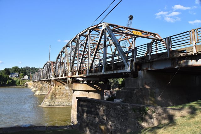
This bridge was an uncommon example of a mid-20th century through truss swing bridge that also included fixed through truss approach spans. Whoever paid the extra money to have a swing span on this bridge was likely highly irritated when navigation on this river ceased a mere year after the bridge's completion. This bridge also has an unusual narrow ramp bridge with a timber deck that leads down to the historic locks north of the bridge and was closed to traffic as of 2020. There also is a structurally separate three span 162 foot steel stringer bridge immediately south of the main bridge that passes over a former intake canal.
Information and Findings From Ohio's Historic Bridge InventorySetting/Context The bridge carries a two lane road and one sidewalk over the river and a lock associated with the improvements to a 91-mile long section of the Muskingum River between Dresden and the Ohio River at Marietta. The river improvement project, which consisted of 10 dams, 5 bypass canals, and 11 locks, was started by the state of Ohio in 1841 to connect the Ohio River with Lake Erie. Dependence on the waterway, however, was short lived as the railroads matured starting in the 1860s. Responsibility for keeping the Muskingum River operational for commercial navigation was transferred to the US Army Corps of Engineers in 1887. The Corps started to rebuild the facilities, and in 1893, they completed a major sandstone lock at Philo. There is also a tender's house adjacent to the lock chamber. In 1933 the Muskingum Watershed Conservation District was created as part of the Corps's larger Ohio River basin flood control project, and WPA funds were used by the federal and state governments to improve the dams, reservoirs, and locks. The state highway department was responsible for all relocated highways and roads. In 1954 the federal project for commercial navigation was discontinued, and ownership of all Muskingum River facilities reverted to the state, who maintain them for recreational use. Physical Description The 5 span, 837' long bridge is composed of 4, 157' long Parker thru truss approach spans and an approximately 200' long, rim bearing, Parker thru truss swing span that is at the south end of the bridge over the 1893 canal lock 9 chamber. The substructure, including the pivot pier, is concrete. The trusses are traditionally composed with built up box section chords and rolled section web members and bracing. No operator's shanty or operating machinery (controls, motors, cables, etc) was observed. It is assumed that the movable span is fixed. The cantilevered sidewalks are finished with 5 rail high metal railings that are a state standard design. Summary of Significance When completed in 1953, the traditionally composed Parker thru truss bridge had a rim-bearing swing span over Lock 9. The bridge was built by the state highway department with federal aid by the state as part of the long-standing Muskingum Watershed Conservation District arrangement with the Corps of Engineers. The state was responsible for all relocated highways while the Corps improved and upgraded the waterway. This is not the first movable bridge at this crossing, and the present bridge has no innovative or distinctive details. It is not historically or technologically significant. It is a late example of a bridge type and design that dates to the late 19th century. It is not operable. Commercial navigation on the waterway was discontinued in 1954. The bridge was designed by the Ohio Department of Highways, and it was fabricated by American Bridge Co. Bridge Considered Historic By Survey: No |
![]()
![]()
![]()
This historic bridge has been demolished. This map is shown for reference purposes only.
Coordinates (Latitude, Longitude):
Search For Additional Bridge Listings:
Bridgehunter.com: View listed bridges within 0.5 miles (0.8 kilometers) of this bridge.
Bridgehunter.com: View listed bridges within 10 miles (16 kilometers) of this bridge.
Additional Maps:
Google Streetview (If Available)
GeoHack (Additional Links and Coordinates)
Apple Maps (Via DuckDuckGo Search)
Apple Maps (Apple devices only)
Android: Open Location In Your Map or GPS App
Flickr Gallery (Find Nearby Photos)
Wikimedia Commons (Find Nearby Photos)
Directions Via Sygic For Android
Directions Via Sygic For iOS and Android Dolphin Browser
USGS National Map (United States Only)
Historical USGS Topo Maps (United States Only)
Historic Aerials (United States Only)
CalTopo Maps (United States Only)

© Copyright 2003-2024, HistoricBridges.org. All Rights Reserved. Disclaimer: HistoricBridges.org is a volunteer group of private citizens. HistoricBridges.org is NOT a government agency, does not represent or work with any governmental agencies, nor is it in any way associated with any government agency or any non-profit organization. While we strive for accuracy in our factual content, HistoricBridges.org offers no guarantee of accuracy. Information is provided "as is" without warranty of any kind, either expressed or implied. Information could include technical inaccuracies or errors of omission. Opinions and commentary are the opinions of the respective HistoricBridges.org member who made them and do not necessarily represent the views of anyone else, including any outside photographers whose images may appear on the page in which the commentary appears. HistoricBridges.org does not bear any responsibility for any consequences resulting from the use of this or any other HistoricBridges.org information. Owners and users of bridges have the responsibility of correctly following all applicable laws, rules, and regulations, regardless of any HistoricBridges.org information.
![]()