


View Information About HSR Ratings
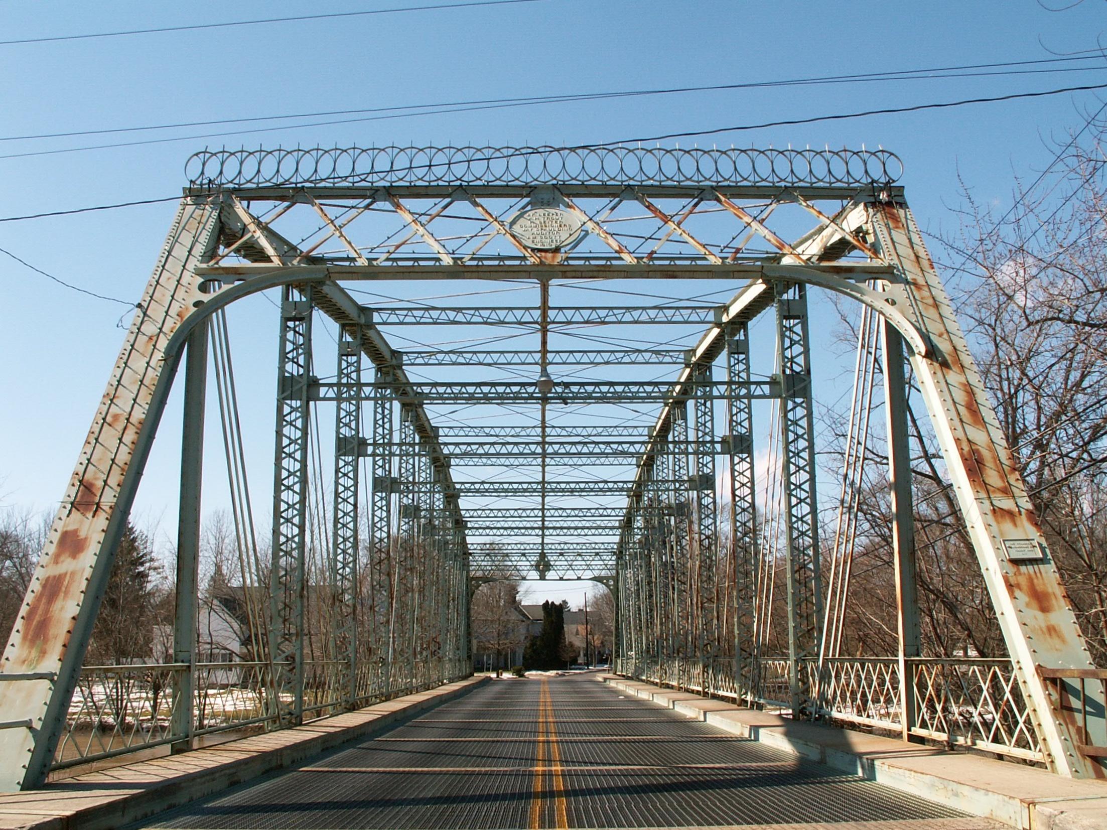
This bridge is a magnificent structure, providing a single clear span of 226 feet over the Scioto River, and composed of eleven panels. It is one of those bridges that acts as a gateway for Prospect, providing a dramatic entrance into the city. It is ornately decorated, featuring attractive portal knee bracing, as well as a decorative design on top of the portal bracing. A late example of a pin-connected truss bridge, this is a very wide bridge, and features an unusual design of bracing overhead, in the form of a section of bracing that runs parallel to the top chord through the sway bracing.
This bridge appears to have once had cantilevered sidewalks, which were removed. The lattice railings from those sidewalks appear to have been saved, and indeed are the railings seen on the bridge today. They are oddly mounted inside the vertical members, and evidence of some cutting of parts of the railings to make them fit around diagonals is apparent. The bridge likely had no railings inside the truss lines prior to this alteration.
This bridge is worthy of being considered historic for its impressive span size. It is an unusually wide structure, and is well-decorated. It acts as an important gateway for Prospect, and is arguably the center attraction of the town. Unfortunately, ODOT does not agree with any of this, and feels that the only way to deal with the poor condition of the bridge is to demolish it. Under Section 106, they offered the bridge to a third party, but as one might guess, the bridge is of a size that only a unit as rich as the government can (and should) have to bear the burden of restoring this bridge for light vehicular or pedestrian use. It would have been nice to see this bridge restored, even with retrofitting, to allow this bridge to remain as an important historic landmark, and gateway for Prospect.
Information and Findings From Ohio's Historic Bridge InventorySetting/Context The bridge carries a 2-lane highway over a stream in an area of 19th and early-20th-century residential and commercial development in Prospect. Physical Description The 1 span, 226'-long, pin-connected Parker thru truss bridge is traditionally composed of built-up compression members and eye bar or rod tension members. The bridge has lattice portals decoratively finished with a circular medallion plaque and wrought-iron crestline. The stringers and open-steel grid deck were replaced in 1985. It's unclear from the available photos but it appears floorbeams were replaced or connections strengthened. The bridge is supported on concrete abutments. Integrity Deck replacement (1985) Summary of Significance The pin-connected Parker thru truss was fabricated by the Standard Engineering Company in 1913. It is a complete and long-span example of its type/design in the state context. It has had a deck replacement, but
that has not compromised its ability to convey its technological significance. A project was planned to replace the bridge in 1999 with an adverse effect, but the bridge is still in place in 2008. The eligible recommendation of the
prior inventory remains appropriate. Justification The later pin connected thru truss bridge is one of 13 extant examples of bridges with polygonal upper chords and/or subdivided panels in the state that date from 1888 until 1923. It is of moderate significance given that the numbers in the population. Bridge Considered Historic By Survey: Yes |
![]()

![]()
![]()

![]()
This historic bridge has been demolished. This map is shown for reference purposes only.
Coordinates (Latitude, Longitude):
Search For Additional Bridge Listings:
Bridgehunter.com: View listed bridges within 0.5 miles (0.8 kilometers) of this bridge.
Bridgehunter.com: View listed bridges within 10 miles (16 kilometers) of this bridge.
Additional Maps:
Google Streetview (If Available)
GeoHack (Additional Links and Coordinates)
Apple Maps (Via DuckDuckGo Search)
Apple Maps (Apple devices only)
Android: Open Location In Your Map or GPS App
Flickr Gallery (Find Nearby Photos)
Wikimedia Commons (Find Nearby Photos)
Directions Via Sygic For Android
Directions Via Sygic For iOS and Android Dolphin Browser
USGS National Map (United States Only)
Historical USGS Topo Maps (United States Only)
Historic Aerials (United States Only)
CalTopo Maps (United States Only)

© Copyright 2003-2024, HistoricBridges.org. All Rights Reserved. Disclaimer: HistoricBridges.org is a volunteer group of private citizens. HistoricBridges.org is NOT a government agency, does not represent or work with any governmental agencies, nor is it in any way associated with any government agency or any non-profit organization. While we strive for accuracy in our factual content, HistoricBridges.org offers no guarantee of accuracy. Information is provided "as is" without warranty of any kind, either expressed or implied. Information could include technical inaccuracies or errors of omission. Opinions and commentary are the opinions of the respective HistoricBridges.org member who made them and do not necessarily represent the views of anyone else, including any outside photographers whose images may appear on the page in which the commentary appears. HistoricBridges.org does not bear any responsibility for any consequences resulting from the use of this or any other HistoricBridges.org information. Owners and users of bridges have the responsibility of correctly following all applicable laws, rules, and regulations, regardless of any HistoricBridges.org information.
![]()