

View Information About HSR Ratings
This bridge is an abandoned highway bridge.
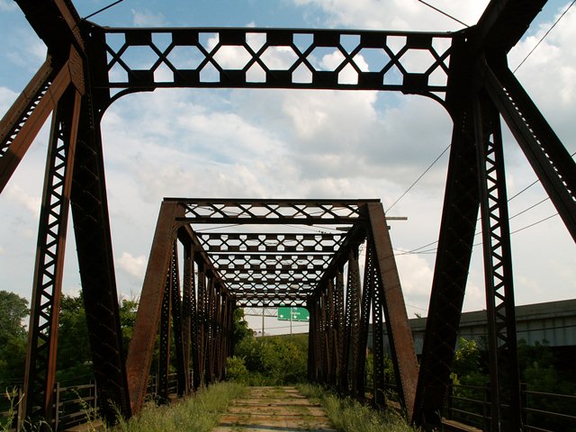
The deck is very interesting because it is brick! Unfortunately, an asphalt layer placed on top hides most of it. The bridge features both v-lacing and lattice, and the portal bracing and sway bracing use an unusual lattice design, which features fairly large gusset plates to fasten the lattice to.
The bridge is an two span Pratt through truss with riveted connections. Each span features eight panels. Cantilevered sidewalks are present on either side of the structure, and may or may not be original. The bridge is closed to vehicular traffic, but pedestrians can still access the structure. The bridge appears to have been closed when the expressway was constructed, since I-75 cut off the south access to this bridge.
Jim McGee provided the following history:
This was a vehicular traffic/road bridge originally known as the Sumner Street bridge. It was also US 23 through Toledo in 1938. US 23 was connected from Broadway to Logan Street, crossing the bridge over the New York
Central Railroad main line and Toledo Union Station, running south to Woodward Avenue where it intersected and became the Fassett Street bridge, crossing the Maumee River Fassett Street intersected with Miami Street and turned south which
is the current day Oh- RT 65.
I remember as a youth growing up in Toledo about the construction of I-75 and the Fassett Street bridge. I had to do some digging to reverify what my mind recollected, and found the evidence in a 1938
USGS map.
![]()
![]()
![]()
Coordinates (Latitude, Longitude):
Search For Additional Bridge Listings:
Bridgehunter.com: View listed bridges within 0.5 miles (0.8 kilometers) of this bridge.
Bridgehunter.com: View listed bridges within 10 miles (16 kilometers) of this bridge.
Additional Maps:
Google Streetview (If Available)
GeoHack (Additional Links and Coordinates)
Apple Maps (Via DuckDuckGo Search)
Apple Maps (Apple devices only)
Android: Open Location In Your Map or GPS App
Flickr Gallery (Find Nearby Photos)
Wikimedia Commons (Find Nearby Photos)
Directions Via Sygic For Android
Directions Via Sygic For iOS and Android Dolphin Browser
USGS National Map (United States Only)
Historical USGS Topo Maps (United States Only)
Historic Aerials (United States Only)
CalTopo Maps (United States Only)

© Copyright 2003-2024, HistoricBridges.org. All Rights Reserved. Disclaimer: HistoricBridges.org is a volunteer group of private citizens. HistoricBridges.org is NOT a government agency, does not represent or work with any governmental agencies, nor is it in any way associated with any government agency or any non-profit organization. While we strive for accuracy in our factual content, HistoricBridges.org offers no guarantee of accuracy. Information is provided "as is" without warranty of any kind, either expressed or implied. Information could include technical inaccuracies or errors of omission. Opinions and commentary are the opinions of the respective HistoricBridges.org member who made them and do not necessarily represent the views of anyone else, including any outside photographers whose images may appear on the page in which the commentary appears. HistoricBridges.org does not bear any responsibility for any consequences resulting from the use of this or any other HistoricBridges.org information. Owners and users of bridges have the responsibility of correctly following all applicable laws, rules, and regulations, regardless of any HistoricBridges.org information.
![]()