HistoricBridges.org Menu: HistoricBridges.org Menu:


We Recommend:
Bach Steel - Experts at historic truss bridge restoration.

HistoricBridges.org: Bridge Browser

Sowell's Bluff Bridge

State Highway 78 Bridge

Sowell's Bluff Bridge

Primary Photographer(s): Nathan Holth

Bridge Documented: August 2, 2019

View Photos
and Videos
View Maps
and Links

Facility Carried / Feature Intersected
OK-78 and TX-78 Over Red River
Location
Rural: Bryan County, Oklahoma and Fannin County, Texas: United States
Structure Type
Metal 10 Panel Rivet-Connected K-Parker Through Truss, Fixed and Approach Spans: Metal 5 Panel Rivet-Connected Camelback Pony Truss, Fixed
Construction Date and Builder / Engineer
1938 By Builder/Contractor: Kansas City Bridge Company of Kansas City, Missouri and Engineer/Design: Oklahoma Highway Commission
Rehabilitation Date
Not Available or Not Applicable
Main Span Length
210.0 Feet (64 Meters)
Structure Length
2,108.0 Feet (642.5 Meters)
Roadway Width
25 Feet (7.62 Meters)
Spans
8 Main Span(s) and 4 Approach Span(s)
Inventory Number
065910000000000

Historic Significance Rating (HSR)
View Information About HSR Ratings

Bridge Documentation

This bridge no longer exists!

Bridge Status: This highly significant historic bridge was demolished and replaced on April 6, 2021!

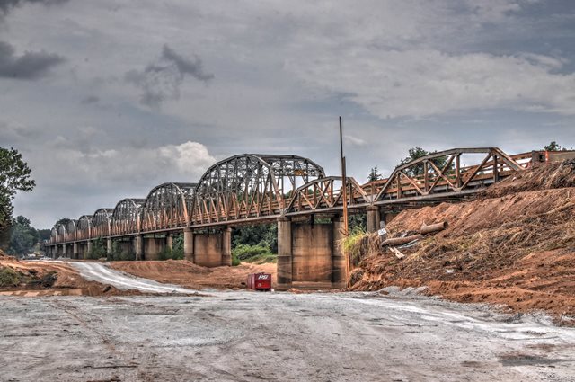
This is one of the longest known K-truss bridges in the entire country. Although its sits on the state line, the heritage of this bridge is an Oklahoma bridge. Designed by Oklahoma engineers, it includes the state's unique K-Parker through truss spans for main spans, and the state's standard pony truss approach spans, two at each end. Oklahoma has decimated its historic bridge population with completely unrelenting demolition. As of 2020, this is one of the last surviving K-truss bridges, and it was always one of the largest. Yet this bridge is being replaced and will be demolished after the replacement is complete. The bridge can carry truck traffic. This bridge absolutely should have been left standing for pedestrian use next to its replacement bridge. It is one of the most significant historic bridges in Oklahoma.

View Archived National Bridge Inventory Report - Has Additional Details and Evaluation

View Historic Bridge Inventory Sheet For This Bridge

View National Register of Historic Places Nomination Form For This Bridge

Divider

Photo Galleries and Videos: Sowell's Bluff Bridge


View Photo Gallery

Bridge Photo-Documentation

Original / Full Size Photos
A collection of overview and detail photos. This gallery offers photos in the highest available resolution and file size in a touch-friendly popup viewer.
Alternatively, Browse Without Using Viewer

Divider

View Photo Gallery

Bridge Photo-Documentation

Mobile Optimized Photos
A collection of overview and detail photos. This gallery features data-friendly, fast-loading photos in a touch-friendly popup viewer.
Alternatively, Browse Without Using Viewer

Divider

View Video

Driving Over Bridge

Full Motion Video
Note: The downloadable high quality version of this video (available on the video page) is well worth the download since it offers excellent 1080 HD detail and is vastly more impressive than the compressed streaming video. Streaming video of the bridge. Also includes a higher quality downloadable video for greater clarity or offline viewing.

Divider

Maps and Links: Sowell's Bluff Bridge

This historic bridge has been demolished. This map is shown for reference purposes only.

Coordinates (Latitude, Longitude):

Search For Additional Bridge Listings:

Bridgehunter.com: View listed bridges within 0.5 miles (0.8 kilometers) of this bridge.

Bridgehunter.com: View listed bridges within 10 miles (16 kilometers) of this bridge.

HistoricBridges.org Bridge Browser: View listed bridges within 0.5 miles (0.8 kilometers) of this bridge.

HistoricBridges.org Bridge Browser: View listed bridges within 10 miles (16 kilometers) of this bridge.

2021 National Bridge Inventory: View listed bridges within 0.5 miles (0.8 kilometers) of this bridge.

Additional Maps:

Google Maps

Google Streetview (If Available)

Bing Maps

OpenStreetMap

GeoHack (Additional Links and Coordinates)

Apple Maps (Via DuckDuckGo Search)

Apple Maps (Apple devices only)

MapQuest

HERE We Go Maps

ACME Mapper

Waze Map

Android: Open Location In Your Map or GPS App

Flickr Gallery (Find Nearby Photos)

Wikimedia Commons (Find Nearby Photos)

Directions Via Sygic For Android

Directions Via Sygic For iOS and Android Dolphin Browser

USGS National Map (United States Only)

Historical USGS Topo Maps (United States Only)

Historic Aerials (United States Only)

CalTopo Maps (United States Only)


Divider
 
Home Top

Divider

About - Contact

© Copyright 2003-2024, HistoricBridges.org. All Rights Reserved. Disclaimer: HistoricBridges.org is a volunteer group of private citizens. HistoricBridges.org is NOT a government agency, does not represent or work with any governmental agencies, nor is it in any way associated with any government agency or any non-profit organization. While we strive for accuracy in our factual content, HistoricBridges.org offers no guarantee of accuracy. Information is provided "as is" without warranty of any kind, either expressed or implied. Information could include technical inaccuracies or errors of omission. Opinions and commentary are the opinions of the respective HistoricBridges.org member who made them and do not necessarily represent the views of anyone else, including any outside photographers whose images may appear on the page in which the commentary appears. HistoricBridges.org does not bear any responsibility for any consequences resulting from the use of this or any other HistoricBridges.org information. Owners and users of bridges have the responsibility of correctly following all applicable laws, rules, and regulations, regardless of any HistoricBridges.org information.

Admin Login

Divider